(Jisr al-Zarqa) – The Israeli government’s policy of boxing in Palestinian communities extends beyond the West Bank and Gaza to Palestinian towns and villages inside Israel, Human Rights Watch said today. The policy discriminates against Palestinian citizens of Israel and in favor of Jewish citizens, sharply restricting Palestinians’ access to land for housing to accommodate natural population growth.
Decades of land confiscations and discriminatory planning policies have confined many Palestinian citizens to densely populated towns and villages that have little room to expand. Meanwhile, the Israeli government nurtures the growth and expansion of neighboring predominantly Jewish communities, many built on the ruins of Palestinian villages destroyed in 1948. Many small Jewish towns also have admissions committees that effectively bar Palestinians from living there.
“Israeli policy on both sides of the Green Line restricts Palestinians to dense population centers while maximizing the land available for Jewish communities,” said Eric Goldstein, acting Middle East executive director at Human Rights Watch. “These practices are well-known when it comes to the occupied West Bank, but Israeli authorities are also enforcing discriminatory land practices inside Israel.”
The Israeli state directly controls 93 percent of the land in the country, including occupied East Jerusalem. A government agency, the Israel Land Authority (ILA), manages and allocates these state lands. Almost half the members of its governing body belong to the Jewish National Fund (JNF), whose explicit mandate is to develop and lease land for Jews and not any other segment of the population. The fund owns 13 percent of Israel’s land, which the state is mandated to use “for the purpose of settling Jews.”

Palestinian citizens of Israel constitute 21 percent of the country’s population, but Israeli and Palestinian rights groups estimated in 2017 that less than 3 percent of all land in Israel falls under the jurisdiction of Palestinian municipalities. The majority of Palestinians in Israel live in these communities, although some live in “mixed cities” like Haifa and Acre.
In preparing this report, Human Rights Watch compared neighboring Palestinian towns and Jewish or Jewish-majority communities in 3 of Israel’s 6 districts, interviewing 25 current and former local municipal officials, representatives of regional planning councils, residents, and planners. Human Rights Watch also visited each location and reviewed land records and aerial photography. Human Rights Watch received a substantive response from the Israeli Planning Administration (IPA) to its findings.
Beginning in 1948 and in subsequent decades, Israeli authorities seized hundreds of thousands of dunams of land from Palestinians (10 dunams equals 1 hectare). Much of the confiscation took place between 1949, when Israel placed most Palestinians in Israel under military rule, and 1966, when military rule ended. During this period, Israeli authorities confined Palestinians in Israel to dozens of enclaves and severely restricted their movement. They also used various military regulations and new laws to seize land belonging to Palestinians who had become refugees or Palestinian citizens who were internally displaced, including by declaring land to be “absentee property,” taking it over, and later converting it to state land. One historian estimates that of the 370 Jewish towns and villages established by the Israeli government between 1948 and 1953, 350 were built on land confiscated from Palestinians.
Land policies in more recent years have not only failed to reverse the earlier land seizures, but in many cases further restricted the land available for residential growth. Since 1948, the government has authorized the creation of more than 900 “Jewish localities” in Israel, but none for Palestinians except for a handful of government-planned townships and villages in the Negev and Galilee, created largely to concentrate previously dispersed Bedouin communities.
In the 1970s, Israeli authorities brought Palestinian towns and villages into the state’s centralized planning system, but planning processes have not significantly increased the land available for residential building. The authorities have zoned large sections of Palestinian towns and villages for “agricultural” use or as “green” areas, prohibited residential building in them, and built road and other infrastructure projects that impede expansion. A 2003 Israeli government-commissioned report found that “many Arab towns and villages were surrounded by land designated for purposes such as security zones, Jewish regional councils, national parks and nature reserves or highways, which prevent or impede the possibility of their expansion in the future.”

These restrictions create density problems and a housing crunch in Palestinian communities. The Arab Center for Alternative Planning, based in Israel, told Human Rights Watch that it estimates that 15 to 20 percent of homes in Palestinian towns and villages lack permits, some because owners’ applications were rejected and others because they did not apply knowing that authorities would reject their requests on the grounds that they were contrary to the existing zoning. The group estimates that 60,000 to 70,000 homes in Israel, excluding Jerusalem, are at risk of full demolition. A 2017 amendment to Israel’s 1965 Planning and Building Law, known as the “Kaminitz Law,” increases “enforcement and penalization of planning and building offenses.” As of July 2015, 97 percent of Israel’s 1,348 judicial demolition orders in force were for structures located in Palestinian towns.
By contrast, in the cases reviewed by Human Rights Watch, planning authorities provided sufficient land and zoning permissions to similarly-situated, predominantly Jewish communities to facilitate their growth.
In responding to questions submitted by Human Rights Watch, a senior official in the IPA disputed that Israel hems in Palestinian towns and villages. The IPA, she said, has approved or is currently preparing master plans for 119 of the 132 Palestinian localities in Israel. Based on these plans, authorities approved 160,000 housing units in these areas between 2012 and 2019, including 42,000 in 2019, and “legaliz[ed] thousands of existing structures,” she said.
While these efforts have resulted in some residential development in certain towns, much has yet to be implemented, with many projects still requiring further approvals to come to fruition – and they have done little to date to change the reality of hemmed-in Palestinian towns and villages.
Israeli law permits towns in the Negev and Galilee (which comprise two-thirds of the land in Israel) with up to 400 households to maintain admissions committees that can reject applicants from living there for being “not suitable for the social life of the community” or for incompatibility with the “social-cultural fabric.” This authority effectively permits the exclusion of Palestinians from small Jewish towns, which Adalah, a human rights group based in Haifa, estimated in 2014 make up 43 percent of all towns in Israel, albeit a far smaller percentage of the country’s population. In a 2015 study, Yosef Jabareen, a professor at the Technion-Israel Institute of Technology in Haifa, found that there are more than 900 small Jewish towns, including kibbutzim, across Israel that can restrict who can live there and have no Palestinian citizens living in them.
Human Rights Watch documented in 2008 discriminatory Israeli policies and practices that left tens of thousands of Palestinian Bedouins in southern Israel living in “unrecognized” informal settlements, where their homes face the constant threat of demolition, and in 2010, discriminatory planning in a Palestinian village near Tel Aviv.
International human rights law prohibits racial and ethnic discrimination, condemns “racial segregation,” and safeguards the right to adequate housing. The International Covenant on Economic, Social, and Cultural Rights (ICESR), which Israel has ratified, requires states to ensure that policies and legislation progressively realize the right to adequate housing for all segments of society. The body tasked with interpreting the covenant has said that “enjoyment of this right must … not be subject to any form of discrimination” and that “increasing access to land by landless or impoverished segments of the society should constitute a central policy.”
To address the housing shortage among Palestinian citizens of Israel and the legacy of land confiscation from Palestinian towns and villages, Israeli authorities should prioritize the growth needs of Palestinian communities in the zoning process, allocate state land to and expand Palestinian towns, and eliminate the legal loophole that permits discrimination by admissions committees.
“Israeli land policies treat towns inside its own borders in starkly unequal terms based on whether its inhabitants are Jewish or Palestinian,” Goldstein said. “After decades of confiscating Palestinians’ land, Israel confines them to crowded towns while enabling neighboring Jewish towns that exclude them to flourish.”
Planning in Israel
Israeli law centralizes planning under the central government – historically the Interior Ministry, but that largely shifted to the Finance Ministry in 2015. The 1965 Planning and Building Law creates a three-tiered hierarchy of planning bodies that draw up and carry out master plans at the national, district, and local levels. At the highest level, the National Board for Planning and Building prepares national master plans, expressing a national vision for everything from land use to development, and submits it to the government for approval. Based on the national plan, district and local commissions formulate local plans.
While the planning process is designed to provide opportunity for engagement at the regional and local levels, in practice it marginalizes Palestinian citizens of Israel, whose representation in government planning bodies is far smaller than their proportion of the overall population and whose needs are rarely prioritized. Outside of the government committees, the only option for individuals to offer input is by filing objections to particular plans.
Israeli Government Response
The IPA wrote in a March 18 letter to Human Rights Watch that it disagrees that “Israeli policy restricts and confines Arab towns and villages.” It notes that it has “put a great deal of effort into planning through the entire hierarchy of planning institutions in order to advance and strengthen Arab communities” and has created “tremendous planning momentum in these communities.”
The IPA attributes the challenges of planning in these communities, including the “many unutilized agricultural enclaves,” primarily to the high percentage of privately owned land, estimating that about 20 percent of the population owns 80 percent of the land. It further cites “a short supply of land for public use … large-scale unregulated building … challenging topographical conditions” and the prevalence of spread-out single-family dwellings, which “precludes solutions for young couples” and leads to “multi-generational construction,” “forcing the authorities to deliver infrastructure over an expansive area.”
The IPA claims its recent planning efforts address these challenges by “legalizing thousands of existing housing units” and allocating “state-owned land that would allow large-scale construction of housing units” and “public spaces needed for these additional housing units.” The result, according to the IPA, is “masterplans that include new areas for development on an extremely extensive scale, and are suited to contain a number of housing units far exceeding the programmatic and demographic needs of the community.”
In December 2015, the authorities approved a 5-year, more than 10 billion NIS (US$2.93 billion) “economic development plan for the Arab sector.” Assessing progress in an “interim report” published in 2019, the Israeli group “Bimkom: Planners for Planning Rights” noted an increase in planning activity in Palestinian towns, including steps to allow for more housing construction, but observed that the housing shortage in Palestinian municipalities would continue without the state allocating them more state land.
Case Studies
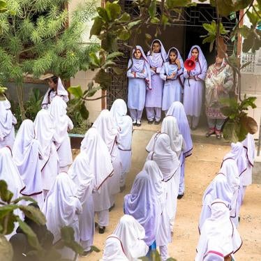
Jisr Al-Zarqa (Haifa District)

Jisr al-Zarqa, between Netanya and Haifa in northwest Israel, is the only Palestinian town in Israel on the Mediterranean coast. Israel’s Central Bureau of Statistics lists its population as 14,700. Jisr al-Zarqa, a local council in the Haifa District with a size of about 1,600 dunams, is one of Israel’s poorest towns, with about 80 percent of residents living below the poverty line.
Policies of Israeli governments and institutions under the British mandate dating back almost a century have effectively boxed in its residents. In the early 1920s, the Palestine Jewish Colonization Association, according to Israel’s Foreign Ministry, drained the swamps, from which local residents derived their livelihood herding buffalos and weaving reed mats, to make room for new Jewish settlements. Residents say they ended with roughly their current plot of land, far less than they had historically lived on.
While largely spared the destruction and displacement that befell the nearby towns of Tantura and Qisarya during Israel’s establishment in 1948, Jisr al-Zarqa nonetheless came under military rule, as did virtually all other Palestinian towns and villages inside Israel until 1966. During this period, Israeli authorities laid the basis for hemming the town in. Planning and zoning policies in the years since have further restricted its residents’ access to land and housing.
To its north, Israeli authorities in August 1949 granted thousands of dunams of state land to the Jewish Kibbutz of Ma’agan Michael, partly around a cemetery used for years by Jisr al-Zarqa residents. Ma’agan Michael in the 1970s built fish ponds on its land that extend south to the area west of the northern section of Jisr al-Zarqa. Israeli authorities established the Taninim Stream Nature Reserve east of the ponds to protect the stream. This 470-dunam reserve, where construction is prohibited, blocks Jisr al-Zarqa from expanding to the north. Murad Ammash, the head of the Jisr al-Zarqa village council, told Human Rights Watch that 90 of the dunams of this preserve consists of land privately owned by Jisr al-Zarqa residents.
Authorities also zoned part of the area for agricultural use, forbidding residential construction. One of the people who owns land in the area designated for agricultural use, Zaem Ammash, unrelated to Murad, but who serves as a civil servant at the village council, told Human Rights Watch that he sees the land “every day, through my window – there is only one street that separates my house from this land – and yet I cannot move and live on it.”
To the east lies Highway 2, which runs north to south, separating the town from agricultural lands to the east that used to belong to residents. Israeli authorities decided to build Highway 2 in the 1960s, when Jisr al-Zarqa residents, under military rule, had little means to challenge the route. Israel took over as state land the roughly 1,600 dunams east of the highway, much of which the Jisr al-Zarqa village council say its residents own and used to farm on. Most of these lands today fall under the jurisdiction of the nearby Jewish moshav, or community that maintains cooperative practices, of Bait Hanania.
Israel has not built entrance or exit ramps off the highway for Jisr al-Zarqa. Not having a highway exit adds 15 to 20 minutes to commutes north or south and leaves 2 options to enter Jisr al-Zarqa by car. One is an underpass originally used as a water aqueduct that is only slightly wider than a single car, and the other is a road between the northern end of the village and the Taninim Stream Nature Reserve.

To the south, Israeli authorities in 1952 established Caesarea on the site of the Palestinian village of Qisarya. The Haganah, a Jewish paramilitary group, expelled the Qisarya residents in February 1948, according to the Israeli historian Benny Morris. Today Caesarea, which is run by the Caesarea Development Corporation, a private company, is the upscale hometown of Prime Minister Benjamin Netanyahu. It includes villas, a golf course, a harbor, an archaeological site, and an industrial and business park.
For years, many Jisr al-Zarqa residents worked in Caesarea, largely as house cleaners or manual laborers. However, in 2002, the Caesarea Development Corporation built an earthen berm, 1.2 kilometers long and between 9 to 12 meters high, between Caesarea and Jisr al-Zarqa. The berm blocks the view of Jisr al-Zarqa from Caesarea. Ammash, the village council head, said the berm blocks easy access for residents working in Caesarea and “deflated the morale and hopes” of residents. The berm, he said, made them feel like the people of Caesarea “don’t consider us human beings” and want to “cover up” their existence.
To the west lies the Mediterranean. Israeli law largely prevents building within 100 meters of the coast. Adjacent to the sea, Israeli authorities established two nature reserves.
Squeezed in all directions and with a rapidly expanding population, Jisr al-Zarqa faces a major density problem, a housing crunch, and serious socioeconomic challenges. Its population density of 9,178 people per square kilometer, according to Israel’s Central Bureau of Statistics, is nearly 3 times that of the predominantly Jewish nearby city of Or Akiva (3,288), more than 10 times Caesarea (807), and more than 30 times Ma’agan Michael (304). Wardah Jurban, a 26-year-old student who lives with her family of 6 in a 95-square-meter house in Jisr al-Zarqa, says the town feels so crowded that “your neighbors can see the inside of your house from their window.”
Ahmed Juha, owner of Juha’s Guesthouse, the town’s only hostel, said that when he opened it in 2014 he had to seek an exception to an Israeli law that requires a dedicated parking lot, since the nearest one is 500 meters away. The Israeli rights group Bimkom estimated in 2014 that Jisr al-Zarqa would need 730 additional housing units to solve its housing shortage at the time.
The squeeze underscores the socioeconomic challenges facing Jisr al-Zarqa, which has no industrial zone, emergency health services, post office, bank, or bank-operated ATM machine, and few public or recreational sites or facilities. It lacks basic infrastructure and services. According to the Haifa-based rights group Mossawa, less than a quarter of the town’s students graduate high school and the life expectancy of its residents is twenty years below the national average. Ammash, the village council head, said “there is no quality of life in Jisr al-Zarqa” and that to him “the goal [of such polices] is clear: to suffocate and displace us.”

The stark differences with its neighbors grow directly out of discriminatory Israeli policies. The state, for example, granted the kibbutz of Ma’agan Michael more than 5,000 dunams of state land. Nir Bracha, the kibbutz’s general director, told Human Rights Watch that the state zoned less than 10 percent of its land for housing, but in several instances over time reclassified land from agricultural to residential to accommodate the kibbutz’s housing needs. Bracha noted that, to help it surmount a housing shortage in recent years, the government required it to build some taller buildings as a condition for rezoning more land for housing.
The kibbutz also manages fish ponds larger than all of Jisr al-Zarqa and has an industrial zone that includes the headquarters of the major plastics company, Plasson. On Jisr al-Zarqa, Bracha acknowledged that “historical and political issues,” in particular “keeping land for the Jews,” has left the town “squeezed.” However, Bracha also stated that Jisr al-Zarqa has benefitted from “positive discrimination” in recent years – a reference to measures the state has taken to address the squeeze.
In 2016, the Israeli authorities approved a plan to expand Highway 2, which includes moving the section abutting Jisr al-Zarqa to the east and creating entry and exit ramps for the town. In 2018, the authorities approved a master plan for Jisr al-Zarqa that would, according to the IPA, create “new development areas” in the space created by moving the highway east, including “higher-density multi-story [residential] building, as well as public spaces.” Ammash, the village council head, said this plan would provide an extra 240 dunams for Jisr al-Zarqa, though noted that it falls short of the 1,200 dunams the municipality requested in this area in 2005 based on a needs assessment it conducted. The IPA said it has proposed plans that could create 700 housing units in this area.
The IPA also said the master plan authorizes construction of 1,500 housing units in the residential core. It also rezones some “green” areas, including a section north of the town near the Nahal Taninim Reserve, to allow for residential construction and permits some residential building near the coast. The IPA has proposed plans for these areas, it says, that could create 930 housing units.
The authorities, however, have yet to authorize construction based on them and many steps remain before they could come to fruition. In January 2019, the Transportation Ministry claimed that it lacked the 600 million NIS ($174 million) necessary to reroute Highway 2, according to minutes of a governmental meeting with Jisr al-Zarqa residents reviewed by Human Rights Watch. Ammash said Jisr al-Zarqa proposed in May 2019 to develop this land even if Highway 2 stayed in place, but the authorities denied that request on the grounds that it would affect the territorial contiguity of the town, he said. The IPA, in an email to Human Rights Watch, said they expected that when a government is formed following March 2 elections, it would discuss the highway’s diversion.
Qalansawa (Central District)

The Palestinian town of Qalansawa, home to 22,800 people, is in Israel’s Central District, in a heavily Palestinian region known as the “Triangle.” Although Qalansawa has roughly 8,400 dunams within its municipal boundaries, Israeli land and planning policies have confined the residential zone to the developed city center, which is about half that size, creating both a density problem and a housing shortage.
Qalansawa lost more than half its land as a result of the events around the establishment of Israel in 1948 and in the two decades that followed. A land survey cited in a 2017 letter by the Qalansawa municipality to the Interior Ministry reviewed by Human Rights Watch shows a land mass of 17,249 dunams, while a municipal official told Human Rights Watch that the actual size of the town’s boundaries before 1948 was closer to 30,000 dunams. Israeli authorities seized much of the land west of Qalansawa in the 1950s and 1960s, as documented in a 1976 publication by Palestinian lawyer and scholar in Israel Sabri Jiryis, during the period of Israeli military rule over most of the Palestinian population in Israel, including through laws allowing it to take control of land it designated as “absentee property.”
During the same period, Israel also began building infrastructure projects on Qalansawa’s territory, further limiting the land available for expansion. The first of these projects, a water pipeline system built in the 1960s, cuts a roughly 2.5-kilometer-long, 50-meter-wide swath through the city, according to Nadi Tayeh, the engineer in charge of planning for the municipality. The pipeline, at the western edge of the residential area, effectively demarcates the edge of the town’s residential core.
Israeli authorities in the 1990s built an electricity line through the city’s territory. The Popular Committee for the Defense of Land and Housing in Qalansawa, a grass-roots group that works on land-related issues, told Human Rights Watch that Israeli law prohibits building within a 150 meter zone around the line, which runs for 3.5 kilometers and reduces the land where residents can build by 500 dunams. They said that authorities have issued demolition orders for about 25 homes and 20 commercial structures allegedly built within the 150-meter zone. Tayeh, the municipal official, believes that the lines devalue land in the zone by 60 to 70 percent and worries about the safety and health risks for those living there.
Israeli authorities also prohibit building near the Alexander River, which flows through the municipality, including through the center of the residential area, for about four kilometers. The Popular Committee estimates that the prohibition, which covers 75 meters on each bank in the agriculture zone, and 35 in the residential zone, further reduces the land where residents can build by 500 dunams.
Israeli authorities only began formal planning in Qalansawa in the 1970s and until 2017 had not approved a comprehensive plan for the municipality, the Popular Committee said. Planning decisions have significantly restricted the land available for residential use. Most significantly, Israeli authorities zoned virtually all of north Qalansawa and parts of the east and west – a total of about 4,200 dunams, or half the municipality – for agriculture use and prohibited building of residential units there.
A 31-year-old Qalansawa resident said that her family owns a 400-square-meter property in an area restricted to agricultural use, only a few meters from the residential zone. She hoped to build their family house there, but, despite years of efforts through the municipality and directly with planning authorities, they were unable to change the classification of the land and instead moved to a nearby Palestinian village.
Mohammad Odeh, a 52-year-old father of 3, said he decided in 2015 to build a home on property he owns in an agricultural area despite not having a permit, to move out of what he described as the “warehouse” he lived in, which leaked and had an insect infestation. He received a demolition order within months of beginning construction in 2016. He filed a legal challenge, has organized demonstrations, and even recorded a video that went viral suggesting he would kill himself if the demolition were carried out. He lives in his unfinished home with the threat of demolition looming.
Tayeh, the municipal engineer, said that 600 to 700 structures – including some homes – in the agricultural zone face demolition orders for being built without a permit. Some residents in the residential center also never applied for building permits, in many cases because their homes do not comply with Israeli regulations, usually because they expanded in a way not allowed under the plan. The Popular Committee estimates that about 7,500 Qalansawa residents, or 30 percent of the population, do not own land in the town and struggle to make ends meet, while another 35 percent own property, but need to expand to accommodate their family’s needs.
During the process that led to approving Qalansawa’s first master plan in 2017, residents, activists, and municipal officials say they filed more than 4,000 objections to the plan. These objections included requests to rezone much of the agricultural land, allocate 1,200 dunams of state land near Qalansawa to the municipality, relocate the electricity line outside the municipality, and block plans to build 2 roads through Qalansawa’s territory.
In response, the authorities in 2016 amended Israel’s national plan to approve in principle rezoning 2,800 dunams in the agricultural zone for residential use. This amendment, though, was not reflected in the master plan for Qalansawa, meaning it could take a decade or more before any residential building can start, given all the approvals required, the Popular Committee said. It also noted that under the master plan, the state did not allocate any state land to Qalansawa and did not relocate state infrastructure projects.
The IPA says it has approved building 2,400 housing units in Qalansawa over the past 5 years and that the authorities are preparing “a new policy document” that could facilitate additional growth.
While Israeli authorities have demolished only a small number of homes in Qalansawa – 25 according to the Popular Committee, including owners who demolished their own structures in the face of demolition orders – the threat of demolition exacts a heavy cost. Tayeh links some of the town’s social ills, including drugs and crime, to youth feeling “there is no hope to build a home, family, and future in the town.”
Abu Ameed Makhlouf, a 60-year-old father of 9, said that in 2017, authorities demolished 2 homes he built for his sons on the grounds that he lacked a permit, and that another son pays 2,000 NIS ($583) in monthly fines and must obtain a permit within 2 years to avoid the same outcome. He said he built without permits because “[he] didn’t have an alternative,” that the family lives “under constant stress and fear,” and that the demolitions “ruined [their] lives.”

Sha’ar Efraim, an all-Jewish moshav built in the 1950s, borders Qalansawa to the east. The community has an admissions committee and faces few of the challenges that confront its neighbor. Iris Engel, director of the planning and construction committee for the regional council of Lev Hasharon, which includes Sha’ar Efraim but not Qalansawa, said that the national infrastructure projects have not restricted Sha’ar Efraim’s growth. Sha’ar Efraim, in fact, built gates at its entrances and sometimes prevents non-residents from using the road passing through it. Most of the moshav’s land is zoned for residential building. No homes there currently face demolition orders, and prior plans have permitted building on agricultural land, Engel said.
Ein Mahel (Northern District)

Ein Mahel, a town of about 13,000 Palestinian residents with an area of about 5,200 dunams near Nazareth in Israel’s Northern District, is surrounded on all sides by the Jewish-majority city of Nof HaGalil, which until 2019 went by the name Nazareth Illit (Upper Nazareth). Nof HaGalil, with nearly 33,000 dunams of land, has a population of 41,200 people, many of whom immigrated from Eastern Europe in the 1980s and 1990s.
Formally a “mixed city,” with about 26 percent of its population now Palestinian, Israeli authorities from the outset envisioned Nazareth Illit as a “Jewish town that will assert a Jewish presence in the area,” as Israel’s first Prime Minister David Ben-Gurion wrote in 1957. As the Israeli army’s then-Planning Department Director Yuval Ne’eman put it, the town would “emphasize and safeguard the Jewish character of the Galilee as a whole.” Nazareth Illit constituted a key part of the government’s strategy to “Judaize the Galilee.” The then-northern military governor, Colonel Mikhael Mikhael, wrote that Nazareth Illit would “swallow up” Nazareth, a Palestinian city, and result in the “transfer of the center of gravity of life from Nazareth to the Jewish neighborhood.”
Nof HaGalil, bordering Nazareth, wholly surrounds Ein Mahel and weaves between five other Palestinian towns and villages, impeding the establishment of a larger, contiguous Palestinian municipal area.
During the period of military rule over most Palestinian citizens, including the residents of Ein Mahel, the Israeli authorities in 1957 established Nazareth Illit in part on lands they confiscated from Ein Mahel including under laws governing “absentee property,” as documented in a book by a Palestinian lawyer in Israel, Hussein Abu Hussein, and the British human rights lawyer Fiona McKay. Confiscations continued after the end of military rule, including more than 1,000 additional dunams confiscated in the mid 1970s. Ein Mahel today is about one third its original size, according to the local council.
Planning policies restrict residents to building in the roughly 2,000 dunam residential core of the village. The first plan for Ein Mahel in 1982 and second plan in 1996 zoned the majority of Ein Mahel’s land for agricultural use. Sa’ed Abu Leil, a retired teacher, said that those who live in the residential core, as he does, face a housing crunch, with many young people moving reluctantly outside the village, including to Nof HaGalil/Nazareth Illit.
The plans did create some more space for residential construction, but much of the land allocated was privately owned, Abu Leil said. Rezoning privately owned land, though, will not necessarily create housing for those who do not own land and cannot afford to buy any – who, according to Abu Leil, account for 20 to 30 percent of Ein Mahel’s population. The allocation of state land may be required to achieve that objective.
A 53-year-old dentist, Marwan Habiballah, said Israeli authorities confiscated about 11 dunams of his land in 1976 as part of a larger government confiscation of about 20,000 dunams that triggered protests that activists mark annually on March 30 as “Land Day.” He said he filed a lawsuit which resulted in an offer of financial compensation that he refused. His family owns 9 to 10 dunams of land in the agricultural zone near the built-up area, but, unable to build on it, he says he has no choice but to remain in his home on land he inherited from his grandfather in the residential core that he says is too small for his family of 6. He contemplated moving to Nof HaGalil but said he cannot afford the rent there.
Saher Abu Leil, a 40-year-old physiotherapist with a graduate degree from Tel Aviv University and a father of five, said that he left Ein Mahel, where he grew up, for Nazareth Illit in 2010 due to the housing crunch. He said he would not have moved if he could have built a home on a roughly four dunam piece of land his family owns in southeastern Ein Mahel, but authorities zoned this area for agricultural use. He sought to buy a home in Ein Mahel in 2015, but said a bank denied him a loan, contending the property would not net a good return if he defaulted.

While boxing in Ein Mahel, Israel authorities have allowed Nof HaGalil to grow rapidly. Building on state land and designating it a priority development area, Israeli authorities invested heavily in Nof HaGalil, including establishing the Tziporit Industrial Zone, which includes factories and a park for high-tech companies and is slated to encompass 3,560 dunams. Nof HaGalil, also home to the headquarters of the Strauss-Elite chocolate factory, receives all the local tax revenues from these industries, with none going to the town it envelops, Ein Mahel.
The authorities have also not zoned any of the city’s land for agriculture, according to the city’s general manager Hava Bachar. Ein Mahel, by contrast, has no industrial zones and few dedicated public areas. As Sa’ed Abu Leil put it, Ein Mahel is “a place to reside, but not to live.”
Thousands of Palestinian citizens have moved to Nof HaGalil in recent years, largely purchasing property from Jewish Israelis who were resettled there as immigrants and earned enough to “head for a better life in the center of the country,” according to Nazareth-based journalist Jonathan Cook. Bachar attributes the arrival of Palestinians in Nof HaGalil to the fact that “nearby towns do not have space to grow.” She noted that Nof HaGalil gave a piece of its land for a cemetery for Ein Mahel residents, but was unwilling to “give away land,” given “our ambition to reach 100,000 citizens.” She suggested instead that Israel should build “a new city for Arab citizens.”
Bachar said that the city is “bringing in Jewish families to settle” in order to “ensure it stays Jewish.” Nof HaGalil does not have a state school to serve the roughly 3,000 school-age Palestinian children, forcing most to commute to Nazareth, since Palestinian and Jewish Israelis attend separate schools. The then-mayor in 2013 told the Washington Post that “I would rather cut off my right arm than build an Arab school.”
IPA says it is in the process of approving a comprehensive plan for Ein Mahel. An Ein Mahel official said that the village has requested that the plan rezone agricultural land to permit residential construction and allocate it state land. The draft plan, it says, would – if approved – rezone agricultural land, including some outside the town’s jurisdiction, as a residential area with 12,000 housing units, as compared with the 3,000 housing units currently in the village.