A City Devastated
Human Rights Watch, SITU Research, and Truth Hounds conducted a damage assessment of the city of Mariupol using satellite imagery taken between October 2021 and May 2022. We assessed damage to houses and apartment blocks, to public infrastructure such as hospitals and schools, as well as to water and electricity infrastructure. The destruction left parts of the city uninhabitable.
We combined geospatial analysis with audiovisual analysis of videos and photographs, shared directly with us or posted to social media by witnesses of destruction, which we then verified, as well as other third-party reports of damage.
93% of apartment blocks in 14 square kilometers around Mariupol’s Drama Theater were damaged.
97% of educational facilities, including schools and universities, across the city were damaged.
100% of Mariupol’s hospitals were damaged.
All residents were cut off from the entire city’s water and electricity systems from March 2, 2022.
Overall Damage Assessment
Damage to Key Buildings
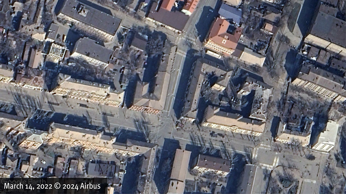
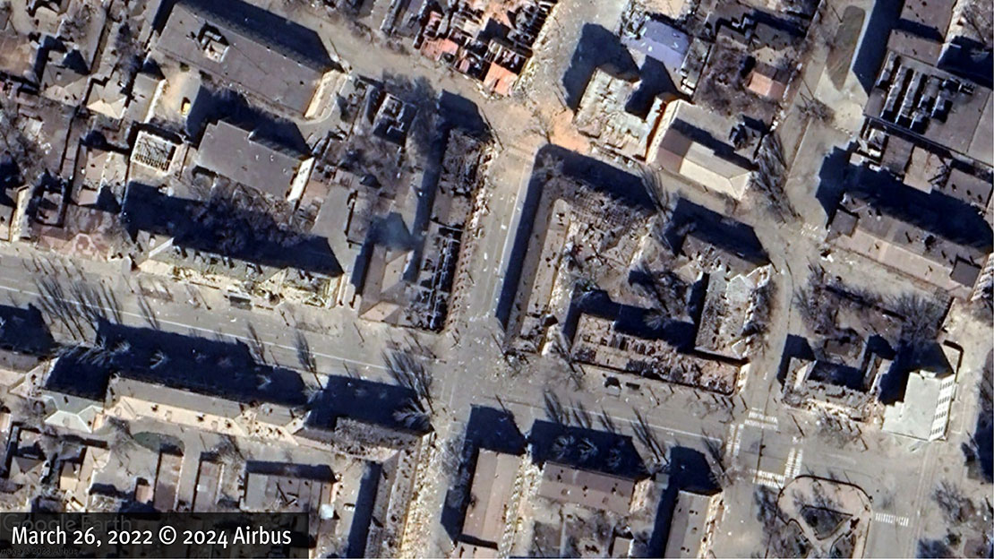
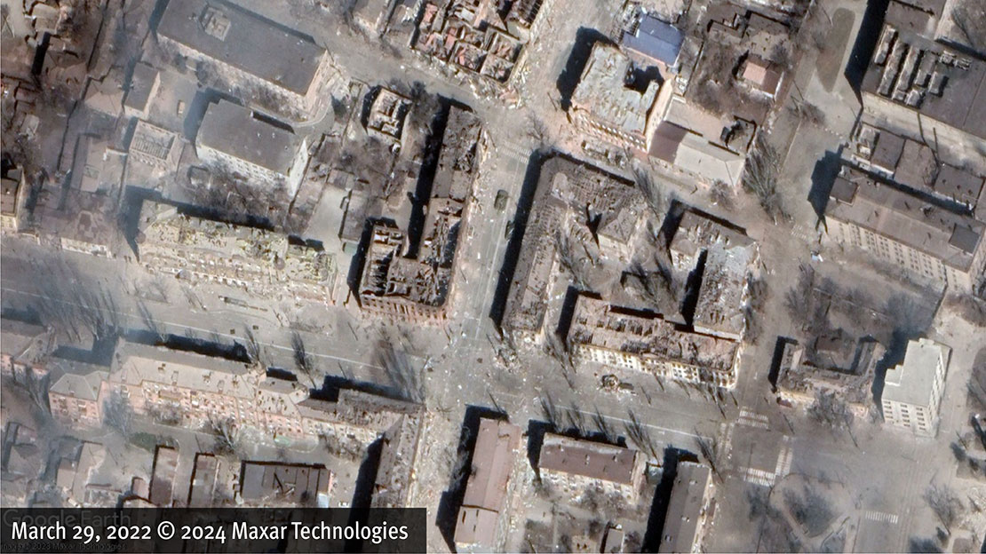
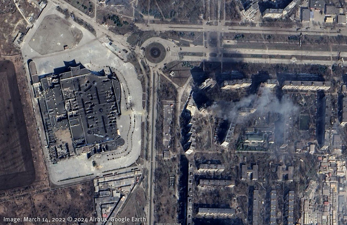
An air-dropped munition hit Mariupol’s Drama Theater on March 16, 2022, destroying the building, and killing at least 15 people who were sheltering there.
But attacks around the main artery of Myru Avenue had begun about two weeks before.
To understand how the city was made virtually unlivable, we selected a sample area of the city representative of the destruction – roughly one quarter of Mariupol’s urban area – to analyze via satellite and locally recorded photographs and videos shared on social media.
This selected area of analysis included a mix of residential and commercial buildings, civilian infrastructure, such as schools and universities, and critical infrastructure such as water, electricity, and healthcare facilities.
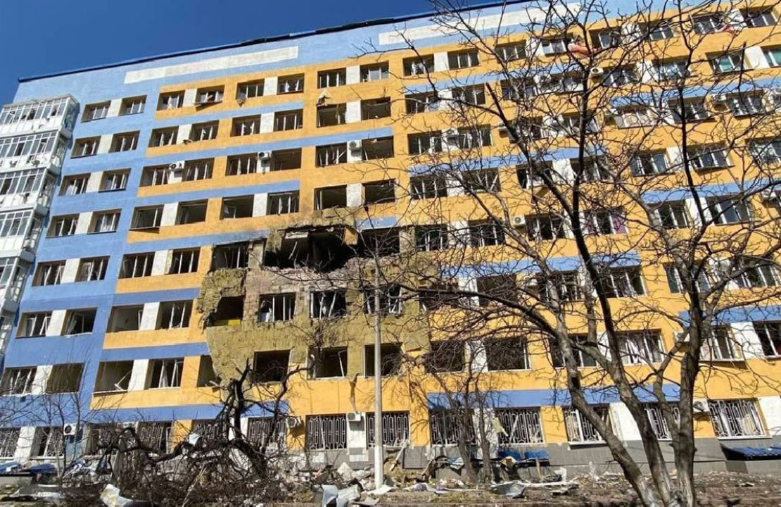
Over 4,800 buildings in our area of analysis were damaged.
Large residential apartment complexes, where tens of thousands of civilians lived before the war, appear to have been struck the most.
By May 20, 2022, 443 of the area’s 477 high-rise buildings – or 93% – had been damaged or destroyed by fighting.
At least 2,673 of the area’s 5,673 single-story structures – or 47% – were also damaged.
To assess the scale of the damage, we gathered and analyzed thousands of photographs and videos recorded by people in Mariupol. Our team did a close analysis, verifying, geolocating and preserving over 850 photographs and videos.
At the start of the project, we collected as many videos as we could, prioritizing drone footage that would give a sense of the level of destruction across Mariupol and help familiarize us with the city's general layout. Then we began collecting footage from various social media platforms, pulling them largely from Telegram, YouTube, X (formerly Twitter), and VK, as well as from news agencies.
We discovered smaller YouTube channels where individuals would document entire streets or visit addresses on behalf of requests made by people in the comment sections. One Telegram account called Mariupol Now posted thousands of images and videos of the damage to buildings, tagging exact addresses.1 These sources, in addition to photos and videos shared by witnesses, were indispensable for our research.
Documenting the Destruction
During the first days of the fighting, videos and photographs recorded in Mariupol were unique visual sources because cloud cover made satellite imagery analysis difficult. Only signs of sporadic, single attacks were visible from the sky.
When the clouds lifted around the second week of March, the satellite imagery showed the extent and scale of the devastation during the first weeks of the battle.

This also confirmed that some buildings were hit more than once.
The footage we verified from social media was essential to show damage to the facades of large residential apartment complexes. This was especially important for the northern-facing facades of buildings that were frequently obscured by shadows on satellite imagery, due to the time and angle at which these images were captured.


There were fewer videos and photographs available showing free-standing houses and cottages in our area of analysis. We largely used satellite imagery to detect structural damage, like damage to rooftops, to these buildings.
Satellite imagery combined with locally recorded footage helped us create a deeper assessment of damage to buildings. This helped us understand that, in some instances, while the facades or rooftops of some apartment buildings had not been severely damaged, many had been engulfed in flames, making them dangerous and uninhabitable.
Civilian Infrastructure
Damage to Schools and Universities
Nearly every school and university campus in our area of analysis showed signs of damage. We then expanded our analysis to the whole of the city to understand the full extent of damage to Mariupol’s civilian infrastructure.
Civilian Infrastructure
Damage to Hospitals
Loss of Electricity and Water
We obtained and analyzed power line register dispatches from the largest private energy company in Ukraine, DTEK.2 These dispatches contained information about when electrical substations lost power supply.
The timeline shows that 19 substations within the city of Mariupol went offline between February 25 and March 2, 2022, various groups on various dates. This suggests that the damage happened to powerlines that connect transformer stations to groups of substations.
These incident reports confirmed that damage to electrical powerlines also affected the functionality of filtering and water stations. This made them non-operational and deprived the people of Mariupol of clean drinking water and sanitation.
The city of Mariupol remained in the dark and without water for many months.
Demolition
Remaking the City in Russia’s Image
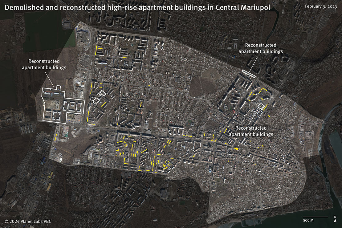
Many of these damaged and uninhabitable buildings are now gone. Entire neighborhoods—in particular in the Livoberezhnyi district on the left bank of Mariupol—have been demolished since Russian forces occupied the city.
In our area of analysis, a total of 66 buildings had been demolished as of February 9, 2023, while nearly 150 had been marked for demolition by the “DNR.” Demolitions continued into 2023. Citywide, 447 buildings in Mariupol were on an official “DNR” demolition list circulated on social media as of March 31, 2023.
Call to Action
Take a Stand for Human Rights in Ukraine:
Research, United, Advocate!
Join us to make a difference in Ukraine’s war-torn landscape. Research, collaborate, and engage with human rights organizations. Together, we can protect and promote human rights.
1 Mariupol Now (@mariupolnow), https://t.me/mariupolnow (accessed November 14, 2023).
2 Home Page, DTEK, https://dtek.com/en/ (accessed September 4, 2023).
3 “Flash Update on WASH situation in the Donetsk Oblast, 27/02/2022,” UNICEF and Water, Sanitation and Hygiene (WASH) Cluster, February 27, 2022, https://reliefweb.int/report/ukraine/wash-cluster-flash-update-wash-situation-donetsk-oblast-27022022 (accessed July 12, 2023); “WASH Cluster Incident Report No 299, 02/03/2022,” UNICEF and Wash Cluster, March 3, 2022, https://reliefweb.int/report/ukraine/wash-cluster-incident-report-299-02032022 (accessed July 12, 2023).
4 Ukraine: Water, Sanitation and Hygiene, ReliefWeb Response, https://response.reliefweb.int/ukraine/water-sanitation-and-hygiene (accessed July 12, 2023).