I. SUMMARY
These houses should have been demolished and evacuated a long time ago Three hundred meters of the Strip along the two sides of the border must be evacuated Three hundred meters, no matter how many houses, period.
Major-General Yom-Tov Samiya,
former head of IDF Southern Command[1]
I built homes for Israelis for 13 years.I never thought the day would come when they'd destroy my house. They destroyed the future.How can I start all over now?
Isbah al-Tayour, Rafah resident,
former construction worker in Israel[2]
Over the past four years, the Israeli military has demolished over 2,500 Palestinian houses in the occupied Gaza Strip.[3]Nearly two-thirds of these homes were in Rafah, a densely populated refugee camp and city at the southern end of the Gaza Strip on the border with Egypt.Sixteen thousand people, more than ten percent of Rafah's population have lost their homes, most of them refugees, many of whom were dispossessed for a second or third time.[4]
As satellite images in this report show, most of the destruction in Rafah occurred along the Israeli-controlled border between the Gaza Strip and Egypt.During regular nighttime raids and with little or no warning, Israeli forces used armored Caterpillar D9 bulldozers to raze blocks of homes at the edge of the camp, incrementally expanding a "buffer zone" that is currently up to three hundred meters wide.The pattern of destruction strongly suggests that Israeli forces demolished homes wholesale, regardless of whether they posed a specific threat, in violation of international law.In most of the cases Human Rights Watch found the destruction was carried out in the absence of military necessity.
In May 2004, the Israeli government approved a plan to further expand the buffer zone, and it is currently deliberating the details of its execution.The Israeli military has recommended demolishing all homes within three hundred meters of its positions, or about four hundred meters from the border.Such destruction would leave thousands more Palestinians homeless in one of the most densely populated places on earth.Perhaps in recognition of the plan's legal deficiencies, the Israel Defense Forces (IDF) are not waiting for the government to approve the plan.Ongoing incursions continue to eat away at Rafah's edge, gradually attaining the desired goal.
This report documents these and other illegal demolitions.Based on extensive research in Rafah, Israel, and Egypt, it places many of the IDF's justifications for the destruction, including smugglers' tunnels and threats to its forces on the border, in serious doubt.The pattern of destruction, it concludes, is consistent with the goal of having a wide and empty border area to facilitate long-term control over the Gaza Strip.Such a goal would entail the wholesale destruction of neighborhoods, regardless of whether the homes in them pose a specific threat to the IDF, and would greatly exceed the IDF's security needs.It is based on the assumption that every Palestinian is a potential suicide bomber and every home a potential base for attack.Such a mindset is incompatible with two of the most fundamental principles of international humanitarian law (IHL): the duty to distinguish combatants from civilians and the responsibility of an Occupying Power to protect the civilian population under its control.
This report also documents-through witness testimony, satellite images, and photographs-the extensive destruction from IDF incursions deep inside Rafah this past May. In total, the IDF destroyed 298 houses, far more than in any month since the beginning of the Palestinian uprising four years ago.The extent and intensity of this destruction was not required by military necessity and appears intended as retaliation for the killing of five Israeli soldiers in Rafah on May 12, as well as a show of strength.
Israeli Prime Minister Ariel Sharon's plan to "disengage" from the Gaza Strip holds little hope of relief to the residents of Rafah.Under the plan, the IDF will maintain its fortifications and patrols on the Rafah border indefinitely.The plan explicitly envisions the possibility of further demolitions to widen the buffer zone on the basis of vague "security considerations" that, as this report demonstrates, should not require a buffer zone of the kind that currently exists, let alone further mass demolitions.
This report recommends that the Israeli government cease its unlawful demolitions, allow displaced Palestinians to return, pay reparations to victims, pay to repair unlawful damage, and address the emergency needs of the displaced.The international community, which funded some of the infrastructure destroyed by the Israeli military and continues to pay for emergency relief, should press Israel to take these steps.In the meantime, if donors allocate funds to rehouse victims and repair unlawful destruction, they should demand compensation from Israel.
A Pattern in the Rubble
The Israeli military argues that house demolitions in Rafah are necessary primarily for two reasons: to deal with smuggling tunnels from Egypt that run underneath the IDF-controlled border and to protect IDF forces on the border from attack.Rafah is the "gateway to terror," officials say the entrance point for weapons used by Palestinian armed groups against the Israeli military and civilians.Under international law, the IDF has the right to close smuggling tunnels, to respond to attacks on its forces, and to take preventive measures to avoid further attacks.But such measures are strictly regulated by the provisions of international humanitarian law, which balance the interests of the Occupying Power against those of the civilian population.
In the case of Rafah, it is difficult to reconcile the IDF's stated rationales with the widespread destruction that has taken place.On the contrary, the manner and pattern of destruction appears to be consistent with the plan to clear Palestinians from the border area, irrespective of specific threats.
Tunnels
The IDF argues that an extensive network of smuggling tunnels from Egypt require incursions into Rafah that result in house demolitions.According to the IDF, a typical tunnel-hunting operation requires Israeli forces to destroy a house covering a tunnel exit as well as houses from which Palestinian gunmen fire at them during the operation.
Based on interviews with the IDF, Rafah residents, the Palestinian National Authority (PNA), members of Palestinian armed groups, and independent experts on clandestine tunnels, Human Rights Watch concludes that the IDF has consistently exaggerated and mischaracterized the threat from smuggling tunnels to justify the demolition of homes.There is no dispute that tunnels exist to smuggle contraband, including small arms and explosives used by Palestinian armed groups, into the Gaza Strip.But despite the tremendous burden that demolitions have imposed on the civilian population, the IDF has failed to explain why non-destructive means for detecting and neutralizing tunnels employed in places like the Mexico-United States border and the Korean demilitarized zone (DMZ) cannot be used along the Rafah border.Moreover, it has at times dealt with tunnels in a puzzlingly ineffective manner that is inconsistent with the supposed gravity of this longstanding threat.The report makes three main points:
- Shafts vs. Tunnels.Israeli officials claim to have uncovered approximately ninety tunnels in Rafah since 2000, giving the impression of a vast and burgeoning underground flow of arms into Gaza.When pressed about these claims, the IDF admitted the figure refers to tunnel entrance shafts, some of which connect to existing tunnels and others of which connect to nothing at all.Rather than digging new tunnels, an IDF spokesman told Human Rights Watch, smugglers are often trying to connect to cross-border tunnels that already exist.This is possible in part because, until 2003, the IDF did not seek to close the tunnels themselves, but merely demolished the Rafah homes in which tunnel entrance shafts operative or inoperative were found.This tactic caused much destruction and homelessness while leaving tunnels largely intact.Soldiers have been venturing inside tunnels since 2003, though an IDF spokesman told Human Rights Watch that the military does not have the technology to collapse lateral portions of tunnels.In response to an inquiry from Human Rights Watch, the IDF refused to specify how many tunnels versus entrances had been discovered and destroyed.The IDF's approach namely, the use of ineffective methods for two years, followed by unclear improvements contrasts sharply with alarmist Israeli statements on tunnels and the flow of arms.
- Inoperative Tunnels.In at least three cases, the IDF has destroyed houses containing inoperative tunnels.In July 2004, residents discovered and reported to the PNA an incomplete shaft in an empty house.A few days later, the IDF destroyed the house and seventeen other houses nearby, leaving 205 people homeless as well as a factory.Human Rights Watch's onsite assessment just after the incursion, as well as interviews with eyewitnesses and a representative of a Palestinian armed group, indicated that the destruction was militarily unnecessary; even in the home with the tunnel entrance, demolition of the whole house was an excessive response to an incomplete shaft that could have been effectively sealed with concrete.Human Rights Watch documented two other cases in which the IDF appears to have destroyed houses with tunnel shafts that had already been sealed by the PNA.The IDF claims that PNA closures are incomplete.
- Alternatives to Home Demolition.According to tunnel experts consulted by Human Rights Watch, a number of less destructive alternatives exist for the effective detection and destruction of smuggling tunnels.No one method is guaranteed to work in all situations, but different techniques can compensate for each other's shortcomings, and overall conditions in Rafah favor the IDF: Only four kilometers of the border run alongside Rafah, and tunnel depth is limited by the water table approximately forty-five meters in the camp.In this environment, the IDF could install an array of underground seismic sensors along the border.Known as an "underground fence," this method has successfully detected digging activity on the U.S.-Mexico border.Other methods, such as electromagnetic induction and ground-penetrating radar, could be used to detect tunnels at the point where they cross the IDF-controlled border, and detection is more likely if the tunnels contain electrical wires, lights, and pulley mechanisms, as the IDF claims. Once the IDF detects tunnels underneath the border, it could dig down and neutralize them with concrete or explosives, obviating the need for incursions into Rafah that result in destroyed homes and sometimes loss of life.
Israel in all likelihood has access to such sophisticated technology, either domestically or through the U.S. government, its closest ally.But the IDF insists it has exhausted all alternatives, and that the current tactics are the only effective way of dealing with the tunnel threat.Despite three requests from Human Rights Watch, the IDF declined to explain the alternative methods it has attempted to detect tunnels and why they did not work.While some information regarding tunnels may be sensitive, the enormous impact on the civilian population of demolitions places the burden on Israel to make the case as to why the only way of dealing with tunnels that run underneath IDF positions is to demolish houses deeper and deeper into the camp.
Protecting the Border
Rafah is one of the most violent areas in the OccupiedPalestinianTerritory (OPT). Over the past four years, the IDF and Palestinian armed groups have regularly exchanged fire at various points along the border.What follows is a brief description of the fighting on the border rather than a chronology of how it unfolded.
IDF positions fire with large caliber machine guns and tanks at civilian areas.Based on multiple visits to the area by Human Rights Watch since 2001 and interviews with local residents and foreign diplomats, aid workers, and journalists, this shooting appears to be largely indiscriminate and in some cases unprovoked.In July 2004, nearly every house on Rafah's southern edge was pockmarked by heavy machine gun, tank, and rocket fire on the side facing the border.Bullet holes were not only clustered around windows or other possible sniper positions, but sprayed over entire sides of buildings.Human Rights Watch researchers also witnessed indiscriminate use of heavy machine gun fire against Palestinian civilian areas in nearby Khan Yunis, without apparent shooting by Palestinians from that area at the time.
On a regular basis, IDF positions and patrols on the border come under attack from Palestinian armed groups using small arms and rocket-propelled grenades.During three nights in July Human Rights Watch researchers spent in Rafah, Palestinian small arms fire was sporadic while IDF heavy machine guns fired long bursts into the camp.
Representatives of Palestinian armed groups in Rafah told Human Rights Watch that the IDF-controlled border is well-fortified and attacking it is largely in vain, especially because a single 7.62 mm bullet in Rafah costs U.S. $7 (a figure also cited by the IDF as evidence of their success in blocking arms).
Both the IDF and Palestinian armed groups use tactics that place civilians at risk.Under customary international law, civilians must be kept outside hostilities as far as possible, and they enjoy general protection against danger arising from hostilities.Human Rights Watch documented multiple cases where the IDF converted civilian buildings into sniper positions during incursions and forced residents to remain with them inside.In some cases, the IDF coerced civilians to serve as "human shields" while searching Palestinian homes, a practice strictly prohibited by international humanitarian law.[5]By attacking the IDF from within populated areas, Palestinian armed groups also place civilians at risk, but Human Rights Watch found no evidence that gunmen fire from inhabited homes or force residents to let armed groups use their homes.
Despite the intense daily gunfire, most homes at the edge of the camp are still inhabited, at least part of the time. Some residents remain despite the risk, lest the IDF consider their homes abandoned and target it for destruction.Even when they do leave, however, absence does not constitute abandonment, especially when indiscriminate IDF shooting forces civilians to flee.One Palestinian, living in the municipal stadium after the IDF bulldozed two of his homes in 2001 and 2004, explained how IDF tactics force Palestinians near the border to leave their homes. "If [the Israelis] want to make you leave the home, they shoot the walls, they shoot the windows," he said."Then they can come and say 'It is empty,' and bulldoze the house."[6]
Comprehensive statistics on combatant and civilian deaths are unavailable and there is no consensus on how many Palestinian casualties from IDF fire are civilians.The IDF does not appear to keep statistics of civilian deaths or injuries inflicted by its forces. According to the Palestinian Central Bureau of Statistics, 393 residents of the Rafah governorate were killed between September 29, 2000, and August 31, 2004, including ninety-eight children under age eighteen.[7]The lowest possible percentage of civilian victims in Rafah is twenty-nine, which is the percentage of women and children killed over the past four years.The actual figure is undoubtedly much higher because twenty-nine percent presumes that every adult Palestinian male killed was directly participating in hostilities.In the same period, Palestinian armed groups killed ten Israeli soldiers in Rafah.One was killed while patrolling the border, in February 2001; four others were killed during incursions inside the camp.The other five soldiers were killed on May 12, 2004, when Islamic Jihad fighters destroyed an Israeli armored vehicle with a rocket-propelled grenade.[8]The IDF invoked this latter incident to justify the further expansion of the buffer zone through wholesale demolition of homes.As discussed below, it better demonstrates the effects of the IDF's expansive notion of security.
In this context, the IDF has taken steps that go far beyond what international law allows and what the security of its forces requires.The IDF has built improved fortifications on the border that by themselves would contribute greatly to the protection of patrols; but these new fortifications were placed deeper inside the demolished area, bringing them closer to the houses, and effectively creating a new starting point for demolitions.The IDF's expansive notion of security erodes the spirit of international humanitarian law and is a recipe for ongoing demolitions.
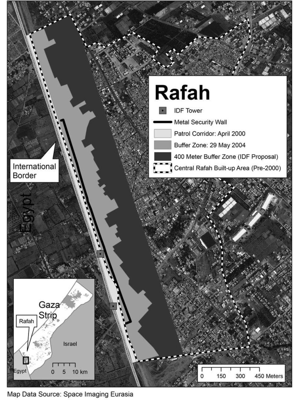
The border between the Gaza Strip and Egypt is 12.5 kilometers long, of which four kilometers run alongside Rafah.The IDF refers to this border area as the "Philadelphi" corridor or zone, but it is better understood as two distinct areas: a shielded patrol corridor (between the border and IDF fortifications) and a buffer zone (the space between IDF fortifications and the houses of Rafah).The expansion of both of these areas is illustrated in the satellite imagery included in this report.
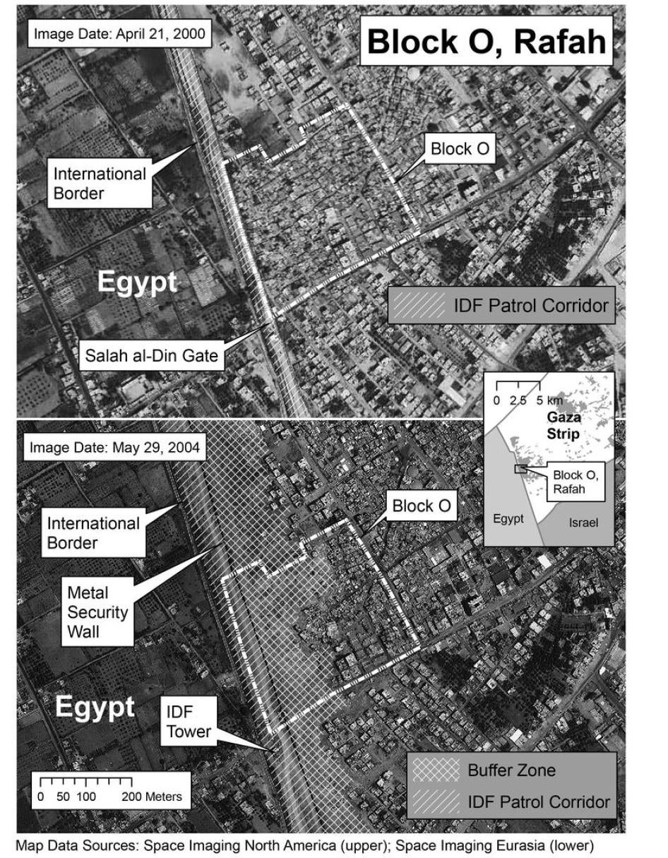
Before the uprising, the IDF maintained a patrol corridor along the border some twenty to forty meters wide, separated from the camp in most places by a concrete wall, approximately three meters high, topped with barbed wire.In some areas, especially the densely populated Block O section of the camp, houses were situated within several meters of the patrol corridor.
Beginning in 2001, as armed clashes erupted in the border area, the IDF launched nighttime raids in Block O and other areas of Rafah, demolishing up to one or two dozen homes in each attack and expelling all residents from the cleared area.The IDF argued that these demolitions were necessary responses to attacks from Palestinian armed groups, as well as part of anti-tunneling efforts.These demolitions resulted in a de facto buffer zone between the patrol corridor and the camp, littered with rubble and empty of Palestinians.
By late 2002, after the destruction of several hundred houses in Rafah, the IDF began building an eight meter high metal wall along the border.This wall, now 1.6 kilometers long, faces the parts of Rafah that used to be closest to the border.Such a structure would have greatly enhanced the security of IDF patrols by allowing armored vehicles to patrol without being seen by Palestinian snipers, while fortified IDF towers in the patrol corridor and built along the wall could monitor and respond to attacks on the wall from Rafah.Other security measures permitted under international law, such as restricting access to areas near the wall or taking control of property[9] along it (i.e. seizing homes and closing them off in a reversible manner), could have supplemented these moves.Instead of attempting any of these measures, the IDF resorted to demolitions en masse, without warning, often in the middle of the night.
Most importantly, the IDF built the wall inside the demolished area, some eighty to ninety meters from the border.Such an expansion doubled the width of the patrol corridor and was not required to safeguard the border, as the previous twenty to forty meter-wide patrol corridor was amply wide enough for multi-lane use by armored vehicles. The IDF's Merkava tank is 3.72 meters wide, while Caterpillar D9 armored bulldozers, used in demolition operations, are 4.58 meters wide without armor.
The expansion of the patrol corridor brought IDF fortifications closer to the camp, exposing them to risks subsequently invoked to justify further demolitions.According to satellite imagery taken in May 2004, some two hundred meters of demolished houses separated the metal wall from the last rows of remaining houses.In total, some fifteen percent of central Rafah's pre-2000 built-up area has been razed in order to make way for the expansion of both the patrol corridor and the buffer zone.The IDF invoked the death of five Israeli soldiers in Rafah on May 12, 2004, to demonstrate the need for a wider buffer zone.This incident instead illustrates the effects of Israel's inherently expansive notion of security: the armored vehicle carrying the soldiers was conducting an anti-tunneling operation between the metal wall and the camp, not inside the patrol corridor.
According to this logic, the IDF could continue to relocate its positions progressively closer to homes and then destroy them for security purposes.This explains in part why the rate of house demolitions in Rafah tripled in 2003 compared to the previous two years, after the completion of the wall, even though it should have reduced the perceived need to protect the border.Similarly, the IDF's recommendations for further razing are based in part on the perceived need to safeguard a proposed anti-tunneling trench in the buffer zone.While such a trench in theory could be lawful, it cannot be invoked as a reason to further expand the buffer zone, especially in light of the existence of less destructive methods to detect and neutralize tunnels.
This inherently expansive notion of "security" is incompatible with Israel's duty as an Occupying Power to balance its own interests against those of the civilian population.As one IDF officer put it, "I have no doubt that the clearing actions [i.e. house demolition and land razing] have an element of tactical value, but the question is, where do we draw the line?According to that logic, what prevents us from destroying Gaza?"[10]
Rampage in Rafah: May 2004
In May 2004, Rafah witnessed a level of destruction unprecedented in the current uprising, resulting in 298 demolished homes.After Islamic Jihad destroyed the armored personnel carrier (APC) on May 12, the IDF launched a two-day incursion to recover the soldiers' remains.IDF tanks and helicopters also led an assault on Block O, reportedly killing fifteen Palestinians, including one fifteen-year-old. Six others were identified as combatants.[11]Claiming that it came under intense fire during the entire operation, the IDF razed eighty-eight homes in Block O and neighboring Qishta area, including houses that had been separated from the buffer zone by three or four rows of homes and could not have been used to fire at the APC or the recovery teams.Towards the end of the incursion, two Israeli soldiers in Qishta were killed by Palestinian snipers.
From May 18-24, the IDF conducted a major assault called "Operation Rainbow" that penetrated deep into two areas of Rafah Tel al-Sultan in the northwest and the Brazil and Salam neighborhoods in the east reportedly leaving thirty-two Palestinian civilians dead, including ten people under age eighteen, as well as twelve armed men.The IDF also destroyed 166 houses.The offensive was ostensibly aimed at searching for smuggling tunnels, killing or arresting suspects, and eliminating "terrorist infrastructure."The IDF claimed to have discovered three smuggling tunnels during the operation, though later admitted that one of these was an incomplete shaft and another was outside of Rafah and not linked to any house demolitions.
In investigating the events of May 2004 and other demolitions, Human Rights Watch documented systematic violations of international humanitarian law and gross human rights abuses by the Israeli military.During the major May incursions of May 18-24, the IDF destroyed houses, roads, and large fields extensively without evidence that the destruction was in response to absolute military needs, including in areas of Rafah far from the border.In areas of Brazil further from the border, where incursions were not expected, most of the residents were inside their homes as armored Caterpillar D9 bulldozers crashed through the walls.Bulldozers allowed residents to flee but proceeded with the destruction before they could remove their belongings.In some cases away from the border, like the Rafah zoo, the destruction took place after the IDF had secured the area, in a manner that was time-consuming, deliberate, and comprehensive, rather than in the heat of battle.
The IDF claims its forces came under attack from Palestinians using anti-tank weapons, explosives, and small arms.Based on interviews with thirty-five Rafah residents and two members of Palestinian armed groups, information provided by the IDF, public statements by Palestinian armed groups and the Israeli government, and after surveying the affected areas, Human Rights Watch believes that armed Palestinian resistance to the May 18-24 operation was light, limited, and quickly overwhelmed within the initial hours of each incursion.Both sides made tactical choices to maximize their respective advantages: the IDF limited their operations mostly to Brazil and Tel al-Sultan, where they were not expected and Palestinian armed groups laid ambushes in the densely populated heart of the original camp, where they would be more likely to engage the IDF at close quarters.The main streets in Tel al-Sultan and Brazil are relatively wide and arranged in grid-like patterns.The Israeli government designed them in this way during the 1970s to facilitate the movement of its forces and limit cover for Palestinian gunmen.As a result, throughout the operation there was minimal direct engagement between the IDF and Palestinian armed groups. This contrasts sharply with the fierce multi-day battle in the densely populated heart of Jenin refugee camp in April 2002, which resulted in the death of fifty-two Palestinians, including twenty-seven confirmed civilians and thirteen IDF soldiers.
During the incursions into Tel al-Sultan and Brazil, the IDF employed armored Caterpillar D9 bulldozers in a manner that was indiscriminate and excessive, resulting in widespread destruction of homes, roads, and agriculture that could have been avoided:
- Houses.In Brazil, Caterpillar D9 bulldozers cleared "tank paths" inside the camp by plowing through blocks of houses as a general precaution against possible attacks with RPGs or roadside bombs, irrespective of the specific threats that international law requires.The IDF also used D9s to destroy homes near suspected smuggling tunnels and in other areas on a preventive basis, not in response to specific threats.Other house demolitions had no discernible reason.
- Road destruction.In both Tel al-Sultan and Brazil, the IDF used Caterpillar D9s to indiscriminately tear up roads, destroying water and sewage networks, and creating a significant public health risk in an already vulnerable community.In some areas, water shortages forced residents to leave their homes in search of water, putting them at risk of being shot by IDF snipers for breaking curfew.In total, the IDF destroyed fifty-one percent of Rafah's roads, usually by dragging a blade known as the "ripper" from the back of the D9 down the middle of the road.The IDF gave various explanations for this tactic, including the need to clear paths of potential bombs (improvised explosive devices, or IEDs), to sever wires that could be used to detonate explosive devices and to prevent suicide car attacks on Israeli forces. If the IDF was truly concerned about wires and IEDs, it would have used a front mounted device. Instead they used rear-mounted rippers that afforded no protection for the D9 bulldozers or their drivers fromexplosive devices in the road.In addition, as a photograph in Chapter 6 taken from another incursion shows, the ripper creates a path of debris down the middle of the road, leaving side lanes intact for use by suicide car attacks.Tearing up paved roads also creates loose debris that facilitates the concealment of explosives and booby-traps.
- Razing Agricultural Land.The IDF razed two large tracts of agricultural land outside the Tel al-Sultan housing project away from the border.Such destruction after the IDF had secured the area was disproportionate to any potential military gain and had a harmful impact on an area where agricultural production plays an important role.The IDF told Human Rights Watch that military vehicles destroyed agricultural land because they had to avoid booby-traps on roads, but this does not explain why bulldozers spent more than two days systematically destroying two large fields of greenhouses.
While research focused on the extensive destruction in the Rafah camp, Human Rights Watch also documented other abuses during the incursions into Tel al-Sultan and Brazil, including unlawful killings of civilians and IDF troops coercing civilians to serve as "human shields."Most egregiously, on March 19, an Israeli tank and helicopter opened fire on a demonstration, killing nine, including three children under age eighteen.The IDF did not claim that its troops had come under fire, only that gunmen were in the crowd; eyewitness accounts and video evidence contradict this.In response to an inquiry from Human Rights Watch, the IDF said that one those killed had been listed in its records as a "Hamas activist" but did not substantiate or even reaffirm the claim that he had been armed at the time.
Doctrines of Destruction
As the Occupying Power in the Gaza Strip, the IDF has two roles: an administrator with police and security powers, and a potential belligerent who may engage in fighting.But at all times it is responsible for protecting the civilian population, in accordance with both international humanitarian law (the laws of armed conflict) and human rights law.
International humanitarian law permits an occupier to take the drastic step of destroying property only when "rendered absolutely necessary by military operations."[12]According to the International Committee of the Red Cross (ICRC), military operations are "movements, manuvres and actions of any sort, carried out by the armed forces with a view to combat."[13]A belligerent occupation cannot be considered a "military operation" in itself, nor can every activity conducted by the Occupying Power be considered a military operation; rather, a military operation must have some concrete link to actual or anticipated fighting.Destroying property to improve the general security of the occupier or as a broad precaution against hypothetical threats is prohibited.As the ICRC stated during the May incursions in Rafah, "the destruction of property as a general security measure is prohibited."[14]Even during military operations, indiscriminate and disproportionate attacks on civilian objects are not allowed.Civilian property may not be destroyed unless it is making an effective contribution to military action and its destruction offers a definite military advantage.In cases in which the targeted object is normally dedicated to a civilian purpose, such as a house, the presumption under the law is that it is not a legitimate target.
Outside of combat, the Occupying Power may take measures to enhance its security.Among other things, it can temporarily take control of property to prevent its hostile use, build fortifications, and prohibit access to certain areas, but these measures must be compatible with a fuller range of human rights protections, including the right to compensation for properties seized.Although it has denied the applicability of international human rights instruments to Palestinians in the OPT, Israel is widely considered to be bound by these laws.International human rights law obliges Israel to provide effective judicial remedies for victims of forced eviction and to ensure adequate housing for Palestinians
The IDF's unlawful policy of destruction is consistent with public statements by Israeli officials, the IDF's disturbingly permissive interpretation of international law, and its own admission that destruction has been excessive:
- The IDF has publicly admitted destroying houses to "weaken the fear of tunnels"[15] or in response to other hypothetical risks.This doctrine conflates the legal requirement of absolute military necessity a strict standard requiring that any property destruction must be connected to combat with the much broader notion of security.This conflation is consistent with the expressed desire of senior IDF officers, from Sharon's days as head of the IDF Southern Command in the early 1970s[16] through Yom-Tov Samiya's statements quoted at this summary's beginning, to raze all homes near the border.
- The IDF's military manual misinterprets international law to permit destruction even when it violates the laws of armed conflict, a standard that is far more permissive than that of other major militaries.According to the IDF manual, "The Hague Conventions state that unnecessary destruction of enemy property is forbidden. The only restriction is to refrain from destroying property senselessly, where there is no military justification, for the sheer sake of vandalism."[17]The IDF manual does not mention that military necessity is commonly understood among major militaries to exclude actions that are expressly prohibited by the rules of IHL, since military necessity was incorporated into the formulation of those rules.[18]The manual also does not require that property destruction be absolutely necessary or that it conform to fundamental principles of IHL, such as the duty to refrain from indiscriminate or disproportionate attacks.The IDF manual is far more permissive than, for example, the U.S. and Canadian military manuals, which require some connection between destruction and the overcoming of enemy forces.[19]
- Senior IDF officers have admitted that not all property destruction is authorized or justified in such operations.After the IDF destroyed approximately sixty houses in Block O in January 2002, Major-General Doron Almog, then head of the Southern Command, announced that some of the houses had been inadvertently destroyed due to "navigational errors."[20]Brigadier-General Dov Zadka told the press on one occasion that he had approved a particular scope of "clearing," only to find that troops had exceeded the approved amount."You approve the removal of thirty trees, and the next day you see that they removed sixty trees," he said.[21]Even if these were mistakes, compensation and/or reparation should be made in such cases.Despite this, the IDF has apparently not investigated any cases of improper or unlawful house demolitions.
Rafah is not the only place where the IDF has extensively destroyed property in the name of security.Throughout the Gaza Strip, Israeli forces have created buffer zones near IDF bases, illegal settlements, and Israeli-only bypass roads by systematically leveling houses and agricultural fields.[22]
For decades, the IDF has demolished homes for various reasons.Most prominent have been punitive or "deterrent" demolitions aimed at the family homes of Palestinians engaged or suspected of engaging in armed activities.Such collective punishments are strictly forbidden by international humanitarian law.[23]Israeli authorities have also destroyed Palestinian houses in the West Bank and Israel ostensibly for violating building code regulations.These demolitions are not the focus of this report but have been extensively addressed elsewhere.[24]
Nowhere to Turn
Palestinians in the OccupiedPalestinianTerritories (OPT) have nowhere to turn in Israel for legal protection against unlawful demolitions and forced evictions.The IDF, the Supreme Court, and the Knesset have all played a role in denying effective remedies.
An IDF spokesman and an IDF legal officer told Human Rights Watch that they had no knowledge of any investigations into cases of unlawful or improper house demolition,[25] even though the IDF military police had opened 173 investigations of damage to property in the OPT as of May 2004 (thirty-four percent of the total number of investigations opened in the OPT).[26]The Israeli Supreme Court has consistently sanctioned IDF policies that violate international law, including house demolitions aimed at collectively punishing families of militants and those destroyed to make way for the illegal "separation barrier" under construction inside the occupied West Bank.[27]And under Israeli law, compensation is ruled out in cases of "combat activity," which the Knesset amended in 2002 with an expansive definition that includes virtually every IDF action in the OPT.
The international community has forcefully condemned unlawful destruction in Rafah and elsewhere in the OPT.But donors who have invested heavily in Gaza, including in infrastructure and facilities destroyed by the IDF, have found themselves entangled in a dilemma.On the one hand, the knowledge that international aid money will pay to reconstruct what has been destroyed is likely to fuel the IDF's sense of impunity for unlawful destruction.On the other hand, donors know that restricting or reducing aid would harm Palestinian victims.Under international law, Israel is responsible for unlawful damage caused by its forces and cannot misuse aid meant for Palestinians to evade its own obligations.As such, Human Rights Watch recommends that the international community press Israel to either pay reparations to victims or to compensate donors directly for any funds spent on repairing unlawful destruction.
Methodology
A Human Rights Watch team of three researchers spent a combined total of one month in the Gaza Strip, Israel, and Egypt to research this report.The team interviewed over eighty individuals, including thirty-five residents of Rafah who were victims of and/or eyewitnesses to house demolitions or other abuses, corroborating and cross-checking their accounts.Researchers also spoke to first-hand participants in and observers of events in Rafah, including representatives of two Palestinian armed groups, Palestinian National Authority security personnel, and municipal officials.Representatives of international relief organizations and local human rights groups in GazaCity also provided information.
In Israel, the researchers met with three representatives of the IDF and an official from the Israeli Ministry of Foreign Affairs, as well as foreign diplomats, military specialists, local and international journalists, and local human rights organizations.The IDF shared information about its operational and legal doctrines, as well as its unclassified assessments of the Rafah border situation.In Egypt, researchers met with officials from the Egyptian Interior Ministry, local activists, and journalists.The research also included analysis of public statements by Israeli government entities and Palestinian armed groups.
Human Rights Watch also conducted on-site examination of physical evidence in Rafah, including ballistics, especially in cases of recent demolitions.In all cases, researchers recorded the precise Global Positioning System (GPS) coordinates of locations visited, including those of demolished houses, using handheld GPS devices.The geospatial data has been incorporated into the maps and satellite images in this report.Researchers took hundreds of digital photographs, some of them reproduced in this report, and were given access to extensive photographs and video taken by local journalists and human rights organizations during the May 2004 incursions.
In analyzing the broader patterns of destruction, Human Rights Watch was aided by satellite imagery of Rafah taken since 2000 and provided by Space Imaging North America, Space Imaging Eurasia, Space Imaging Middle East, and DigitalGlobe.Human Rights Watch also drew on detailed statistical data on house demolitions compiled by UNRWA and the Palestinian Centre for Human Rights (PCHR).
Map 1: Gaza Overview
II. RECOMMENDATIONS
To the Government of Israel
- Cease all property destruction that is not absolutely necessary to the conduct of hostilities, including all punitive ("deterrent") destruction.Prohibit attacks against property on the basis of mere suspicion or hypothetical risk rather than absolute military necessity.
- Repudiate plans to widen the border ("Philadelphi") buffer zone, including in the event of "disengagement" from the Gaza Strip.
- Allow general return of residents to demolished areas, including in de facto buffer zones.Ensure that any restrictions on return are proportionate in impact and duration, regularly re-evaluated and implemented only when and to the extent necessary, open to challenge before an impartial court, and accompanied by provisions for adequate housing.
- Ensure that any use of armed force, especially along the Rafah border or around other Israeli bases, is proportionate and discriminate.Ensure that open fire regulations issued to members of the Israel Defense Force in border fortifications comply with the U.N. Basic Principles on the Use of Force and Firearms by Law Enforcement Officials and the U.N. Code of Conduct for Law Enforcement Officials.
- Investigate and hold accountable all members of the IDF and their superiors found to have destroyed, or tolerated the destructions of, homes or property in violation of international humanitarian law.
- Pay reparations and full compensation to owners of unlawfully demolished homes.If funds for repairing unlawful damage caused by the IDF are allocated by international donors, compensate donors directly.
- Ensure that any control of property for security reasons is fully consistent with both international human rights standards and international humanitarian law.Control of property should be used only when and to the extent necessary, should not amount to confiscation, and should be open to challenge before an impartial court.
- Maintain accurate statistics on property damaged, make that information publicly accessible in a timely fashion, and require that such reporting be part of the operational debrief following any military operation.Such record keeping should also include the precise justification for the demolition, whether it was conducted in the course of combat activities, and the specific incidents that led to that demolition or property destruction.
- Repeal the 2002 amendment to the Torts (State Liability) Law to allow individuals whose property has been wrongfully damaged in IDF operations to claim compensation.
- Cease immediately the practice of using lethal force to enforce mass house arrest or curfew.
- Cease immediately the practice of indiscriminately destroying roads, as well as associated destruction of infrastructure.
- Cease immediately the coerced use of civilians to assist IDF military operations.
- To the maximum extent feasible, avoid locating military objectives within or near densely populated areas.Take all necessary precautions to protect the civilian population, individual civilians and civilian objects under IDF control against the dangers resulting from military operations.
- Allow immediate access to, and cooperate fully with, the human rights special mechanisms of the United Nations as well as other independent international investigators, to investigate allegations of human rights violations since the beginning of the uprising on September 29, 2000.
- Explain why the IDF is not using less destructive methods of neutralizing tunnels.
To the Palestinian National Authority
- Instruct the law enforcement agencies of the PNA to take all possible steps, in accordance with internationally accepted human rights norms, to identify and bring to justice anyone who incites, plans, assists, or attempts to carry out attacks against civilians.
- Take all possible steps to restrict the flow of arms used in attacks against civilians.
- Discourage Palestinian armed groups from launching attacks from civilian areas.
- Map accurately and comprehensively the exact location, nature, and value of properties and agricultural land destroyed by the IDF.
To Palestinian armed groups in Rafah
- Cease deliberate attacks against civilians and civilian targets.
- Cease use of inherently indiscriminate weapons.These include rockets that cannot be aimed and victim-activated explosive devices such as booby-traps.
- To the maximum extent feasible, avoid launching attacks from areas populated by civilians or locating military objectives within or near densely populated areas.Take all necessary precautions to protect the civilian population control against the dangers resulting from armed activities.
To the International Community
- Demand that the Government of Israel and the PNA implement the above recommendations.
- Insist that Israel continue to abide by its responsibilities as an Occupying Power under international humanitarian law if the partial redeployment envisioned by the "disengagement" plan is implemented.
- Monitor carefully damage to donor-funded property, projects, or infrastructure in Gaza, and ensure that compensation is paid by Israeli authorities for losses or damage caused in contravention of international law.
- Insist that Israel compensate donor governments for funds spent on repairing unlawful destruction by the IDF.
- Fully support programs aimed at ensuring the right to adequate housing of displaced Palestinians.
- Support the return of Palestinians displaced by unlawful demolitions.
- High Contracting Parties to the Geneva Conventions of 1949 should take immediate action, individually and jointly, to ensure respect for the provisions of the Fourth Geneva Convention, including prohibitions on unlawful destruction and collective punishment.
- Provide technical and material support to strengthen the investigative capacity of the PNA's law enforcement agencies including, if necessary and appropriate, through the temporary secondment of suitably qualified police investigators to work alongside Palestinian officers and to assist them in pursuing and bringing to justice those responsible for attacks against civilians.
To the Government of the United States
- Demand that the Government of Israel and the PNA take immediate steps to implement the above recommendations in both private and public communications.
- Restrict Israel's use of Caterpillar D9 armored bulldozers, Apache and Cobra helicopter gunships, and other U.S.-origin weapons systems that are used in the commission of systematic violations of international human rights and humanitarian law.
- Inform the Government of Israel that continued U.S. military assistance requires that the government take clear and measurable steps to halt its security forces' serious and systematic violations of international human rights and humanitarian law in the West Bank and Gaza Strip, as documented in this and previous Human Rights Watch reports.[28]These steps should include conducting transparent and impartial investigations into allegations of serious and systematic violations, making the results public, and holding accountable persons found responsible.
- Inform the PNA that any security assistance from the U.S. requires clear and measurable steps to halt within its power to halt serious and systematic violations of international human rights and humanitarian law in the West Bank and Gaza Strip by its security forces and by Palestinian armed groups, as documented in previous Human Rights Watch reports.[29]
- Ensure that enforcement of human rights and humanitarian law protections are not made subordinate to the outcomes of direct negotiations between the parties to the conflict.Agreements should be consistent with fundamental human rights and humanitarian norms.
To the Member States of the European Union
- Demand that the Government of Israel and the PNA take immediate steps to implement the above recommendations in both private and public communications.
- Consistent with the August 11 declaration of European Commissioner for Development and Humanitarian Aid Poul Nielson, make clear to Israel that emergency funds for reconstruction in the OPT do not absolve Israel of its responsibilities as an Occupying Power under international humanitarian law.
- Develop and make public benchmarks for compliance by the government of Israel with international human rights and international law commitments as embedded in Article 2 of the Euro-Mediterranean Association Agreement between the E.U. and its member states and Israel.
- Implement the European Code of Conduct on Arms Exports and restrict transfer to Israel of weapons found to be used in the commission of serious and systematic violations of international human rights and humanitarian law in the West Bank and Gaza Strip.
- Inform the PNA that any security assistance from the E.U. requires clear and measurable steps to halt within its power to halt serious and systematic violations of international human rights and humanitarian law in the West Bank and Gaza Strip by its security forces and by Palestinian armed groups, as documented in previous Human Rights Watch reports.
- Ensure that enforcement of human rights and humanitarian law protections are not made subordinate to the outcomes of direct negotiations between the parties to the conflict.
To Caterpillar Inc.
- Suspend sales of D9 bulldozers, parts, or maintenance services to the IDF pending the implementation of the above recommendations.
- Seek to ensure that Caterpillar's goods and services will not be used to abuse human rights, in accordance with the U.N. Norms on the Responsibilities of Transnational Corporations and Other Business Enterprises with Regard to Human Rights.
III. BACKGROUND
The Gaza Strip is a wisp of land southwest of Israel along the Mediterranean Sea.Forty-five kilometers long and ranging from five to twelve kilometers wide, it is home to some 1.2 million Palestinians, making it one of the most densely populated areas on Earth.Approximately seventy-eight percent of the Palestinian population consists of refugees, displaced in 1948 and 1949 from what is now Israel, and their descendants.
The Gaza Strip and West Bank were the two areas of the British mandate of Palestine that did not become part of the new state of Israel as a result of the 1948 Arab-Israeli war.Instead, Gaza came under Egyptian control while Jordan seized the West Bank.Israel briefly took Gaza and the Sinai peninsula during the Suez Crisis in 1956, but returned them to Egypt under international pressure.The 1967 War, however, left Israel in control of Gaza, the West Bank, the Sinai, and the Golan heights of Syria.In 1982, Israel returned the Sinai to Egypt as part of the Camp David Peace Treaty.The U.N. refers to the West Bank and Gaza Strip as the OccupiedPalestinianTerritory.
Under international law, Gaza, the West Bank, and the Golan are occupied territories, which places their populations under the protection of the Fourth Geneva Convention.Israel has long disputed the applicability of the Fourth Geneva Convention to the OPT, although it has promised to voluntarily abide by its humanitarian provisions.The rest of the international community has consistently affirmed the applicability of the Convention to the OPT and Israel's responsibilities as an Occupying Power under the Convention.[30]
Israel has continually failed to fulfill its obligations under international law as an Occupying Power.It has built, and continues to build, settlements in the West Bank and Gaza Strip reserved exclusively for Jews.Such settlements in occupied territory are illegal under international law; they violate the prohibitions of the transfer of civilians to an occupied territory[31] and the creation of permanent changes that are not for the benefit of the occupied population.After World War II, the drafters of the Fourth Geneva Convention specifically intended to prevent states from colonizing territories they occupied.[32]
According to the Oslo Accords of the 1990s, approximately forty percent of Gaza's territory is currently under direct Israeli military control, most of it inaccessible to Palestinians.[33]These areas include some twenty Israeli settlements, home to 7,500 settlers, Israel Defense Forces (IDF) bases, and exclusive by-pass roads linking these areas to each other and to Israel.[34]Areas along the Egyptian border in the south and the boundary with Israel in the north and east are also under direct Israeli military control.Israel controls all movement into and out of the Gaza Strip.
The rest of Gaza is administered by the Palestinian National Authority (PNA), headed by Yasser Arafat, as dictated by the Oslo Accords of 1994-1995. The PNA is not a sovereign state but a self-rule administration with policing powers and is subordinate to Israel in both law and practice.[35]Under the Oslo Accords, Israel retains overall security authority throughout the OPT for external defense and can take "all necessary" steps to ensure the security of both Israel and the settlements, including by taking action in areas directly administered by the PNA.[36]Agreements between an Occupying Power and local authorities cannot be used to deprive civilians of their protections under international humanitarian law.[37]
Although the PNA cannot ratify international human rights instruments, it has signaled its desire to adhere to human rights standards.Human Rights Watch considers the PNA to be bound to international human rights standards to the extent of its powers, including obligations to prevent attacks against civilians from areas under its control and to respect the human rights of individuals in its custody.The PNA has continually failed to fulfill these obligations.[38]
The PNA has no military but has several security forces, from regular police to intelligence services.There are also a number of Palestinian armed groups in the Gaza Strip which are outside of the PNA's authority and sometimes in adversarial relationships with it.Armed groups active in Gaza include the al-Aqsa Martyrs Brigade, a militant offshoot of Arafat's Fatah party, and the military wings of Hamas, Islamic Jihad, the Popular Resistance Committees, and the Popular Front for the Liberation of Palestine.In their fight against the occupation, all of these groups attack both civilian and military targets.Targeting civilians or carrying out indiscriminate attacks against them violates international humanitarian law, and Human Rights Watch has documented and condemned the practice by Palestinian armed groups.[39]
International organizations and local nongovernmental organizations (NGOs) are also involved in all aspects of Gaza life.Most important is the United Nations Relief and Works Agency (UNRWA) for Palestine Refugees in the Near East, whose mandate includes the provision of social services such as health care and education to Palestinian refugees both inside and outside officially recognized refugee camps.UNRWA also provides emergency relief.The agency's role in providing services in the Gaza Strip rivals that of the PNA, as eighty percent of Gaza's population consists of refugees.Palestinian NGOs are also very active in the fields of health care, education, and human rights.
The Uprising in Gaza: From Closure to "Disengagement"
Over the past four years, Israel has faced an armed uprising throughout the OPT, including attacks on both its military and civilians.In the Gaza Strip, the government has responded with a broad strategy of isolating the Palestinian population from Israel, strictly controlling the movement of Palestinians, while attempting to retain overall control over the territory.As explained below, the so-called "Gaza disengagement plan" is a continuation of this process.
The fighting has taken a heavy toll in the Gaza Strip, where patterns of fatalities differ considerably from the uprising as a whole.Since 2000, roughly three times as many Palestinians have been killed as Israelis in total; within Gaza, however, the ratio is closer to ten to one.According to the Palestinian Central Bureau of Statistics, 1,642 Palestinians were killed in the Gaza Strip between September 29, 2000, and August 31, 2004, including 360 children under the age of eighteen.[40]As of September 24, 113 Israelis (eighty-five soldiers or armed guards and twenty-eight civilians) had been killed by Palestinians in the Gaza Strip, while fifteen civilians within Israel proper had been killed by attacks originating from the Gaza Strip.[41]And while members of security forces account for approximately one-third of all Israeli deaths in the uprising,[42]the eighty-two soldiers and armed guards killed in the Gaza Strip represent seventy-five percent of Israeli fatalities there.
The primary Israeli method for dealing with the uprising has been the tightening of "closure" policies that date back to the early 1990s.[43]"Closure" is a broad term encompassing many different restrictions on freedom of movement, from preventing international travel to placing checkpoints on roads between neighboring villages to imposing twenty-four hour curfews that amount to mass house arrest.Closure policies in and around the Gaza Strip are far more hermetic than those in the much larger West Bank; they have also been more pervasive than overtly violent policies such as bombardment, assassination of militants and political leaders, and property destruction.
External closure is guaranteed by a fence patrolled by the IDF that surrounds the Gaza Strip, making illegal entry into Israel almost impossible.Still, two suicide attacks inside Israel during the uprising have originated from the Gaza Strip; one was carried out by a U.K. citizen, the other by a Palestinian smuggled out in a shipping container.As Palestinian militants continue their attacks, the Israeli government has made Gaza's borders almost impossible to cross, except for settlers who use the high-speed bypass roads to their segregated areas.The external closure of the strip, begun in the early 1990s but drastically tightened since 2000, has effectively cut off what had become since the beginning of the occupation in 1967 a major source of employment for Gazans.
There are only two crossing points into the Gaza Strip open to ordinary Palestinians.The Erez crossing into Israel is the north has been closed since the outbreak of clashes except to a handful of workers and travelers, as well as foreigners.The Rafah crossing with Egypt, used by larger numbers of people, is frequently closed or subject to long, unexplained delays.Israeli authorities have imposed other restrictions, including a de facto travel ban on Palestinian males aged sixteen to thirty-five in effect since April 2004.Imports to and exports from Gaza, all through Israel, are strictly controlled, and the commercial checkpoint at Karni where goods are transported directly from one truck to another without Palestinians being able to cross is sometimes inexplicably closed.
Controls on movement within the Gaza Strip, known as "internal closure," have also increased, mostly for the security of the settlements.The IDF has closed all but a handful of main internal roads, leaving only one route between the northern and southern halves of the Gaza Strip.The Abu Holi and Matahen checkpoints in the middle of the Gaza Strip, for example, effectively cut the territory in two, severely restricting the movement of people and goods, as well as access to health care.
According to all available indicators, the Palestinian economy has been in steep decline since the uprising began.According to the World Bank, "the proximate cause of the Palestinian economic crisis is closure."[44]In Gaza, the poverty rate between 1999 and 2003 jumped from thirty-two to sixty-four percent.Unemployment went from seventeen to twenty-nine percent.[45]Average personal incomes have declined by more than a third since September 2000, and nearly one half of Palestinians live below the poverty line.[46]
At the same time, food insecurity rates have jumped.According to the World Food Programme (WFP), "poor households are resorting to negative coping strategies, such as selling assets, accruing debt, reducing the quantity and number of meals and cutting out on expensive foods such as meat, milk and dairy products."Food insecurity rates have almost doubled in the past year, reaching sixty-six percent, the highest in the Gaza Strip.[47]In Rafah, 89.6 percent of the population receives some food aid on a regular basis.[48]As of July 2004, the WFP gave families in Gaza two thousand metric tons of food every month.[49]
Local and international organizations report growing problems with physical and mental health linked to violence, overcrowding, and widespread poverty in the Gaza Strip.After years of de-development and forced dependency on Israeli hospitals, Gaza health facilities are severely under-equipped.Hospitals suffer regular interruptions in access to clean water, electricity, and basic medical supplies that negatively affect clinical services, sanitation, and the prevalence of infectious disease.Access to hospitals by patients is also greatly diminished by severe restrictions on freedom of movement.[50]
A family from the Brazil neighborhood still lives in a tent two months after Operation Rainbow. 2004 Fred Abrahams/Human Rights Watch
The violence and destruction in Gaza have had a particularly negative impact on children.According to UNICEF, "the decline in the well-being and quality of life of Palestinian children in the OccupiedPalestinianTerritory (OPT) over the past two years has been rapid and profound."[51]Regarding Gaza, the psycho-social impact on children manifests itself in behavioral problems in schools and homes, as well as growing nutritional needs.[52]According to CARE, 17.5 percent of children in Gaza are malnourished.Among children between the ages of six months and five years, over thirteen percent in Gaza have moderate to severe acute malnutrition, compared to roughly two percent in a normally nourished population.[53]
In 2004, Israeli Prime Minister Ariel Sharon introduced a "disengagement" plan to remove all settlements from the Gaza Strip, as well as four settlements in the West Bank, by 2005.The Israeli cabinet approved the plan on June 6, 2004, with the understanding that Israel would accordingly expand its major settlements blocs in the West Bank.[54]
Even if the "disengagement" plan is implemented, Israel will continue to be an Occupying Power under international law and bound by the provisions of the Fourth Geneva Convention because it will retain effective control over the territory and over crucial aspects of civilian life.Israel will not be withdrawing and handing power over to a sovereign authority indeed, the word "withdrawal" does not appear in the document at all.Instead, it will dismantle settlements and maintain military forces on the southern border of the Gaza Strip while repositioning others just outside the territory.According to press reports, the headquarters of the IDF's Gaza Division will not be disbanded, but simply relocated to a base ten kilometers east of the Gaza Strip.[55]The IDF will retain control over Gaza's borders, coastline, and airspace, and will reserve the right to enter Gaza at will.[56]
Under international law, the test for determining if an occupation exists is effective control by a hostile army, not formal declarations or organizational implementation.How the occupying power organizes itself in order to exercise its attributes is irrelevant to the fact of the occupation itself.
The Israeli military has made clear that, even after "disengagement," it will retain overall security authority over Gaza and enter the territory when it wishes."Even if we are not deployed in the Gaza Strip, we will have to continue making sure there is no terrorism there," IDF Chief of Staff Moshe Ya'alon told Israeli Television on May 21, 2004."If terrorism continues here, we will have to continue entering Al-Zaytun [district in Gaza City] and Rafah and Khan Yunis, even in a situation in which we are not [permanently] deployed inside the Gaza Strip."[57]
According to the Hague Regulations, "A territory is considered occupied when it is actually placed under the authority of the hostile army.The occupation extends only to the territory where such authority has been established and can be exercised."[58]International jurisprudence has clarified that the mere repositioning of troops is not sufficient to relieve an occupier of its responsibilities if it retains its overall authority and the ability to reassert direct control at will.The U.S. Military Tribunal at Nrnberg, Germany dealt with this question in the "Hostages" case:
While it is true that the partisans [armed opposition groups in Yugoslavia and Greece] were able to control sections of these countries at various times, it is established that the Germans could at any time they desired assume physical control of any part of the country. The control of the resistance forces was temporary only and not such as would deprive the German Armed Forces of its status of an occupant.[59]
Israel will retain overwhelming power over Gaza's economy due to ongoing control of the territory's borders.A World Bank study on the effects of the "disengagement" plan on the Palestinian economy determined that, while "disengagement" would ease mobility restrictions inside Gaza, the plan would have little positive effect unless accompanied by an easing of the closure regime.If accompanied by a sealing of the borders to labor and trade, the report said, the plan "would create worse hardship than is seen today."[60]The Gaza Strip will continue to use Israeli currency, the PNA will still be dependent on customs duties collected at border crossings by Israeli authorities, and the territory will still rely on Israeli telecommunications, electricity, water, and sewage networks.[61]
The removal of Israeli settlements from the Gaza Strip is a salutary step that would help bring Israel closer into line with its obligations under international law.It could also potentially improve the human rights situation by obviating abusive measures taken to secure the settlements.But it does not change the nature Israel's obligations as an Occupying Power.
Map 2: Rafah Features
Rafah
Rafah is a remote and dusty city and refugee camp of sprawling concrete homes in the southernmost point of the Gaza Strip.According to the RafahMunicipality, the total population of the area is 145,000.Eighty-four percent of these people are refugees.[62]Rafah is the poorest and one of the most devastated areas of the Palestinian-Israeli conflict.The movement of Rafah residents is often restricted with closure of the Abu Holi/Matahen checkpoints, which cut the city from the northern half of the Gaza strip, sometimes for days without explanation.The Mediterranean Sea is less than ten kilometers away, but access is blocked by the Gush Katif settlement bloc that runs along the coast, on top of Gaza's best water sources.
Rafah has three overlapping areas.The town is the original part of Rafah that existed before 1948; many neighborhoods with family names (Qishta, Sha'er) are named for lands owned by original Rafah residents.The camp was established after 1948 to accommodate forty-one thousand refugees from what is now Israel, and is divided into alphabetical blocks (Block O, Block P, etc.).Finally, there are two Israeli-designed housing projects, Tel al-Sultan and Brazil.
During the first decades of the occupation, the Israeli government attempted to "thin out" the Gaza refugee camps by designing housing projects outside major camp areas.After the mass house demolitions throughout the Gaza camps in 1971 (see below), the Israeli government built a number of housing projects to "resettle"[63] displaced persons, including two near Rafah: Brazil (to the south of the camp) and Canada (in what was then Israeli-occupied Sinai).Both were located on sites used by UN peacekeepers from those countries between 1956 and 1967.Under the terms of the 1979 Camp David peace treaty, the residents of Canada were to be repatriated to the Gaza Strip, though the process is yet to be completed twenty years later.[64]A "new" Canada housing project was later built on the Gaza side of the border in an area called Tel al-Sultan.
The extended family is still the main social unit in Rafah, and is key to understanding housing patterns.As with other refugee camps in Gaza, population density is extremely high, with many people crowded into small living spaces.Extended families often own clusters of houses; typically, there is a small house from earlier days in the camp, often with nothing more than an asbestos roof.As sons start their own families, they build new homes nearby.In many cases, families build multi-story houses, with each son starting his own family on a different floor.
The border area with Egypt is known to Israelis as the "Philadelphi" corridor, named after the IDF designation for the patrol road that runs along the border.Because Rafah and the Sinai were ruled together from 1948 until 1982 (by Egypt from 1948 to 1967, by Israel in 1956 and from 1967 to 1982), the international border delineated by the Camp David peace treaty bisected the town between Egypt and the Gaza Strip, leaving families separated and houses within meters of the border.
The 1994 Gaza-Jericho agreement between Israel and the Palestine Liberation Organization (PLO) delineated a Military Installation Area (or "pink zone," referring to its color on the map appended to the agreement), approximately one hundred meters wide along the border, where the IDF has maintained direct authority.[65]Israeli officials have at times argued that the IDF is not an Occupying Power in the Pink Zone, implying that they have more latitude to destroy property there.In explaining a major demolition operation in January 2002, for example, Major-General Doron Almog, head of the IDF Southern Command, told journalists:
In general, it is important to note that the Pink Area, as it was defined in the agreement, is not actualized and there are still Palestinian houses belonging to the refugee camp that are very close to the Philadelphi route which is also a completely Israeli security controlled area. The area by definition is not an occupied area and Israel has the right to operate [there].[66]
The Oslo Accords, which set the framework for the Gaza-Jericho agreement, were transitional agreements that left the final status of the West Bank and Gaza open to further negotiations; as such, they did not change Israel's status as the Occupying Power.The IDF does not have a freer hand to demolish Palestinian houses simply because they are inside the pink zone.Under international law the rights of protected persons cannot be affected by special agreements with local authorities as long as the territory remains occupied.[67]
Mass Demolition: Security Rationales, Demographic Subtexts
While Israel's punitive and administrative house demolition policies have targeted individual homes, Israel has also in the past undertaken widespread destruction of neighborhoods, camps, and villages for putative security or military purposes.The apparent rationales for much of the destruction in Rafah since 2000 namely, the need for "clear" borders and, to a lesser extent, to facilitate maneuverability of forces in densely populated areas are not new.Such demolitions have also been linked to demographic changes.
During the 1948 Arab-Israeli war, the Haganah (the pre-state Zionist military) issued orders to clear all Arab villages within five kilometers of the Lebanese border after a local cease-fire had begun.As part of this policy, the Haganah depopulated and later destroyed a dozen border villages in the north in late 1948 and early 1949, pushing the inhabitants either across the border or to other areas of what became Israel.According to Israeli historian Benny Morris:
the political desire to have as few Arabs as possible in the Jewish State and the need for empty villages to house new immigrants meshed with the strategic desire to achieve 'Arab-clear' frontiers and secure internal lines of communication.It was the IDF that set the policy in motion, with the civil and political authorities often giving approval after the fact.[68]
Between 1948 and 1950, Israeli forces ejected between thirty and forty thousand Palestinians beyond the boundaries of the state in various "border-clearing" operations and subsequent sweeps aimed at returnees.[69]
Unlike in 1948, population displacement and property destruction after the 1967 war was concentrated mostly in border areas: along the boundary that had separated the West Bank from Israel (known as the Green Line) and near the external borders of the West Bank.The IDF razed the villages of Beit Nuba, 'Imwas, and Yalu, located near the strategic Latrun salient northwest of Jerusalem, in June 1967; later, a recreational area called "CanadaPark" was built in their place.The same month, the IDF demolished the Green Line villages of Beit 'Awa and Beit Marsam near Hebron.[70]From June 9-18, the IDF destroyed 850 of the 2,000 dwellings[71] in the town of Qalqiliya, located near the Green Line; only the intervention of a group of Israeli intellectuals saved the rest.[72]
Equally important to Israel was the JordanValley, on the external border of the West Bank.While up to a quarter of the population of the West Bank left after the war, the JordanValley's population fell by eighty-eight percent, to 10,778.In subsequent years, the population grew to some twenty thousand.[73]The bulk of those who fled across the river to Jordan were fifty thousand refugees living in three large camps in the valley 'Ein al-Sultan, Nu'aymah, and 'Aqbat Jabir.According to the International Committee of the Red Cross, the IDF bulldozed the JordanValley communities of Jiftlik, Ajarish, and Nuseirat in late 1967.[74]Israel's first settlements in the OPT were also in the JordanValley, underlining the importance given by Israel to control over the external borders of occupied territories.

The IDF destoyed this Block J house, residents unknown, in May 2004. 2004 Fred Abrahams
The Gaza Strip has been the major site of mass demolitions for the stated purpose of enhancing the mobility of military vehicles in urban areas; such security considerations also dovetailed with demographic ones.General Ariel Sharon, head of the IDF Southern Command after the 1967 war, believed the Palestinian refugee "problem" could be solved by reducing or eliminating the refugee camps.[75]In November 1969, the IDF described to UNRWA plans "to improve the water and electricity supply and to widen roads in refugee camps, noting that some houses would have to be removed."UNRWA demurred, citing the need for permission from the U.N. General Assembly.[76]
The IDF eventually went ahead without UNRWA's cooperation.In the summer of 1971, the IDF destroyed approximately two thousand houses in the refugee camps of the Gaza Strip, including Rafah.Bulldozers plowed through dense urban areas to create wide patrol roads to facilitate the general mobility of Israeli forces; they were not connected to combat activities.The demolitions displaced nearly sixteen thousand people, a quarter of them in Rafah.[77]At least two thousand of the displaced were moved to al-Arish, in the Sinai peninsula (then also under Israeli control), and several hundred were sent to the West Bank.Israeli officials reportedly argued that demolitions would serve both developmental and demographic aims:
The Israelis say that their program of demolishing houses and putting in patrol roads and lighting will begin by restoring security to the camps' inhabitants.In the long run, they say, by reducing congestion and building new housing and other facilities, they will provide the beginnings of a decent life.Israeli officials are not yet prepared to discuss the long-range aspects.They say they are legally justified in moving refugees from Gaza into occupied Egyptian territory in the Sinai Peninsula.[78]
Some of those displaced in 1971 again lost their homes in May 2004.Human Rights Watch researchers spoke to a number of such families, many of whom identified the repeated bulldozing with Ariel Sharon personally."We call him 'the bulldozer,'" one man told a British journalist as he stood in the ruins of his home."This is not the first time he's done this to us.The first time was in 1971."[79]Human Rights Watch researchers also observed a collapsed building in Brazil near the border with the phrase "Sharon passed through here" [shāron marr min honā] scrawled on it in spray paint.
| Box 1: A Bulldozer Driver's View
Property destruction to facilitate movement of military forces reappeared in the current uprising during the IDF assault on the Jenin refugee camp in April 2002.The IDF used D9 bulldozers to plow paths into the center of the camp after the killing of nine soldiers inside the camp.The IDF also razed most of the Hawashin district.According to an investigation by Human Rights Watch, the IDF completely destroyed 140 buildings in Jenin and rendered two hundred more uninhabitable.More than a quarter of the population became homeless."While there is no doubt that Palestinian fighters in the Hawashin district had set up obstacles and risks to IDF soldiers," Human Rights Watch found, "the wholesale leveling of the entire district extended well beyond any conceivable purpose of gaining access to fighters, and was vastly disproportionate to the military objectives pursued."[80] The following month, a D9 bulldozer driver who participated in much of the destruction spoke frankly with an Israeli journalist about his experiences: For three days, I just destroyed and destroyed.The whole area.Any house that they fired from came down.And to knock it down, I tore down some more.They were warned by loudspeaker to get out of the house before I [would] come, but I gave no one a chance.I didn't wait.I didn't give one blow, and [then] wait for them to come out.I would just ram the house with full power, to bring it down as fast as possible.I wanted to get to the other houses.To get as many as possible.Others may have restrained themselves, or so they say.Who are they kidding?Anyone who was there, and saw our soldiers in the houses, would understand they were in a death trap.I thought about saving them.I didn't give a damn about the Palestinians, but I didn't just ruin with no reason. It was all under orders. Many people where inside houses we st[arted] to demolish.They would come out of the houses we where working on.I didn't see, with my own eyes, people dying under the blade of the D9 and I didn't see house[s] falling down on live people.But if there were any, I wouldn't care at all.I am sure people died inside these houses, but it was difficult to see, there was lots of dust everywhere, and we worked a lot at night.I found joy with every house that came down, because I knew they didn't mind dying, but they cared for their homes.If you knocked down a house, you buried 40 or 50 people for generations.If I am sorry for anything, it is for not tearing the whole camp down. As far as I am concerned, I left them with a football stadium, so they can play.This was our gift to the camp.Better than killing them.They will sit quietly.Jenin will not return to what it use[d] to be.[81] After publication of the article in the newspaper Yediot Ahronoth, the IDF gave Nissim a citation for outstanding service. |
During the current uprising, property destruction in the Gaza Strip for the security of the IDF and settlers has far surpassed punitive demolitions.Most people inside the Gaza Strip who have lost their homes were not alleged to have any connection with those who participated in armed attacks.Rather, the IDF has seized property, razed land, and destroyed homes in the context of creating "buffer zones" for military bases, Israeli settlements, and the roads that serve them.
IV. THE SECURITY SITUATION IN RAFAH
The IDF has stated two main rationales for house demolitions along the Rafah border: responding to and preventing attacks on its forces and suppressing the smuggling of weapons through tunnels from Egypt.Both issues present problems to the security of the Occupying Power.Nevertheless, Human Rights Watch's research on the pattern of destruction since the beginning of the uprising and the border security situation places Israeli justifications for mass demolitions in serious doubt.
The Egypt-Gaza border is 12.5 kilometers long, of which four kilometers run alongside Rafah.According to the IDF, "Rafah and the Philadelphi route is the most dangerous, violent area of the whole conflict."[82]An IDF spokesman for the Southern Command told Human Rights Watch that sixty to seventy percent of all Palestinian attacks in the conflict occur in the southern zone.[83]Due to its border location, Rafah is also the main area for smuggling tunnels called "arteries of terror," by the IDF that supply Palestinian militants with arms and ammunition.
An IDF watchtowner on the Gaza-Egypt border, overlooking the neighborhood Tel al-Sultan. (c) 2004 Fred Abrahams/Human Rights Watch
Palestinian armed groups and residents in the area agree that Rafah is a hostile place.Exchanges of fire, attacks on IDF outposts, and Israeli incursions occur with regularity.And Palestinian armed groups admit receiving weapons from Egypt through tunnels in Rafah, although they deny the tunnels are as extensive as the IDF claims.Rafah residents believe the IDF's tunnel-hunting missions, which account for most of the 1,600 homes destroyed in the camp, are a pretext to punish Rafah as a whole and undermine support for the resistance.
Comprehensive statistics on combatant and civilian deaths are unavailable and there is no consensus on how many Palestinian casualties from IDF fire are civilians.The IDF does not appear to keep statistics of civilian deaths or injuries inflicted by its forces. According to the Palestinian Central Bureau of Statistics, 393 residents of the Rafah governorate were killed between September 29, 2000, and August 31, 2004, including ninety-eight children under age eighteen.[84]The lowest possible percentage of civilian victims in Rafah is twenty-nine, which is the percentage of women and children killed over the past four years.The actual figure is undoubtedly much higher because twenty-nine percent presumes that every adult Palestinian male killed was directly participating in hostilities.In the same period, Palestinian armed groups have killed ten Israeli soldiers in Rafah.[85]Five were killed on May 12, 2004, when their armored personnel carrier (APC) was destroyed in the buffer zone.Four others were killed in various incursions in July 2002, April 2003, and May 2004.In February 2001, a soldier was shot and killed by a sniper while patrolling the border.In addition, there have been two attacks on IDF positions in the border zone using explosives moved through tunnels, resulting in three injuries.[86]
The IDF and Palestinian Armed Groups
The Gaza Strip falls under the responsibility of the Southern Command of the Israel Defense Force.The strip is further divided into two districts: north and south.The southern brigade covers the towns of Rafah, Khan Yunis, and the Gush Katif settlement blocs.
| Box 2: Key Israeli Decision-Makers in the Gaza Strip | |
|
Prime Minister |
Ariel Sharon (General Officer Commanding, Southern Command 1969-1972) |
|
Defense Minister |
Shaul Mofaz (GOC Southern Command 1994-1996) |
|
Chief of IDF General Staff |
Lt. Gen. Moshe "Bogey" Ya'alon |
|
GOC Southern Command |
Maj. Gen. Dan Harel |
|
Gaza Division |
Brig. Gen. Shmuel Zakai |
|
Givati Brigade |
Col. Eyal Eisenberg |
|
Southern Gaza District |
Col. Pinhas "Pinky" Zuaretz (wounded July 8, 2004) Col. Yehoshua Rynski (current) |
There are four main Palestinian armed groups in Rafah, each affiliated with a different political organization: the al-Quds Brigades (Islamic Jihad), the 'Izz al-Din Qassam Brigades (Hamas), the al-Aqsa Martyrs Brigades (Fatah), and the Nasser Salah al-Din Brigades (Popular Resistance Committees, or PRC).Although these groups have different political agendas, they share a common immediate goal: the end of Gaza's occupation.
The armed groups in Rafah mostly engage in three types of actions: attacking IDF soldiers and outposts along the border, resisting IDF incursions into Palestinian towns, and attacking Jewish settlements in Gaza.The bulk of the groups' activity in Rafah consists of monitoring IDF movements and preparing to defend against incursions, which happen on a regular basis.Such defenses include laying remote-controlled mines or IEDs in the streets, booby-trapping homes, and placing snipers in buildings, the fighters said.
On the ground, the four groups exchange information, coordinate activities and undertake joint operations."We're still brothers, despite being in different groups," a Rafah representative from the Popular Resistance Committees, who presented himself as a local commander, told Human Rights Watch."All of them work on the ground as one unit because the enemy makes no distinction.Of course there were many joint operations."[87]An Islamic Jihad fighter who called himself Abu Husayn agreed."If one group doesn't have enough weapons in a neighborhood, we bring it to them," he said."We also share information."[88]
In conversations and interviews with Rafah residents, the views on armed groups in town ranged from support to disdain.Some sympathized with "the resistance" as the best means to fight the occupation, and supported the resistance at all costs.Others said the groups are ineffective and brought further hardship to the civilian population.As one resident of Block J who lives two hundred meters from the border complained, "the resistance cannot defend us.They were coming here sometimes before, but when the tanks come they run away."[89]"Even if people come with guns, we stop them," one Rafah resident said, referring to the Palestinian groups."We're afraid for our houses and children.When there are clashes here, we are the ones who suffer."[90]Perhaps this statement best reflects the most common view among civilians in the affected areas: the resistance is a good thing, as long as it is not in my neighborhood.
The fighters from Islamic Jihad and the Popular Resistance Committees said protecting civilians was a main concern, but their strategies place into question the extent to which they put civilians at risk.When asked what steps they take to minimize civilian harm, the fighters said they prefer to fight in empty areas but that the Israeli forces often attack in inhabited zones."The problem is that Israeli tanks attack houses while people are inside, so the resistance is forced to fight these tanks while people are inside," the PRC commander said.The IDF responds with the same claim, saying it is "forced to operate in Palestinian civilian areas because the terrorists use the civilian areas as their base of operation."[91]
Fighting on the Border
The patrol corridor along the Rafah border is well-fortified against attack by adversaries armed mainly with Kalashnikov rifles, rocket-propelled grenades (RPGs), and improvised explosive devices (IEDs).Towers afford visual surveillance over much of Rafah, while armored patrols allow mobile monitoring and force protection.In late 2002 and early 2003, the IDF doubled the width of its patrol corridor by constructing a metal barrier on land where recently demolished homes near the border had stood.As of May, the wall is eight meters high and 1.6 kilometers long.By pushing the IDF perimeter closer to the camp, the metal wall has become a new starting point for the buffer zone, justifying further demolitions.This dynamic of expansion explains in part the dramatic increase in the pace of demolitions after the completion of the metal wall which should have enhanced the security of the IDF.
Palestinian armed groups attack the IDF border positions with small arms, homemade bombs, and rocket-propelled grenades, mostly at night and rarely with success.On the other side, IDF positions and roving tanks along the border and in the buffer zone fire on a daily basis into Rafah with heavy machine guns, rockets, and tank cannons, often indiscriminately.Such indiscriminate shooting, even when in response to attack from populated areas, violates international law.
Human Rights Watch researchers visiting the border area in July 2004, for example, heard frequent incoming fire from .50-caliber machine guns (possessed only by the IDF) directed at the edge of the camp.Nearly every house at the edge of the destroyed area was extensively pockmarked by heavy machine gun, tank, and rocket fire on the side facing the border.Bullet holes were not only clustered around windows or other possible sniper positions, but sprayed over entire sides of buildings.Human Rights Watch researchers visiting homes at the edge of the camp examined damage caused by bullets to appliances and furniture that had passed through several walls, entering rooms facing away from the border.
During three nights spent in Rafah, Human Rights Watch researchers heard long bursts of heavy machine gun fire directed at the camp throughout the night, and local residents said such IDF shooting was normal.Researchers also heard scattered shooting from AK-47s used by Palestinians occasionally interspersed between the IDF barrages.
In the nearby refugee camp of Khan Yunis on July 22, 2004, Human Rights Watch researchers saw IDF tracer rounds from heavy machine guns indiscriminately falling onto buildings fifty meters away.The researchers did not witness or hear any Palestinian shooting from the area at the time.While it is difficult to determine whether these shootings were provoked or not, they were clearly indiscriminate.Previous visits by Human Rights Watch researchers to the area since 2001, as well as interviews with local residents, indicated that the shooting witnessed in Rafah and Khan Yunis was a regular occurrence.
One significant indicator of the degree of security achieved by the IDF is the viewpoint of its adversaries.Fighters in Rafah interviewed by Human Rights Watch said that attacking the IDF bunkers and watchtowers on the border is largely in vain, and the slowly-expanding buffer zone makes it virtually impossible to approach the border to lay mines or IEDs."We usually fight during invasions.It's very different to work when there's no invasion," explained Abu Husayn from Islamic Jihad."It's hard to make any resistance near the border.It's a dangerous area."[92]Small arms fire on fortified IDF targets is also limited due to the high cost of ammunition.According to Abu Husayn, one Kalashnikov round a 7.62mm bullet costs 32 Israeli shekels, or around U.S. $7 dollars.[93]
The major exception this year was the May 12 attack by Islamic Jihad with an RPG on an Israeli armored vehicle in the buffer zone that killed five Israeli soldiers.The vehicle was laden with explosives for use in destroying smuggling tunnels.The vehicle was hit while between the metal wall and the camp, not while inside the shielded patrol corridor.The circumstances of the incident illustrate the IDF's expansive concept of security: the IDF destroyed houses, built a metal wall, and doubled the width of the patrol corridor in part to protect troops against attack. But as the patrol corridor widened, the IDF perimeter came significantly closer to the remaining homes, exposing it to risks that are now being invoked to justify the further demolition of homes in order to expand the buffer zone.According to this logic, the IDF could continue to relocate its positions progressively closer to homes and then destroy them for security purposes.
Caught between overwhelming IDF fire and the activities of Palestinian armed groups, Rafah residents in the border area live under constant threat.Despite the shooting and danger of incursion, some are reluctant to vacate their homes, fearing the IDF would regard them as uninhabited and order them destroyed.Under international law, military commanders must ensure that the civilian costs of their actions are proportionate to concrete tactical gains. In such calculations, uninhabited civilian buildings tend to be of less value than an inhabited house.Israeli officials have often defended demolitions on the grounds that such houses were uninhabited.Houses cannot be demolished merely because they are uninhabited, however; the necessity of demolition must be established first.These official Israeli statements also ignore the role that indiscriminate and at times unprovoked Israeli shooting contributes to "abandonment."
Most importantly, mere absence is not the same as abandonment.Many Rafah residents vacate their homes temporarily but attempt to stay as much as possible.Staying even part-time entails considerable risks, but it also allows owners to ensure their homes are not used by gunmen or tunnel-diggers.One Palestinian, living in the municipal stadium after being bulldozed out of two homes by the IDF in 2001 and 2004, explained how the IDF tactics force Palestinians near the border to leave their homes. "If [the Israelis] want to make you leave the home, they shoot the walls, they shoot the windows," he said."Then they can come and say 'It is empty,' and bulldoze the house."[94]
Ahmed Najjar, a construction worker who lives in what is now the last line of houses inBlock J, has petitioned the Israeli Supreme Court to prevent his home from being demolished.While he waits for the Court to decide on whether it will hear his case, bullets from IDF positions regularly enter his house:
This is our home.It's our right to stay here.We shouldn't have to leave because of the shelling.We are still living here.Every time there is a house where the owners remove the furniture, it's then destroyed. I expect them to come at any time [to demolish].[95]
Mr. Najjar's neighbor, Moussa Sarafandi, has also petitioned the Court to prevent the destruction of his house.He showed Human Rights Watch researchers bullet holes from IDF positions in his refrigerator and walls."The children are psychologically affected," he said."They can't sleep.They wet the bed without any control."[96]This anxiety is only heightened if the home is actually demolished."Destruction of the home means loss of trust, rendering children insecure," said Eyad Zaqout, a psychiatrist with the Gaza Community Mental Health Program."It gives them an acute sense of vulnerability"[97]One week after Human Rights Watch researchers visited Mr. Sarafandi's home, it was damaged when the IDF exploded a nearby house.[98]
Mohammed al-Namla, a playwright who works at a local children's centre, lives in a building that the IDF tried to demolish in May 2004; after human rights activists and the Namla family reached an IDF legal adviser by phone, the demolition was called off for the time being.Several weeks later, Mr. Namla said, troops returned to force the family out, leaving them in fear again that the home would be demolished; instead, the soldiers commandeered the house for a day and left after vandalizing the furniture, leaving feces in the family's clothes, and stealing U.S. $200 in cash.Located in the Brazil neighborhood, less than three hundred meters from the border, the house is one of the last remaining buildings in the vicinity, but the al-Namla family refuses to leave and continues to repair damage from previous incursions.Awareness that abandonment could also possibly allow gunmen to enter, ensuring the demolition of the home, only exacerbates the family's anxiety.Mr. Namla, who takes turns with his father and brother standing guard, told Human Rights Watch about the intense shooting from the IDF into the area, especially at night:
If the area gets quiet, I'll go back for sure. My father still goes to the house during the day to keep gunmen from it.My brother and I alternate sleeping there.Last night I was in the house.I sat with coffee and cigarettes all night waiting for something to happen.There was heavy shooting into Brazil, everybody expected an invasion.[99]
Smuggling Tunnels in Rafah
Smugglers' tunnels are the IDF's main stated reason for incursions into Rafah and house demolitions near the border.As the military has repeatedly argued, it aims to find and destroy the tunnels that Palestinian armed groups use to obtain weapons and ammunition.
Human Rights Watch researched the tunnel situation on the border by speaking with Rafah residents, IDF officers, PNA officials, foreign diplomats in Israel, Israeli and foreign journalists, Egyptian security officials, and experts familiar with the nature of Rafah's subsurface soil.Interviews were conducted with three foreign experts in detecting and/or neutralizing tunnels.[100]Based on this research, Human Rights Watch believes that the IDF's pattern of house demolitions is inconsistent with its stated goals.In some cases, the destruction was disproportionate and arbitrary.
Smuggling tunnels exist, but the Israeli government and military are exaggerating their numbers, their lateral extent, and the number of entry/exit points, known as egress shafts.The IDF claims to have uncovered at least ninety tunnels since 2000, but it has actually found ninety tunnel egresses, of which an undisclosed fraction actually led to tunnels that ran to Egypt. Others were incomplete shafts that could have been closed with poured concrete.Before 2003,the IDF bulldozed individual homes that covered tunnel exits without taking action against the tunnels themselves.
In addition, Human Rights Watch documented several cases in which the IDF demolished groups of homes in order to "close" tunnels that had already been closed by the PNA.It also destroyed houses covering incomplete tunnel entrances, representing potential threats that could have been sealed with concrete.Such operations frequently resulted not only in the destruction of the house with the tunnel exit, but in the bulldozing of surrounding houses as well, either in response to Palestinian weapons fire or as a preventive measure.
Finally, a number of non-destructive methods exist to detect and neutralize clandestine tunnels, especially where they cross beneath the IDF-controlled border.Such technology, successfully tested and repeatedly utilized under semi-hostile conditions elsewhere, could reduce or obviate the need for incursions inside Rafah.The IDF claims to have exhausted all alternatives but declined to explain what methods it has tested in Rafah and why those methods proved ineffective.While some information regarding tunnel detection may be sensitive, the current policy of house demolitions has an enormous impact on the civilian population.The burden is therefore on the IDF to clarify why the only way of dealing with tunnels that run beneath their positions is to demolish houses deeper and deeper into Rafah.
An Overview
Tunnels are both a longstanding acknowledged fact in Rafah and a phenomenon shrouded in rumor.It is widely agreed that after the international border under the 1979 Camp David treaty divided Rafah between Egypt and Gaza, smugglers began to dig in the soft sand to facilitate the transfer of goods, mostly cigarettes, alcohol, and drugs.The tunnels were an economic venture at the time, and their value increased as Israel tightened its controls around the Gaza Strip.As resistance to the occupation increased, the tunnels were used for the passage of arms and ammunition.[101]
Today, the tunnels are operated by a reportedly small group of smugglers who plan, dig, and maintain the passages, transporting goods for whomever pays.The exit shafts are usually dug in private homes, both inhabited and abandoned.According to the IDF, "economic factors play a crucial role in recruiting local residents into the weapons smuggling 'industry.'"[102]The head of the PNA Preventive Security Service in Rafah mostly agreed."Most people have no work and nothing to do, so they rent their houses to tunnel traders," Yusuf Abu Siyam said.He added that "the reason for the tunnels is the occupation, because people have no work and the economy is bad."[103]The IDF has also alleged that some house owners are coerced by armed gangs to allow their homes to be used, but the broad pattern suggests that money is the main motivating factor.
His point was echoed by Dr. Ali Shehada Ali Barhoum, the city manager at Rafah municipality, who asked rhetorically why the tunnels exist."You put people in the corner without any resources and ask them to survive," he answered."Close the border, no opportunity to work, jobless people and ask them to survive.The tunnels weren't big before the Intifada when people could work in Israel."[104]
According to Preventive Security chief Abu Siyam, the smuggled goods include cigarettes, alcohol, drugs, and doves, a popular pet in town.But, he admitted, the main items in recent years are Kalashnikov automatic rifles, ammunition, explosives, and grenades.Indeed, Palestinian armed groups in Rafah told Human Rights Watch they received such arms and ammunition through the tunnels, although they denied the tunnels were central to their work."There are many ways to fight the occupation, not only tunnels," the Popular Resistance Committees commander said.
The IDF presents the tunnels as a massive threat."These tunnels as we see them are the gateway to terror," IDF spokeswoman Major Sharon Feingold told Human Rights Watch.She said that Palestinian armed groups use them to obtain ever-more sophisticated weapons and explosives for attacks against Israeli civilians, and that intelligence suggests more serious weapons are waiting to enter with help from Iran and Lebanon-based Hezbollah.[105]
According to Maj. Librati, most tunnels are between three and twenty meters deep, and sixty to seventy centimeters wide, or shoulder-width.[106]The IDF has distributed some photographs of shafts and tunnels consistent with these dimensions.In videos released by the IDF, most shafts are vertical, linking to a tunnel at an angle of ninety degrees.[107]An Israeli civilian photographer who accompanied soldiers on more than one dozen tunnel-hunting missions told Human Rights Watch that he saw motorized cables in the tunnels for transporting goods.[108]The exits in Rafah are mostly in private homes near the border, hidden under tiles or furniture.
The PNA says since September 2000 it has closed ten tunnel shafts with poured concrete.According to the head of the PNA Preventive Security Service in Rafah, Yusuf Abu Siyam, the PNA has a special unit dedicated to tunnel detection and destruction that cooperates with "other international agencies."In addition, he said his office had arrested diggers, tunnel operators, and home owners who allowed their property to be used, although he did not provide details.[109]
Human Rights Watch spoke separately with a member of the PNA's Preventive Security Service, Taleb Abu Sharikh, who said he had personally closed seven tunnel shafts in the past four years by pouring concrete from above, and the PNA had closed ten such entrances in total.He complained that, in one case from September 2003, the IDF opened fire on his team while they were closing a tunnel entrance in the Block O section of the camp, despite having been notified that his team would be working in the area.[110]Abu Sharikh and Abu Siyam also complained that the IDF sometimes destroyed a home with a tunnel entrance that the PNA had already sealed."Every time we closed a tunnel, the bulldozers came right after," Abu Siyam said."They use the tunnels as an excuse to destroy an area."
The IDF responds that the PNA has tolerated if not actively supported the tunnels' construction by encouraging people to conceal exit holes in their houses or on their property.[111]Attempts by the PNA to close tunnels, the IDF says, have been cosmetic at best, and in many cases the IDF was forced to reseal a shaft because the PNA's work was incomplete.
Human Rights Watch also raised the matter with Egyptian authorities, who are monitoring the tunnels from their side of the border in cooperation with Israel."No one has an accurate number of tunnels, but they are limited in number and are mostly deserted," General Ahmed Omar of the Egyptian Interior Ministry explained, estimating that the Egyptian authorities have found less than ten tunnels in recent years."It is not logical for there to be many tunnels and for them to remain secret."According to General Omar, smuggling into Rafah is insignificant compared to the two-way overland smuggling of people, drugs, and other goods on the much longer Egyptian-Israeli border, which is composed mostly of desert.[112]
In meetings with Human Rights Watch, IDF officials expressed conflicting opinions about Israel's satisfaction with Egypt on the border issue, with some praising their efforts and others saying that more could be done."We understand that the Egyptians are quite active.Whenever they find a tunnel they report it to us, they send us pictures, they give us information about the shaft.We also give the Egyptians information that we can," said Maj. Librati."We understand that they could do better.But it is very good and effective coordination.There's a lot to do."[113]Off the record, other IDF officers expressed dissatisfaction with Egypt's efforts on the border.Western diplomats based in Israel generally agreed that Egyptian security forces may allow and even profit from some small-scale smuggling of contraband but they are otherwise in control of their side of the Gaza border and would not allow advanced weapons to be smuggled through it.
In addition to tunnels under the border, armed groups are digging tunnels inside the Gaza Strip to attack IDF positions.Most recently, on June 27, 2004, Hamas and al-Aqsa Martyrs Brigade claimed responsibility for an explosion under an IDF checkpoint in central Gaza that killed one soldier and wounded five others.These internal tunnels are not a major factor cited by the IDF for demolitions in Rafah.
Tunnels vs. Shafts
Since September 2000, the IDF says it has discovered and destroyed more than ninety tunnels in Rafah.[114]This figure is repeated frequently by the military and Israeli politicians, giving the impression that Rafah is honeycombed with underground passages, each of them pumping arms to armed Palestinian groups, with new ones constantly being dug.
In an interview with Human Rights Watch, Maj. Librati, of the IDF Southern Command clarified that the IDF had not found ninety tunnels, but rather ninety entrance shafts in Rafah.He explained that there are far fewer actual tunnels under the border, and Rafah smugglers dig new shafts to connect with what exists below."We do not know how many tunnels there are, but they are not digging all the way under Egypt," he said.[115]This is consistent with an account a Rafah smuggler gave to the Israeli journalist Amira Hass, who has covered the Gaza Strip for Ha'aretz since 1991.According to the smuggler and another "Palestinian source" cited in the article, the IDF closes entrance shafts rather than tunnels, and therefore often counts existing tunnels two or more times.[116]According to Maj. Librati, "We don't know the exact number of tunnels."An IDF document available on the Internet claims that, as of May 2004, ten to fifteen tunnels remained in operation.[117]
According to Maj. Librati, only since 2003 have IDF personnel ventured into the tunnels themselves to collapse them with explosives.Before that, the IDF bulldozed houses covering tunnel entrance shafts without closing the tunnels themselves.[118] Such a practice was largely ineffective: by leaving most of the tunnel intact, the IDF allowed smugglers to reopen the tunnel from another location.Two experts in tunnel neutralization consulted by Human Rights Watch considered the technique illogical."As a tunnel engineer and as a military guy I would have to say that's really quite foolish," said Dr. Allen Hatheway, a retired professor of geological engineering at the University of Missouri and a retired U.S. Army Reserve Colonel who spent parts of five years working on North Korean tunnels in the Korean DMZ on behalf of the U.S. military and the South Korean government.He told Human Rights Watch: "It really is highly illogical in the sense of a defensive mechanism not to utilize the found access shaft to learn the maximum amount of information about the tunnel system and then to go in that tunnel system to the point where the maximum amount of damage can be done to the tunneler's access."[119]
The IDF changed tactics in 2003.According to one press account, that year a junior IDF officer named Lieutenant Aviv Hakani gathered an informal group of soldiers specializing in tunnels discovery, which began entering tunnels to devise ways of collapsing them.[120]The attack on the APC in May 2004 killed Hakani and many of the soldiers in the unit.In June 2004, after destroying approximately 1,500 homes in Rafah, the IDF reportedly decided to create a company-sized unit specializing in tunnels.[121]The IDF's approach namely, the use of puzzlingly ineffective methods for two years, followed by unclear improvements reportedly initiated by a junior officer contrast sharply with the stated gravity of this longstanding threat.
Without doubt, smugglers have dug new cross-border tunnels in recent years.According to the smuggler interviewed by Amira Hass, five to seven tunnels ran from Egypt on the eve of the uprising.Smugglers have built more than thirty tunnels in the four years since, he claimed, though it is unclear if he was referring to entrances or to whole tunnels (the lateral components).[122]Much of the digging appears to be of new shafts to pre-existing tunnels, as Maj. Librati said.
The IDF provided Human Rights Watch with a list of tunnels it claimed to have found in Rafah since 2000, listed by date but with no location data and with descriptions included in only a few cases.[123]When Human Rights Watch requested the IDF to provide a more precise list specifying how many whole tunnels had been closed versus entrance shafts, the IDF said that such information was classified.[124]
Destruction Around Inoperative Tunnels
Human Rights Watch documented three cases where the IDF destroyed houses even though tunnel entrances in or near them had either been closed or were inoperative.These tunnel entrances were discovered by local residents, who then told the PNA in the hopes that, by having the tunnels closed, they could avert an IDF incursion.The residents of Rafah all protested the arbitrary nature of the IDF's demolitions, but many people also had contempt for the profiteers who dig tunnels in their neighborhoods, thereby providing the IDF with a pretext to demolish homes.
Around midnight between July 20 and 21, 2004, the IDF entered and sealed off an area of housing at the edge of Rafah's Salam and Brazil neighborhoods, approximately 250 meters from the border.According to UNRWA, Israeli forces demolished eighteen houses, leaving 205 people homeless.At least one factory was also destroyed.The IDF announced that it had found and destroyed two incomplete tunnel shafts.
Human Rights Watch researchers visited the scene approximately three hours after Israeli forces had departed and witnessed crowds of people recovering furniture, clothes, bedding, and other personal items from the rubble.The pattern of destruction was partial; rather than an entire area of homes being uniformly razed, several three- or four-story buildings remained standing.As discussed in Chapter 6, this is consistent with a pattern of demolishing mostly smaller homes while commandeering taller ones which are more difficult to bulldoze as sniper outposts.During a three-hour visit, researchers did not find any physical evidence of exchanges of fire, such as bullet holes or spent shell casings.
As the incursion began, Zakia Timraz watched military bulldozers plow through her family's soda bottling factory, carving a path into the Salam neighborhood.A group of soldiers then took over her house, which was next to the factory, and confined all twelve members of the family to one room for the duration of the incursion, which lasted for over twenty-four hours.From there, Ms. Timraz could hear sounds of the destruction taking place:
They destroyed mainly in the night, not during the daytime.I could hear [the bulldozing] starting around 1:00 a.m. on the first night, as they destroyed to the east of the house.Last night and this morning, they bulldozed on the west side of the house.They do nothing during the day but keep the engines on.[125]
The demolition continued throughout the first night.Ismail Abu Libda, who watched the bulldozing for several hours that night from his home at the boundary between Brazil and Salam neighborhoods, went to sleep believing his area would be safe:
I was sleeping when [the bulldozer] hit our walls.They didn't give us any warning.We heard our walls falling as we woke up.Some of us were able to put clothes on, others not. I saw some armed [Palestinian] fighters down the street to the west as I was escaping from my house.They were standing, waiting, not doing anything. We didn't take anything with us, we left the door open.We went to my sister's house in Jnayna neighborhood.We did not look behind us.The house was destroyed in five minutes.[126]
Three other eyewitnesses also said that there had been no hostilities in the area at the time.According to a representative of Islamic Jihad, one pre-placed explosive charge was detonated during the incursion near an IDF armored vehicle, without causing significant damage.Fighters rushed to the area, he said, but arrived too late to confront the IDF, which had already sealed off the area by positioning tanks in the streets and snipers in the higher buildings.[127]
At 6:00 a.m. on July 22, the IDF destroyed a multi-story house in the area using explosive charges and then withdrew.The blast could be felt throughout Rafah, including by Human Rights Watch researchers nearly one kilometer away.The house had been vacated weeks earlier, and residents had recently found an incomplete tunnel shaft inside.Ismail Abu Libda told Human Rights Watch:
A week ago we knew about the hole in the neighborhood.The house was empty, and we saw some guys going in who didn't live there.So people in the neighborhood became suspicious.I went with some of the people.[The hole] was in the sitting room.It was not covered and the house was empty.It was a 9-10m deep hole with sand at the bottom.We informed [PNA] Preventive Security but they didn't come.[128]
Human Rights Watch researchers were unable to verify the existence of the tunnel shaft, as the destruction of the house in question left behind only a large crater strewn with debris.During the visit, another loud explosion occurred nearby in the buffer zone, throwing a geyser of dirt into the air.
Later that day, the IDF issued a statement announcing the discovery and destruction of two incomplete tunnel shafts in the operation, 8 and 6.5 meters deep respectively, the former in a "civilian structure."The statement claimed that Palestinians detonated several explosives against the IDF, but made no reference of any other armed resistance, nor were any house demolitions mentioned.[129]
By demolishing homes on two nights in the face of little or no resistance, the IDF appears to have destroyed these buildings without meeting the requirement of absolute military necessity which demands that the destruction take place in order to serve requirements related to actual combat.Moreover, the demolition of eighteen civilian homes, rendering over two hundred people homeless, was clearly unnecessary to close two incomplete tunnel shafts.An expert in tunnel neutralization consulted by Human Rights Watch who wished to remain unnamed confirmed that incomplete shafts can be effectively sealed with poured concrete.[130]
Human Rights Watch also documented two cases in which the IDF destroyed homes after the PNA, tipped off by local residents fearing an Israeli incursion, had sealed tunnel entrances in the area.A third case was reported in the Israeli media.Human Rights Watch was unable to locate the residents who allegedly hosted the tunnels in their homes, as they had left the area to avoid retaliation from former friends and neighbors.
In September or October 2003, for example, residents of Brazil neighborhood discovered an incomplete tunnel shaft in the Abu Na'ama house.The homeowner's father-in-law recalled the anger that spread through the neighborhood: "Amer Abu Na'ama was the man whose house the tunnel was in.We went to beat him up," Mahmoud al-Mghali told Human Rights Watch. "He was beaten so badly he went to the hospital.I think he knew the army was coming."[131]
Abu Sharikh from the Preventive Security Service confirmed the case, saying, "We get information from people about tunnels, especially in the Abu Na'ma case.We went with the police and put concrete in the tunnel.This tunnel was also incomplete.The next day, the Israelis came and destroyed houses in the area.They put explosives in the house and three or four nearby houses were damaged by the blast."[132]Khadra Abu Na'ama, one of the residents of the house, denied that there had been a tunnel in her home in an interview with a foreign journalist and accused neighbors of making false accusations.[133]
According to Amira Hass, residents of Yibna neighborhood reportedly burned the home of a tunnel operator named Hussein Abu Zaid in December 2003.The IDF sealed the tunnel and destroyed the surrounding homes, but left Abu Zaid's home intact, prompting accusations that he was collaborating with the Israelis.[134]It is unclear if this was a shaft connecting to a tunnel or just a reference to an incomplete shaft.
In May 2004, residents in the Brazil district learned of a tunnel in the house of the Bablifamily.The PNA closed the tunnel with cement and residents then set fire to the house themselves, hoping to avoid an Israeli incursion.According to one neighbor who witnessed the closing of the tunnel, "[The PNA] left, and the neighbors started to destroy the house.We thought that this tunnel would be a disaster for us.We wanted to show that there was no tunnel in our neighborhood. The whole area is angry and upset with the Babli family."[135]The IDF came nevertheless, destroying houses in the area during the major May 2004 incursions and announcing the discovery of an incomplete tunnel entrance shaft (see Map 7).Residents believe that the IDF was referring to the tunnel entrance sealed earlier by the PNA; the IDF told journalists that it would not disclose the exact location of the shaft or the name of the family in whose house it was discovered.[136]
Alternatives to House Destruction
In interviews with Human Rights Watch, two IDF officials said the IDF had explored all options for tunnel interdiction and destruction.They were unwilling to provide details of what they had tried and why such measures were unsatisfactory, but they maintained that incursions into Rafah and the destruction of tunnels and/or shafts under homes was the most effective means to close the tunnels down.According to IDF spokeswoman Maj. Sharon Feingold, the IDF takes "the utmost care to pinpoint the tunnels and do as little damage as possible."[137]
Without further information, Human Rights Watch cannot verify the IDF's claims.However, according to outside experts on tunnels, mines, and geology (see footnote 101), as well as technical engineering documents on tunnels published by the U.S. Army Corps of Engineers, numerous options for tunnel detection and closure exist that would not involve dangerous and often violent incursions resulting in destroyed homes and sometimes loss of life.Without further information from the IDF it is impossible to determine whether the Israeli military has pursued these options in good faith.As the Occupying Power under international law, the IDF is obliged to pursue and implement all possible measures to minimize civilian harm.
There are no simple and comprehensively effective methods for detecting tunnels, but experts stressed that a combination of different techniques, many of which can compensate for each other's shortcomings, should be effective, especially in a relatively small area where forces control and are familiar with the terrain."With a threshold of effort, tunnels are easier to defeat than they are to construct," said Dr. Hatheway."Once you're in place [the tunnelers] become very vulnerable."[138]
The Rafah border is only four kilometers long and under IDF control.The soil beneath Rafah consists mostly of a layer of dry, fine, sand above a layer of silty clay that has higher water content.The groundwater surface in Rafah camp begins at approximately forty-five meters below the ground surface.[139]Dry fine sand is difficult to tunnel in without reinforcement, because such ground tends to ravel (break apart), especially as it becomes dry from the air circulated for tunnel users.Also, it is not technically feasible to construct and to operate tunnels below the groundwater surface without sophisticated pumping techniques.Furthermore, such pumping requires the use of an electrical supply that would yield electromagnetic radiation detectable by geophysical sensors.Thus, most tunnels in Rafah would need to be between ten and forty-five meters underground.Tunneling in such conditions is still difficult and dangerous, requiring adequate ventilation and light.Circulating air through tunnels tends to dry out soil, reducing cohesiveness and increasing the risk of collapse.Moving and concealing displaced soil without attracting attention in densely populated neighborhoods is another considerable challenge.
|
Soil Composition in Rafah[140] 1-2 meters |
Back fill |
|
2-10 meters |
Sand, very dense, fine |
|
10-25 meters |
silty clay, medium to high plasticity |
|
25-27 meters |
Sand silt, medium to high plasticity |
|
27-57 meters |
Sand |
Tunnel detection methods generally aim at recognizing and measuring physical and/or chemical-property anomalies in the ground.For example, the physical properties of air inside a tunnel tend to contrast sharply with those of the surrounding soil.If the tunnels contain electrical wires, lights, and pulley mechanisms, as the IDF claims, then the presence of metals and other manmade materials, as well as the noise of installing and operating them, would all increase detectability.According to three reports on tunnels issued by The U.S. Army Corps of Engineers, various techniques, often used in combination, have been used to successfully detect tunnels in places like the Mexico-U.S. border and the Korean DMZ.[141]Based on research missions in more than fifteen tunnel sites around the world, the U.S. Army Corps of Engineers Tunnel Detection Team recommends a combination of the following techniques depending on soil type, the amount of subterranean infrastructure or debris, and other local factors.These techniques can be used from the surface, or by placing sensors in boreholes:
Seismic sensors Seismic sensors measure vibrations in the ground to map the subsurface.There are generally two types: passive and active.Passive seismic sensors are essentially microphones ("geophones") established on the ground surface or within boreholes in the ground to detect anomalies in the passage of actively induced vibrations or to passively record natural or manmade disturbances related to sounds or vibrations caused by activity in the tunnel.Active seismic sensors require the pulsing of energy into the ground and recording the resulting reflection or refraction.Sensors can be used on the surface or in boreholes dug along a border where tunneling activity is suspected.
Electromagnetic induction EM induction measures the apparent electrical conductivity of materials in the ground.The air in a tunnel, for example, has a much lower electrical conductivity than surrounding soil, especially if the soil is moist. The existence of highly conductive materials such as metal from any rails, electrical wires, or supports would also be easier to detect.By setting up two coils, one to create an electromagnetic field and another to receive it, the conductivity of the ground can be analyzed.
Electrical resistivity This measures how well the soil resists electrical current (the inverse of conductivity).By placing two electrodes in the ground, injecting an electrical current into the ground, and measuring the voltage difference between them, resistivity can be measured.
Ground penetrating radar (GPR) High frequency electromagnetic pulses are transmitted into the ground to detect "voids."With this technique, the GPR transmitter and sensor are combined in a wheeled, person-towed device that is pulled along at a nominal rate of a fraction of a meter per second.As well, the frequency of the electromagnetic pulses can be adjusted, as long as the operators are equipped with a variety of alternative antennae to mount in the sensing device.Penetration and resolution are negatively affected by water and natural clay minerals within the soil of the tunneling ground.In dry soil, such as sand, GPR can generally penetrate up to ten meters underground and still detect anomalies such as the presence of the cross section of the tunnel (best employed when the GPR traverse is perpendicular to the tunnel axis).
Technologies also exist to detect tunnel digging activity rather than the tunnels themselves.One detailed report by the U.S. Army Corps of Engineers, entitled Cave and Tunnel Detection, a State-of-the-Art Assessment, suggested the deployment of underground seismic "fences" to detect tunneling activity.Sensors placed in the ground would detect the vibrations caused by the construction of new tunnels which, according to Maj. Feingold, "are being dug as we speak."The U.S. government successfully tested an underground fence along the U.S.-Mexico border in 1999 to detect the digging of tunnels 1.5 meters wide in similar depths as in Rafah in an area with significantly more noise from surface automobile traffic."It's a pretty remarkable thing," said Dr. Lillian Wakeley of the U.S. Army's Engineering Research and DevelopmentCenter, who was involved with the test.Wakeley said that the sensors detected and could differentiate the use of air hammers, hand picks, and other digging techniques.She also described it as a cost-effective tool that was implemented without much difficulty: "It really isn't rocket science."[142]Ordinary soldiers can be trained in tunnel detection techniques.
Use of these geophysical techniques on the border could obviate the perceived need for incursions and the systematic destruction of civilian homes.Unlike human intelligence, which locates a tunnel's exit in Rafah, techniques like electromagnetic induction and GPR might tell the IDF where a tunnel is crossing under the border.
Techniques have also been developed to neutralize tunnels once detected.Special mixes of cement injected at high pressure and controlled use of explosives can be used to neutralize tunnels while minimizing harm to structures on the surface.Generally speaking, smaller tunnels can be closed with less difficulty.No demolitions of structures were employed to close tunnels on the U.S.-Mexico border, even though some of the houses used were also densely clustered within meters of the border.
When asked about alternative means of detecting tunnels, IDF Spokesman Maj. Assaf Librati provided some information, saying the IDF had detonated explosives fifteen to twenty meters under the ground to create "a seismic shock," although he did not say whether these explosions were related to sensors for tunnel detection or to tunnel closure.He also claimed the IDF had tried to put sensors in the ground, but he did not say whether these attempts were successful.Given the vagueness of the information provided by the IDF, Human Rights Watch cannot determine with certainty whether the IDF has fully pursued all alternatives to minimize civilian harm, as required by international law.
One option the IDF has publicly explored is the construction of a four-kilometer trench along the Philadelphi Route.Several weeks after the intense international criticism of the May 2004 demolitions, the Defense Ministry issued a tender for the trench's construction.As of October 2004, the Israeli cabinet had not yet approved the plan.
According to Major Librati, the early plan envisions a 300 meter wide "V" shaped trench some twenty meters deep at the center.This would ostensibly allow the IDF to get closer to the cross-border tunnels while free of harassing weapons fire from Rafah.Twenty meters beneath ground level, soldiers would not need to dig so deeply to deploy explosive charges.Another option is to fill the trench with water like a moat to block tunnels or to flood them if penetrated.
The project as described is highly problematic on several grounds and may carry serious consequences for the welfare of the civilian population in the area.First, the IDF has argued that construction of the trench may require further mass demolitions to widen the buffer zone, in order to reduce risk to those digging the trench.[143]This would defeat the purpose of digging a trench in order to obviate the need for demolitions.
Even without demolitions, the project seems impractical from engineering and environmental perspectives.The Rafah ground slopes gradually upward from west to east, so that a moat connected to the sea would require leveling the land at enormous cost, one water engineer said.[144]If the moat is intended to reach both the water table and the Mediterranean Sea, it would mix sea water with underground drinking water, greatly exacerbating the already pressing water crisis in the Gaza Strip.If the trench was filled with water from another source, it would have to be circulated regularly to prevent it from becoming stagnant and threatening public health.
V. THE RAFAH BUFFER ZONE SINCE 2000
House demolitions have been routine in Rafah since the spring of 2001, punctuated by three major waves of destruction in January 2002, October 2003, and May 2004.The overwhelming majority of these demolitions have taken place near the border, forming a de facto "buffer zone" that is now effectively a "no-go" area for Palestinians and foreigners.According to interviews with foreign diplomats and journalists and observations by Human Rights Watch researchers during visits to the area since 2001, those entering or approaching the buffer zone, including humanitarian workers, are likely to receive warning fire.Even visiting foreign dignitaries have come under unprovoked fire: In June 2004, observers from the U.K. charity Christian Aid, as well as visiting British Parliamentarians using a U.N.-flagged vehicle, were shot at by the IDF in two separate incidents in daylight away from any combat activity.[145]
The Expanding Buffer Zone
Satellite images since 2000 of Rafah reduced to a substandard quality of two-meter resolution[146] show a pattern of destruction along the length of the border that has resulted in the creation and widening of a buffer zone empty of Palestinians, homes, and other structures, now extending two to three hundred meters from the border.
Satellite imagery taken in 2000 before the armed uprising shows a patrol corridor twenty to forty meters wide used by the IDF along the border.The corridor was bounded on one side by the Gaza/Egypt border and on the other by a concrete wall, 2.5 to 3 meters high, topped with barbed wire.The IDF conducted regular patrols using armored vehicles inside the corridor and maintained fortifications on the border.
By late 2002, after the destruction of several hundred houses in Rafah, the IDF began building an eight meter high metal wall along the border.The wall also extends two meters underground, not far enough to block most tunnels.This wall, now 1.6 kilometers long,
Map 3: Buffer Zone Expansion
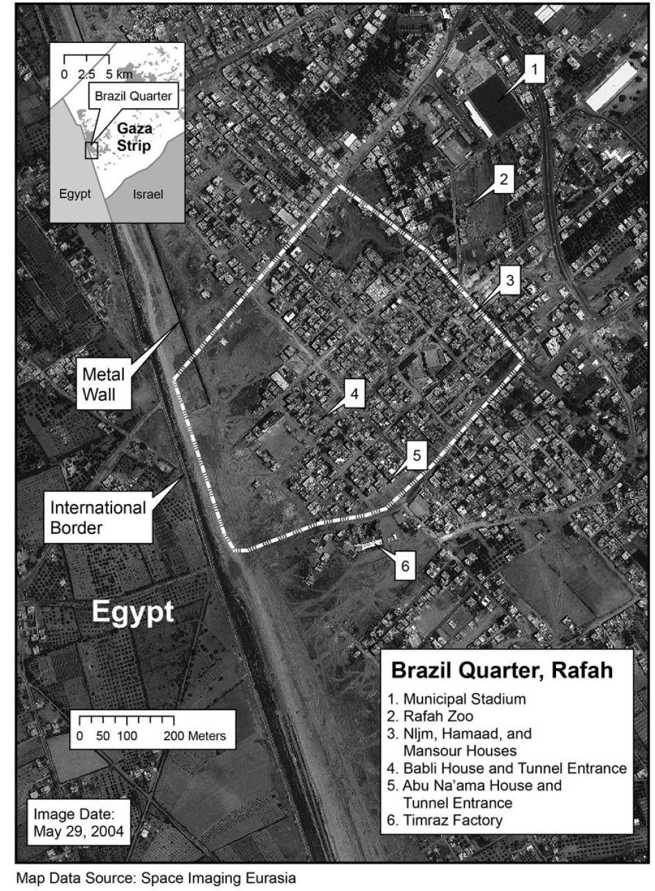
faces the parts of Rafah that used to be closest to the border.Such a structure would have greatly enhanced the security of IDF patrols by allowing armored vehicles to patrol without being seen by Palestinian snipers, while fortified IDF towers in the patrol corridor and built along the wall could monitor and respond to attacks on the wall from Rafah.Other security measures permitted under international law, such as restricting access to areas near the wall or taking control of property[147] along it (i.e. seizing homes and closing them off in a reversible manner), could have supplemented these moves.Instead of attempting any of these measures, the IDF resorted to demolitions en masse, without warning, often in the middle of the night.
Most importantly, the IDF built the wall inside the demolished area, some eighty to ninety meters from the border.Such an expansion doubled the width of the patrol corridor and was not required to safeguard the border, as the previous twenty to forty meter-wide patrol corridor was amply wide enough for multi-lane use by armored vehicles: For example, the IDF's Merkava tank, is 3.72 meters wide, while Caterpillar D9 armored bulldozers, used in demolition operations, are 4.58 meters wide without armor.
A distraught Rafah resident, bottom left, sits in the rubble of his former home, destroyed by the IDF in May. Behind him stands the metal wall, eight meters high and 1.6 kilometers long, that the IDF built eighty to ninety meters north of the border. Intended to enhance the security of Israeli forces on the border, the tempo of house demolitions increased dramatically after its completion in early 2003.
2004 Marc Garlasco/Human Rights Watch
Although the metal wall was built to enhance the security of Israeli forces on the border, the tempo of demolitions increased dramatically after it was completed in early 2003 (see Graph 1).From the beginning of the uprising in September 2000 until the end of November 2002, the IDF demolished a monthly average of 13.9 houses in Rafah. During 2003, this figure tripled to 47.8 homes per month.The increase continued in 2004, with a monthly average of 78 homes demolished during the first seven months of the year.[148]In theory, the destruction of homes would bring some improvement to the security of Israeli forces on the border, although at the cost of destroying hundreds of homes and rendering thousands of civilians homeless.However, because the IDF built the metal wall several dozen meters inside the demolished area, it has effectively created a new "starting point" for justifying further demolitions.As of late May, the last rows of remaining homes in Rafah were between 100 and 200 meters from the wall, or 200 to 300 meters from the border.This trend is difficult to reconcile with the stated need to demolish houses to ensure the safety of Israeli forces on the border.
GRAPH 1: House Demolitions in Rafah by Month, October 2000-June 2004[149]
The Block O neighborhood, a densely populated area consisting mostly of one-story refugee dwellings, has borne the brunt of the destruction.According to the Gaza-based Palestinian Centre for Human Rights (PCHR), which closely monitors and documents house demolitions, the Israeli military destroyed 426 homes in Block O between October 2000 and the end of June 2004.
The western side of O Block (facing the border) is 350 meters in length. In April 2000 the IDF patrol corridor measured an average of thirty-three meters in width, from the border with Egypt to the concrete wall at the edge of Block O.In total the satellite imagery comparison of Block O between April 2000 and May 29, 2004 shows that 60% of this area of Rafah was damaged.Ground-level assessments by Human Rights Watch researchers indicate extensive damage that is not discernible at two-meter resolution.
Starting in 2003, Block J became another major focus of destruction, with at least 225 homes demolished there.Demolitions have also spread to border neighborhoods such as Salam, Block L, and Qishta.
New Realities: Widening the Buffer Zone
The need for a buffer zone empty of Palestinians in Rafah is not a new concept in Israeli strategic doctrine, which has often emphasized the importance of retaining the external boundaries of the OPT in any final peace agreement.While head of the IDF Southern Command in the early years of the occupation, General Ariel Sharon proposed the creation of settlements (which he referred to as "Jewish fingers") to break up the territorial contiguity of Palestinian cities in the Gaza Strip and thus strengthen Israel's control over the area.He also believed that "it was essential to create a Jewish buffer zone between Gaza and the Sinai [then under Israeli control] to cut off the flow of smuggled weapons and looking forward to a future settlement with Egypt to divide the two regions."[150]Although the "disengagement" plan would necessitate an abandonment of the Gaza settlements, the idea of the buffer zone along the border remains and is being gradually implemented.
In more recent years, high-level Israeli officials have spoken publicly of the need to expand the buffer zone by destroying all houses within a certain distance of the border.Increasing the distance between the homes and the border would make attacks on patrols and tunneling more difficult, they say.
Under international law, an Occupying Power may take a wide range of measures to improve its general security, including building fortifications and restricting movements of the civilian population, but destruction must be linked to combat.Border patrol operations by themselves are not by themselves combat operations.Even if fighting in a particular area of the border reaches a level of regularity equivalent to an ongoing state of hostilities, the IDF is permitted to attack only those specific homes that were making an effective contribution to military action and whose destruction would have offered a definite military advantage.In cases of doubt, under international humanitarian law, objects normally dedicated to civilian purposes, such as houses, are presumed not to be military objectives.[151]Destroying homes simply because they are within weapons range of IDF positions is accordingly unlawful.Given the evidence presented that the homes were mostly inhabited, these areas retain their overall civilian character and cannot be lawfully razed wholesale.[152]
In January 2002, the IDF demolished a group of houses in Block O, the largest destruction operation during the uprising until that time.Twenty-one "mostly uninhabited" buildings were torn down and one tunnel was found, said Major-General Doron Almog, head of the IDF Southern Command at the time and responsible for operations in the Gaza Strip.[153]But UNRWA, PCHR, and the Israeli human rights organization B'tselem estimated that approximately sixty houses had been destroyed and they presented evidence that most were inhabited at the time.[154]The international community largely saw the demolitions as retaliation for the killing of four Israeli soldiers the previous day by Hamas at an outpost more than eight kilometers outside of Rafah, at Kerem Shalom near the Gaza Strip.Israeli officials repeatedly insisted that the demolitions had been planned weeks earlier and were unconnected to this attack.[155]
At the time, senior military officers were frank about the need to expand the buffer zone and to destroy houses as a precautionary security measure.According to Major-General Almog, the operation served several purposes:
The direct intentions of this operation were to weaken the fear of the existence of tunnels underneath the Termit post, to create better observation [of?] territories for the forces and to limit the mobility of the terrorists who are trying to approach the road and injure IDF soldiers.The need to expose and to enlarge the IDF's area of activity of operations on the Philadelphia became grater [sic] since the beginning of the current events, there is no doubt about that, the question is concerning the timing.On the same Saturday a tunnel was found which proves operational necessity that exists there all the time.[156]
Almog's predecessor as head of the Southern Command, Major-General Yom-Tov Samiya, was more blunt.Samiya reportedly gave an interview on Israeli radio in which he spoke of demolitions as a "long-term policy."He also advocated acts of collective punishment, which are strictly prohibited under international humanitarian law[157]:
The IDF has to pull down all the houses along a 300-400 meter strip.No matter what the final settlement will be in the future, that will be the border with Egypt. Arafat should be punished and after every attack, two to three rows of houses should be demolished.[158]
After five soldiers were killed in an APC near Block O on May 12, 2004, the idea of widening the buffer zone was again publicly discussed in Israel, from the highest levels of government down.
The day after the incident, Prime Minister Ariel Sharon, Defense Minister Shaul Mofaz[159], and other officials approved a plan to demolish "dozens or perhaps hundreds" of homes to widen the corridor three hundred meters or more.According to one unnamed Israeli official, "It's a measure that we are taking to provide better protection for armored personnel carriers and the soldiers, and to reshape that theatre of war so we will enjoy an advantage and not the Palestinians."[160]In a cabinet meeting on May 16, IDF Chief of Staff Lieutenant-General Moshe Ya'alon reportedly spoke of the need to demolish hundreds of homes, while Mofaz said that Israel would create a "new reality" along the border.[161]
In an unambiguous statement of policy, an IDF briefing document on Rafah tunnels announced, "In order to prevent weapons smuggling, the IDF is widening the Philadelphi route in order to maintain the integrity of the internationally recognized border, to prevent terrorism, and to protect Israelis and Palestinians from terrorism."[162]
As international criticism over IDF actions in Rafah peaked, the formal plan to widen the route was delayed.On May 20, Deputy Prime Minister Ehud Olmert reportedly told U.S. Secretary of State Colin Powell that the plan would not be carried out.[163]Also on May 20, Attorney General Menachem Mazuz asked the IDF to revise the plan, arguing that it would not pass international or domestic legal tests.[164]According to press reports, the IDF has since debated offering compensation to owners of demolished homes under such a plan.[165]The IDF is also reportedly considering inviting Mazuz and Supreme Court Chief Justice Aharon Barak to tour the route to convince them of the need for further destruction.[166]No decisions have been announced on the proposed plan.
IDF commanders on the ground have voiced their desire to wipe away rows of housing to reduce risks faced by their forces."I'd eliminate at least another 200 meters of houses, leaving my soldiers outside anti-tank weapon range," said Colonel Pinhas "Pinky" Zuaretz, in June 2004, while still head of Israeli forces in the southern Gaza Strip.[167]
According to Zuaretz's replacement, Colonel Yehoshua Rynski, the IDF has recommended to the Defense Ministry that the buffer zone be widened to three hundred meters.[168]Rynski appeared to be speaking of demolishing all homes within three hundred meters of the IDF wall i.e., nearly four hundred meters from the border since most of the Palestinian homes within three hundred meters of the border itself have already been destroyed and one of the purposes of the demolitions is to put greater distance between IDF positions and the camp.[169]According to Rynski, the IDF has "grave suspicions"[170] that Palestinian armed groups are smuggling rockets and surface-to-air missiles into Rafah that are far more sophisticated than the homemade rockets currently being used.So far, there is no evidence suggesting that such weapons have reached the Gaza Strip, and the IDF did not claim that this has happened; both Palestinian armed groups and the IDF have told Human Rights Watch that such weapons would have been used already had they arrived.Foreign diplomats with whom Human Rights Watch spoke have expressed skepticism about the likelihood of such weapons entering Rafah through Egypt in the foreseeable future.
In such a densely populated area, widening the buffer zone to this extent would affect hundreds, if not thousands, of Palestinian homes.Based on an analysis of satellite imagery, Human Rights Watch estimates that a buffer zone extending four hundred meters from the border would result in destroying approximately 30 percent of the central camp.This would result in the displacement of tens of thousands of Palestinian civilians, already living in one of the most densely populated areas on earth.
The indiscriminate destruction of entire neighborhoods of Rafah would result in the forced displacement of tens of thousands of people.The IDF's "grave suspicions" of more advanced weapons possibly entering Rafah through Egypt at an indeterminate point in time in undetermined circumstances cannot justify actions that, under international law, must be "absolutely necessary" for combat activities.Moreover, as demonstrated in this report (see Chapter 4), Israeli forces should be able to effectively prevent smuggling through tunnels using less destructive means.
Plans for expanding the buffer zone accelerate in tandem with preparations for "disengagement."The plan explicitly envisions the possibility of further demolitions in Rafah on the basis of vague "security considerations" without making any reference to actual combat.As Article 6 of the plan states:
The State of Israel will continue to maintain a military presence along the border between the Gaza Strip and Egypt (Philadelphi Route).This presence is an essential security requirement. At certain locations, security considerations may require some widening of the area in which the military activity is conducted.[171]
Map 4 : Existing and Proposed Buffer Zones
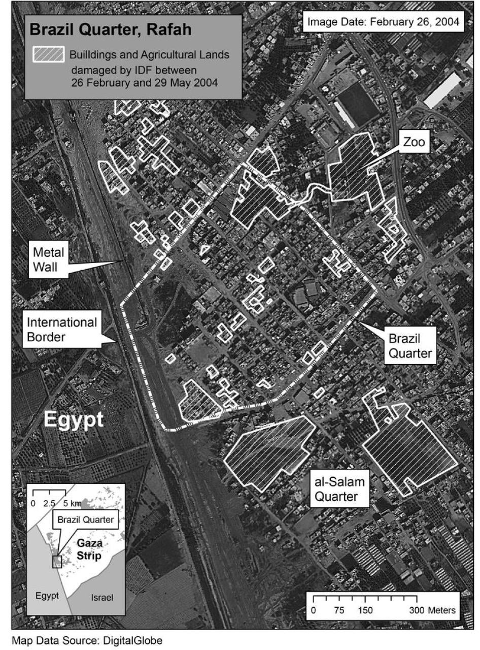
Impact of Destruction
Whether along the border or deeper into the camp, house and property destruction in Rafah has had a severe impact on the community.Most concretely, homelessness places a heavy burden on poor families, who are forced to rent or buy new homes, or in many cases live with relatives.Trauma, tension, and anxiety have risen, as has violence at home and in schools.Malnutrition and physical illnesses are serious concerns for the international agencies that already keep much of the Gaza Strip afloat through programs and aid.
In the aftermath of the May incursions, documented in detail below, UNRWA temporarily housed approximately two thousand five hundred people in three of its schools, with up to fifty people in one room.That number dwindled as families found alternative housing with relatives, rented new homes or occupied empty spaces in town, but UNRWA noticed a "relatively slow movement" out of their schools, indicating a saturation of the housing market.[172]
A Rafah family's sleeping room at a UN school in July, two months after the IDF destroyed 298 homes. Rafah is one of the most densely populated towns in the world, and housing is in short supply. 2004 Fred Abrahams/Human Rights Watch
The demolitions have dramatically reduced available housing in what was already one of the most densely populated areas on earth.Funds are available to rebuild approximately one thousand housing units barely half of what has been destroyed.Construction, however, has been delayed in part because of the lack of available land in the Gaza Strip.In other cases, rebuilt homes remain vacant due to the danger posed by nearby IDF bases.
Fathiya Abdul Rahman Abu Tueor, for example, was one of six families still living in the al-Khansaa elementary school when Human Rights Watch visited on July 15.She explained how she and her family had fled their house in Block O when a tank knocked down a wall on May 12."It was totally destroyed," she said."We lost everything, all our furniture, our books and even our IDs."For one month afterwards, thirty people slept in one room at the school, but by July they were down to ten.[173]
In the same school, Sabreen Faramawi from Block O, who fled on May 12 when her house was hit by IDF shelling, complained how difficult it was to find a new home."We have no plans for the future.There are no empty flats in Rafah.It will cost U.S.$ 140-150 per month she said."And it will not be like our old house, it will be small and without necessities.We are calling out for help but nobody pays attention.We have no water and we have to buy it from the store."[174]
Qifaya Abu Shar and her family was living in the UN's Boys Prep B school two months after IDF forces destroyed their Brazil home on May 19. Five members of the family hid in a back room as a bulldozer destroyed part of their home. "I was amazed the sun rose and we were still alive," she said. 2004 Fred Abrahams/Human Rights Watch
In Boys Prep B school, Qifaya Abu Shar explained how she and her family were awakened abruptly on the night of May 19 when a bulldozer knocked down their neighbor's house in Brazil.Five members of the family hid in a back room as the bulldozer destroyed part of their home."I was amazed the sun rose and we were still alive," she said.They went to the UNRWA school when the army withdrew.At first, six families lived in one room, she said, about fifty people.By July ten people were sleeping in one room.[175]
In addition to those made homeless, some families remained in their homes near the border despite the constant shooting and risk of military incursion.Mahmoud Fathi said that he and his family stayed in their house in Block J, in view of the Philadelphi Route and one of the few houses in the area still intact, because they had no money to live someplace else."No one can live upstairs because a bullet can come at any moment," he told Human Rights Watch."But the ground floor is protected by rubble from houses destroyed in Rainbow.This was one of the most affected areas.Like always, they used the tunnels as an excuse to destroy the neighborhood."[176]
Human Rights Watch also met residents who slept with relatives in cramped homes and spent days in and around their damaged or destroyed homes, where they enjoyed more space and proximity to friends.Naim Abu Jarida, for example, told Human Rights Watch that a bulldozer had destroyed his house just west of the Rafah zoo on May 19.The family had fled temporarily the day before and all their possessions were lost.UNRWA gave the family money to rent a new home but they spent their days at the remains of their old house, a pile of concrete, lounging under a makeshift shelter of aluminum siding.[177]
One man, Jamal Radwan, thirty-seven years-old, had lived in Block O for thirty-three years.His house was partially destroyed on March 17, 2004, but it remained livable for Jamal and seven family members, he told Human Rights Watch.That ended in May 2004, when IDF bulldozers destroyed the rest of his house, leaving only a fractured piece of white.
Jamal Radwan in front of where his house in Block O stood until the IDF destroyed it on May 14. "I still come every day to Rafah because my whole life is in Rafah," he said. Block O used to extend to the edge of the Israeli patrol corridor but successive demolitions since 2000 have wiped away large portions of the neighborhood.
2004 Fred Abrahams/Human Rights Watch
When Human Rights Watch met Radwan, he was sitting by himself on a stoop in Block O near his demolished home.He lived with his brother in a house several kilometers north of Rafah outside of Khan Yunis, he said, but "I still come every day to Rafah because my whole life is in Rafah.I can't live in Khan Yunis.I come here to see the people."
Because he and his family were living with his brother, they were not eligible for a new house from UNRWA, Radwan said, showing a letter from UNRWA to that effect.He used to run a fruit and vegetable shop near Salah al-Din gate, but it was demolished in November 2003, and now work is hard to find."I'm living with my brother but sooner or later I need to rent an apartment," he said."He can't support me forever."[178]
VI. A VIOLENT SEASON: DESTRUCTION IN RAFAH, MAY 2004
In May 2004, while Israeli society debated the merits of Ariel Sharon's proposal to "disengage" from the Gaza Strip and a handful of West Bank settlements, the IDF launched a major military campaign in the Gaza Strip that resulted in widespread destruction unprecedented in the current uprising.
Rafah bore the brunt.During forays into the camp, the IDF razed entire rows of houses along the buffer zone and destroyed extensively deep inside Rafah.Armored Caterpillar D9 bulldozers plowed through houses and shops, indiscriminately ripped up roads, destroyed water and sewage systems, and turned agricultural fields into barren patches of earth.Fifty-nine Palestinians were reportedly killed in Rafah during a series of incursions from May 12-24, including eleven people under age eighteen and eighteen armed men.[179]In total, these incursions left 254 houses destroyed and nearly 3,800 people homeless; another forty-four houses were razed in the Rafah area during the same month in smaller operations.May 2004 witnessed a level of destruction unprecedented in Gaza during the uprising the number of homes destroyed that month was 8.75 times the monthly average for Rafah.[180]
Most of the destruction took place between May 18 and 24 during the major incursions into Tel al-Sultan and Brazil.Instead of attempting to control the heart of the camp as many residents expected, the IDF focused its attack on specific neighborhoods whose wide streets facilitated the movement of their forces and would have deprived Palestinian gunmen of cover to move undetected.Israeli forces converged from multiple directions, quickly overwhelming armed resistance with Apache helicopter gunships and Merkava tanks.Based on interviews with the IDF, two Palestinian armed groups, international aid agencies and residents of Rafah, as well as physical examination of the town, Human Rights Watch found little evidence of a sustained battle or resistance in Rafah during the incursions into Tel al-Sultan and Brazil.Instead, extensive destruction of infrastructure and property occurred mostly in areas already under direct Israeli control.Human Rights Watch's research strongly indicates that the nature and scope of the destruction could not have been justified by absolute military necessity.One of the most egregious examples was in the neighborhood of Tel al-Sultan, where two large agricultural fields were destroyed after the area was effectively secured (see below).
During the May 18-24 incursions, the IDF says it found three[181] tunnel entrances: One was in the vicinity of the Termit outpost in the buffer zone.Another, in the Brazil neighborhood, was an incomplete shaft that Rafah residents say had already been sealed by the PNA weeks earlier (see Chapter 4).The third was in the town of Dahaniya, located four kilometers outside Rafah and not connected to any demolitions.[182]The IDF reportedly killed thirty-two Palestinian civilians, of whom ten were under age eighteen, as well as twelve armed fighters.According to UNRWA statistics, the IDF destroyed 166 houses, leaving 2,085 people homeless.
Rampage in Rafah: An Overview
On May 12, an IDF armored personnel carrier (APC) was destroyed in the Rafah buffer zone near Block O, apparently by a rocket-propelled grenade.The APC was heavily laden for explosives to be used in an antitunneling operation.It is unclear whether the APC was on its way to an incursion into the camp or if it was to be used inside the buffer zone only.The powerful explosion killed five soldiers and showered the area with fragments.The military wing of Islamic Jihad claimed responsibility.
The attack on the APC more than doubled the number of Israeli fatalities in Rafah over the past four years.And it came one day after the death of six soldiers in an APC during an incursion into the GazaCity neighborhood of Zaytoun.The back-to-back incidents with eleven deaths prompted calls for both strong action and accelerating the "disengagement" from the Gaza Strip.
Shortly after the APC was destroyed in Rafah, IDF troops entered the buffer zone to collect the soldiers' remains.Within hours, tanks, Caterpillar D9s, and helicopters moved against Block O on the evening of May 12, firing shells and missiles as residents fled.Rafah residents interviewed by Human Rights Watch saw small groups of armed fighters approaching Block O as they fled.The flight of the civilians under IDF fire, leaving few eyewitnesses, makes a detailed assessment of the nature and extent of hostilities in Block O difficult.The IDF insists that soldiers engaged in the recovery operation came under constant fire from the area.While there were hostilities in Block O, the nature and extent of the destruction suggest that bulldozing was indiscriminate and excessive.The IDF demolished several rows of houses in Block O, including homes that had been separated from the buffer zone by several others.As nearly all of the housing in this area had been composed of one-story houses and were located on level ground, it is unlikely these homes could have been used to fire at the APC or the recovery teams.
On the second day of the incursion, Israeli forces moved into Qishta, a neighborhood next to Rafah, also facing the border, and spent one day methodically bulldozing shops and small houses, while commandeering taller buildings as sniper outposts.Many residents did not expect an incursion there and were still at home, as Qishta has experienced relatively few demolitions.Eyewitnesses insisted that Palestinian fighters were not operating in the area, and Human Rights Watch researchers found no evidence of battle damage on the sides of remaining buildings that did not face the border.The IDF also destroyed homes that were several rows from the buffer zone; some homes were demolished even though their view to the buffer zone was obstructed by taller buildings that are still standing.Two Israeli soldiers were killed in Qishta and two more wounded late in the operation, but they were apparently shot by snipers stationed outside of Qishta.
Map 5: IDF Operations in Rafah May 2004
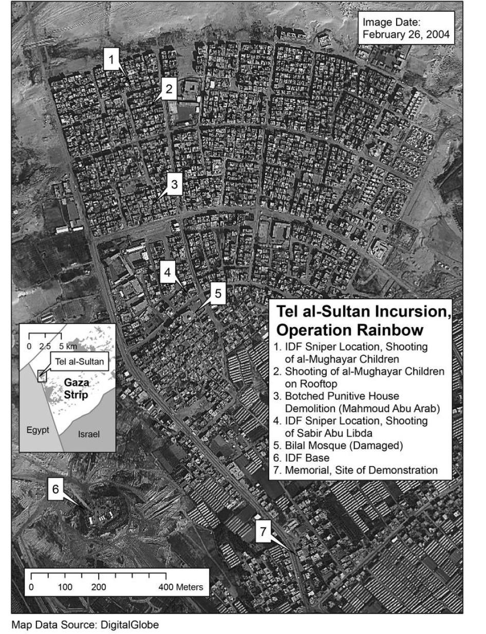
By the time the IDF left Block O and Qishta on the morning of May 15, it had demolished at least eighty-eight houses.[183]During the two-day incursion, fifteen Palestinians, one of whom was under fifteen years old, were killed, mostly by helicopter-launched missiles in other parts of Rafah; according to press reports, six of the dead were armed fighters.[184]
As the IDF tore away the edges of Block O and Qishta, high-level Israeli officials approved plans to widen the buffer zone by demolishing "dozens or perhaps hundreds" of homes (see previous chapter).[185]After an outbreak of international criticism, the government decided not to implement the plan immediately but continued to prepare for a large-scale assault on Rafah.The main stated aim of the operation then became the destruction of smugglers' tunnels.
On May 17, the IDF launched "Operation Rainbow," the first division-level offensive in the Gaza Strip during the current uprising.It primarily targeted two areas: Tel al-Sultan, on the northwest outskirts of Rafah; and the Brazil and Salam neighborhoods, in eastern Rafah, closer to the border.To the surprise of many residents and members of armed organizations interviewed by Human Rights Watch, the IDF did not enter the densely populated center of Rafah, including areas such as Shabura and Yibna, where armed organizations had concentrated fighters and prepared roadside bombs.
Both Tel al-Sultan and Brazil are housing projects built in the 1970s to resettle Palestinian refugees who were displaced, many for the second time, by house demolitions in Rafah.In 1971, the IDF Southern Command, then led by General Ariel Sharon, demolished several hundred houses to widen roads in the center of Rafah to increase the IDF's control in the camps.[186]The widened streets in Rafah became known euphemistically as "Sharon Boulevards."Tel al-Sultan and Brazil were consequently designed by Israeli authorities with these concerns in mind, including wider streets to facilitate vehicular access.[187]According to one architect's analysis of Tel al-Sultan written before the current uprising (and which could be applied to Brazil as well):
... lessons learned from the 'Iron Fist' policy of suppressing Palestinian resistance and the thinning out of the refugee camps have been integrated into the planning of Tel al-Sultan. The street grid of Tel al-Sultan is based on the 'Sharon Streets' of the early 1970s: the wide perimeter road and the single transverse road allow for easy access for military vehicles. From these main roads, there is no single blind alley. All the secondary streets and alleys are oriented towards the primary access roads, allowing for clear lines of [sic] site from the main roads to anywhere in the camp. A military patrol can effectively bring the community under complete control without setting foot in it.[188]
Based on observation by Human Rights Watch researchers, who covered the areas on foot, and on satellite imagery, the average width of the streets in these areas was ten meters, with additional space on either side.A Merkava tank is 3.72 meters wide; a Caterpillar D9 armored bulldozer is 4.58 meters wide without armor.Wide roads also restrict the mobility of fighters by depriving them of adequate cover and complicating the laying of explosive devices.The width of the roads also contradicts a reason given by senior IDF officers for the destruction in the camp, namely that the streets were too narrow for use by armored vehicles.[189]
In Brazil, the IDF bulldozed paths through houses.An IDF officer confirmed to Human Rights Watch that Israeli forces inside Brazil followed a general directive to avoid roads even those wide enough to accommodate armored vehicles as much as possible, irrespective of whether a particular area was believed to be rigged with explosives or not.
According to a list of 290 houses destroyed in Rafah in May 2004 prepared by PCHR, at least ninety percent were one-story dwellings.Unlike in Block O, Brazil is an area where single and multi-story housing is largely mixed; yet there is no reason to presume why one-story buildings would be more likely to conceal tunnel exits or would be more likely to be used by Palestinian attackers.Numerous Rafah residents expressed the belief that one-story structures were demolished simply because they were easier to destroy.
| Box 3
Destruction in Rafah: Shifting Justifications Israeli officials gave different reasons for the assault on Rafah after the death of five soldiers in the Philadelphi corridor on May 12.As the operation continued and international criticism mounted, the justifications for demolition evolved from the broadly strategic to the narrowly tactical, relying on claims that became increasingly difficult to confirm. On May 13, the day after the incident, Prime Minister Ariel Sharon, Defense Minister Shaul Mofaz, and other top officials reportedly approved a plan to widen the Philadelphicorridor by destroying "dozens or perhaps hundreds" of homes.[190]At the same time, the IDF was in the midst of demolishing homes in Block O, effectively contributing to such an outcome. When the plan was reported in the Israeli media the next day, international criticism began to mount.U.N. Secretary-General Kofi Annan "strongly condemn[ed]" the widespread destruction of homes in the Gaza Strip.[191]Speaking for the E.U. Presidency, Irish Foreign Minister Brian Cowen called upon Israel to "immediately" halt demolitions in Rafah.[192]Two days later, during a brief respite in demolitions, U.S. Secretary of State Colin Powell voiced opposition to the "wholesale bulldozing of houses" in Rafah: "We know Israel has a right for self-defense, but the kind of actions that they're taking in Rafah with the destruction of Palestinian homes, we oppose."[193] On May 17, the IDF launched a major operation aimed at Rafah ("Operation Rainbow") but the goal of widening the Philadelphi corridor was replaced in public statements with acombination of objectives: Finding and destroying smuggling tunnels, targeting "terrorists," and securing the Philadelphi road.The last of these objectives was still vague enough to include widening of the buffer zone through house demolitions.[194] As the operation started, Israeli officials added another, more urgent reason.On May 18, IDF Chief of Staff Lieutenant-General Moshe "Bogey" Ya'alon told the Knesset Foreign Affairs and Defense Committee of arms shipments in the Sinai from Iran waiting to be smuggled through the tunnels into Gaza.[195]Subsequent leaks to Israeli media mentioned anti-aircraft missiles and long-range rockets waiting to get in.According to a press report based on one unnamed IDF source, the arms were brought into the Sinai by, among other means, tunnels underneath the Suez canal.[196]Israeli Justice Minister Yosef "Tommy" Lapid said on May 20 that the Rafah operation was necessary to protect Israeli civilian airliners from anti-aircraft missiles that smugglers were attempting to bring into Rafah: "If this happens, God forbid, and airplanes are shot down, people will ask us why we didn't act to stop it."[197] Israeli officials never explained what Egyptian authorities were doing about the alleged arms or what ultimately became of them, citing security concerns.They have made no claims to have captured such weapons.In conversations with Human Rights Watch, multiple foreign diplomats in Tel Aviv who were briefed about the alleged cache by the IDF treated the claim with skepticism.A high-ranking Egyptian Ministry of Interior official interviewed by Human Rights Watch denied the existence of the shipment.[198]An official with the Multinational Force and Observers (MFO) that monitors the Egypt-Israel border also had no knowledge of the alleged arms and said that neither state had asked the MFO to conduct a search.[199]When asked for information about what became of the shipment, an IDF spokeswoman declined to provide further details to Human Rights Watch.[200]Human Rights Watch did not find any further references to the shipment in public statements by Israeli officials While few commentators in Israel questioned the need to combat smuggling tunnels, many saw the assault on Rafah as excessive, and mainly motivated by an IDF desire to appearstrong in the event of "disengagement."One veteran military analyst wrote: The decision to undertake the operation 'came from the gut, not the head,' as army idiom puts it; and its goal was to show the Palestinians what will happen in the future if they continue to resort to violence after Israel pulls out of the Gaza Strip. This was an operation undertaken by an angry army.The blowing up of two IDF armored personnel carriers in the Gaza Strip infuriated the IDF General Staff.[201] Damage to Israel's international image concerned even those who supported the operation in principle.As one commentator said: the operation made us forget to some extent the feeling of failure and helplessness over the Palestinian RPG rocket attacks, and returned the initiative to the IDF. [but] in the world which has already completely forgotten the attacks on the armored personnel carriers the operation resulted in heavy public relations damage.And in this case, the price was heavy because in addition to the fact that it required thousands of soldiers, the terrible pictures of the demolished houses in Rafah and their pitiful owners among the ruins touched many hearts in Israel as well, and made it clear to the IDF that its scope of legitimacy for drastic actions is limited.[202] An editorial in the daily newspaper Yediot Ahronoth proclaimed: "In delicate language, this is 'searing the consciousness' in another phrase coined by the IDF In slightly less polite language, this is revenge, pure and simple."[203] |
After sealing Rafah from the rest of the Gaza Strip, Israeli forces seized control of Tel al-Sultan on May 18 and imposed a twenty-four hour curfew.The IDF reportedly killed twenty Palestinians, fifteen of whom were civilians, and destroyed ten houses in Tel al-Sultan.Israeli D9 bulldozers extensively tore up roads, causing severe damage to sewage and water networks.Elsewhere in Rafah, IDF helicopters killed six Palestinians, including three armed men who were in Block P, adjacent to Block O and away from Tel al-Sultan.All of the fighters were killed during the initial phase of the incursion.
On May 19, a group of several hundred Palestinians marched towards Tel al-Sultan from the center of Rafah, demonstrating against the incursion there.Israeli tanks and helicopters opened fire on the crowd, killing nine people, includingthree people under age eighteen.The IDF did not claim that its forces had come under fire, but did allege that there were gunmen in the crowd; Palestinian and foreign eyewitnesses disputed this (see Box 4 below).
Despite international condemnation of the killings at the protest, the Israeli incursions accelerated.On the night of May 19, the IDF invaded Brazil from the north and east, cutting it off from the center of Rafah.Israeli forces demolished extensively, often bulldozing paths through houses in order to avoid roads.They also wiped away blocks of housing near the border, both in Brazil and Salam, ostensibly in the search for tunnels.Many residents had only moments to leave their homes, or were inside their homes as demolitions began.According to UNRWA, the IDF destroyed 154 houses in these two neighborhoods, leaving over 1,900 people homeless.Four Palestinian civilians were reportedly killed, including a three-year-old girl shot near her home and a three-year-old boy who died of shock from a house demolition.Four armed fighters were also killed by helicopter-launched missiles in the early hours of the incursion.Another Palestinian civilian was reportedly shot near his house elsewhere in Rafah.The IDF claimed to have found three smuggling tunnels, but later clarified that one was an incomplete shaft and another was outside of Rafah.
On the morning of May 21, the IDF pulled out of the centers of Tel al-Sultan and Brazil but maintained a tight cordon.Demolitions continued in Brazil and Salam closer to the border while IDF D9s razed two large swathes of greenhouses outside Tel al-Sultan over one kilometer from the border.The operation came to an end on May 24, as Israeli forces left the area.
In an overview briefing given to journalists at the close of the operation, the IDF made no specific references to armed resistance from Palestinians, instead generally claiming that "the terrorists where shooting from inside populated houses" and that forty "armed terrorists" had been killed a figure which would have to assume that every adult male killed was a combatant, as well as at least four of the child fatalities.[204]The IDF later told Human Rights Watch that "IDF forces faced attacks from the terrorist activists in the form of automatic weapons' fire from occupied and abandoned buildings and streets, grenade attacks, anti-tank fire and high-explosive devices," but was vague as to whether this description referred to the May 18-24 operations in Tel al-Sultan and Brazil only or included the May 12-15 incursion into Block O and Qishta as well.[205]
Based on extensive interviews with Rafah camp residents, members of armed organizations, and a review of IDF statements and media reporting, Human Rights Watch finds that armed resistance in Tel al-Sultan and Brazil was limited at best.The IDF operated in areas where the urban layout presented the fewest risks and where they were least expected by Palestinians, including armed groups.In the initial hours of the incursion, armed gunmen in these areas were quickly overwhelmed by helicopter gunships, tanks, and snipers as the IDF took control of targeted neighborhoods.The IDF suffered no fatalities or injuries during the six days and did not respond to Human Rights Watch's verbal and written requests for figures on vehicles damaged or destroyed, incidents of armed confrontation, or IEDs encountered.[206]
By limiting the scope of the operation to the newer housing projects with their wider streets, the IDF largely circumvented most of the Palestinian fighters and was able to keep them at bay by controlling key access points.This contrasts sharply with the April 2002 assault on Jenin refugee camp, in which the IDF attempted to fight its way through the densely populated heart of the camp, resulting in the death of fifty-two Palestinians, including twenty-seven confirmed civilians, and thirteen IDF soldiers and the leveling of the center of the camp.
Rafah residents and members of armed organizations consistently told Human Rights Watch that both the neighborhoods and routes chosen by the IDF were a surprise, and probably calculated to minimize confrontation with armed groups.As one fighter from Islamic Jihad said:
Areas like Brazil and Tel al-Sultan are easy for the army to invade.We're waiting for them to come to the center of the town in Yibna. The places they invaded, it was very difficult for us to resist there.Tel al-Sultan was closed off, so what could we do?Brazil, too, we didn't expect.And Brazil was sealed off so, in fact, the resistance had no successes [there].[207]
A member of the Popular Resistance Committees similarly told Human Rights Watch:
Tel al-Sultan was easy [for the Israeli army].It is surrounded by settlements, it has wide streets, and it was easy to invade and control.In Tel al-Sultan it was difficult for the resistance to do its work well. [In Brazil] Some roads they chose were not anticipated.The roads they took were not a threat to us.This didn't affect us.[208]
Consistent with these claims, a thorough search of media reporting shows only two communiqus issued by Palestinian groups claiming responsibility for attacks on IDF forces in Rafah during the May 18-24 incursions: one for an explosive charge set off against an APC in Tel al-Sultan and another attack on a D9 in Jnayna neighborhood on May 20.[209]
The scarcity of evidence indicating combat in the public statements of the IDF and Palestinian armed groups contrasts sharply with the October 2003 IDF incursions into Rafah that left 198 homes demolished, also with no IDF fatalities.Statements issued by the military wings of Hamas and Islamic Jihad at that time, although possibly exaggerated, claimed credit for six explosive charges against tanks and D9s, two shooting attacks on IDF troops, and an RPG strike on an Israeli APC.[210]Similarly, an IDF press release on the October incursions reported that "During the operation, an exchange of fire erupted, in which two soldiers were lightly wounded.Terrorists detonated dozens of explosives, hurled dozens of grenades, fired anti-tank missiles, and fired numerous times at IDF forces from buildings in the area.IDF forces returned fire."[211]
Rafah Incursions by Neighborhood, May 12-24
Block O & Qishta (evening May 12-morning May 15)
Block O is one of the most densely populated areas of Rafah refugee camp, consisting mostly of overcrowded one-story concrete homes with asbestos roofs, separated by very narrow alleys.Block O used to extend to within several meters of the edge of the Israeli patrol corridor but successive demolitions since 2000 have wiped away large portions of the neighborhood.
In little more than forty-eight hours from the evening of May 12 to the early morning of May 15, the IDF demolished approximately one hundred houses in the two areas.In Block O, entire chunks of refugee dwellings were razed, widening the buffer zone.In Qishta, the IDF razed one-story homes but left many of the taller buildings standing, leading many to believe that smaller homes were targeted because they were easier to bulldoze and not because of absolute military necessity.The IDF also reportedly killed nine Palestinian civilians and six fighters in various parts of Rafah, many of them killed by missiles launched from helicopter gunships at Block O as well as other areas.
Human Rights Watch spoke to a number of residents who heard the explosion of the Israeli APC in Block O in the late afternoon on May 12.The shock of the explosion soon gave way to fear of revenge.Awad Seidam, who was still living with his family in the classroom of a local elementary school two months after the demolition, recalled the incident vividly:
We were sitting in our houses.There was no shooting from either side before the explosion.We are used to hearing tanks and APCs coming but everything was quiet this time. A piece of the vehicle fell into my house, coming through the window. In minutes, word had spread that an APC had been destroyed.At that moment everyone knew revenge was coming.I thought to myself, "They kill us without a reason anyway, so imagine how it will be this time."[212]
Israeli troops entered the buffer zone shortly after the explosion to recover body parts of the dead soldiers.Having experienced multiple incursions, many Block O residents living near the buffer zone left immediately, leaving few eyewitnesses to the events that followed.Those who lived in houses slightly further from the buffer zone stayed until the IDF began an assault on the area shortly after nightfall with tanks and helicopter gunships.
Sabreen Faramawi, whose home was separated from the demolished area by three rows of houses at the time, had several relatives who were injured by shrapnel from the approaching tanks and helicopters.
The shell from a tank hit one door [of our house just after we left].I took nothing with me, not ID cards, not money, food, or anything. We went back right after the withdrawal.The house was completely destroyed. I was shocked when I saw it.[213]
While local residents saw small groups of armed Palestinian fighters, usually with fewer than half a dozen men each, gathering in or near Block O, the extent to which these fighters attempted to engage Israeli forces is unclear.Human Rights Watch spoke to two residents who, while fleeing the incursion, saw fighters gathering in small groups in Block O, though they did not see them fighting.Even if there had been an organized Palestinian resistance, it is unrealistic to believe that gunmen were shooting from all or even most of the approximately seventy houses destroyed in Block O, especially those located several rows away from the edge of the destroyed area
By the second day of the operation, May 14, Israeli forces began demolishing houses in the Qishta neighborhood.Located next to Block O to the east and also facing the border, Qishta is named for the extended clan that owns much of the area, and was composed of one-story houses with asbestos roofs and multistory dwellings.The Qishta family is originally from Rafah, and consequently there are few refugees in the neighborhood.The area had also experienced relatively few demolitions up until that point, and many residents remained in their homes during the incursion.
At approximately on May 14, a group of Israeli soldiers seized control of a four-story building in Qishta.Hamdia Qishta, her husband, and daughter were home at the time; her sons, who live on the other floors, were abroad, leaving the other apartments in the family-owned building empty:
First [the soldiers] broke the door down and then let dogs in without soldiers.I saw dogs walking around.They went out and came back again. Then the soldiers came.There were more than ten of them.They asked "Who's around?""Just us three," we said.They told us, "Okay, sit here."I lost track of time.I was afraid. They asked my husband to check the other rooms.But he's sick, so I went to the soldiers instead.I went up to the other floors and checked for them.I showed them there was nothing and they said okay.
After finishing the search, the soldiers confined Ms. Qishta, her husband, and daughter to one room on the third floor and started knocking holes in the walls on the fourth floor for use by snipers.[214]
At dawn, Dr. Ihsan Qishta was on the roof of his home watching his brother-in-law Ashraf, aged thirty-seven, move furniture out of his house across the street, which had been partially demolished hours before.Tanks had begun moving out of the area, and rumors were spreading that the incursion was over.The interruption was only temporary, however, and residents soon realized that snipers had set up positions in Hamdia Qishta's home nearby.As Ihsan Qishta explained:
I saw a soldier's arm and a sniper rifle [through an opening in the building].The rifle fired three bullets, with fifteen seconds between each shot.The bullet was not normal.The whole top of [Ashraf's] head was taken off. He was hit twice in the heart, once in the head.I was yelling across the alley at my brother and they shot at me as well.[215]
Within hours, the remainder of Ashraf Qishta's house was bulldozed.His body could not be evacuated until the IDF left the area twenty-four hours later.
Bulldozing continued in Qishta through May 14.Nadia Sha'er saw five armored bulldozers and more than ten tanks in the area, destroying the homes of her neighbors as well as shops.The Caterpillar D9s came to her house in the late afternoon, while she, her mother-in-law, and daughter were inside.She told Human Rights Watch:
[The bulldozer] smashed through the wall of the sitting room.We were in another room at the time.We made a white flag and left immediately through the door. We were standing in the alley and watched two bulldozers destroy the house.It took just a few minutes.There was no warning, no announcement.When I yelled at the bulldozers [to stop], the tanks pointed their cannons towards me. I lived there for over forty years.All of our furniture was inside: the tables, the TV, the chairs, the furniture, the clothes.[216]
Ms. Sha'er escaped to a three-story building next door, shared by her sons and their families.The IDF did not try to demolish it: "It was easier for them to destroy one-story houses," she said."They hit the corners of high buildings [with bulldozers].They destroyed some high buildings but mostly short ones."When Human Rights Watch researchers visited the area, they noticed that several of the multi-story houses had parts of their supporting columns knocked away, which residents said had come from the May incursion.In between the multi-story buildings were expanses of sand where the one-story houses once stood.
Also that afternoon, Palestinian militants killed an IDF soldier in the same apartment building from which Ashraf Qishta was shot.Another IDF soldier was killed in the attempt to evacuate his wounded comrade.Hamdia Qishta, who had been confined with her family to the third-floor apartment since the early morning, witnessed the shooting of one of the soldiers as he stood guard in her sitting room:
I heard one of the soldiers cry out.I went to him in the main hall to see what happened.I didn't see any blood.The other [soldiers] were lying on the ground in fear.I tried to wake him up but he didn't answer.I took off his helmet and flak jacket and found a wound under his left armpit.It was very small.
The other soldier was talking on his radio.Two soldiers eventually came with a stretcher.They crawled along the floor towards their comrade.They were afraid to enter the hall.I asked them to give me the stretcher and I put it under the wounded one and asked for their help [to carry him].I and another soldier carried him.He was bleeding through the wound.He was so young, what do you expect me to do? They carried him down the stairs, and two others stayed with me.I heard people falling in the stairwell.I heard later that another soldier was hit but I didn't see it.All the soldiers soon left.The whole incident took maybe half an hour.They were all very scared.[217]
A Human Rights Watch researcher examined the sitting room in which Ms. Qishta said the soldier had been shot.The room had a large picture window at least 2.5 meters wide facing west that would have been clearly visible from any of several three- or four-story buildings deep in Block O or other neighborhoods.
The IDF gave a different version of what happened in the building: "When an elderly woman asked permission to bring food into the building, [Staff-Sergeant Rotem] Adam escorted her to the entrance and was shot and mortally wounded by a sniper when he opened the door."One of his comrades was shot and killed in the evacuation attempt and two others wounded.[218]
Around on May 14, the Israeli Supreme Court issued a temporary injunction against the demolition of a group of houses in Block O whose owners were represented by Gaza-based human rights organizations, pending a hearing scheduled for May 16.The injunction allowed demolitions to go ahead, however, in the event of immediate military necessity, a risk to soldiers, or a hindrance to a military operation.Around on May 15, the IDF left Block O and Qishta, having demolished eighty-eight homes, as well as twenty-three shops, a mosque, and a bank.[219]The next day, the Court declined to hear the petition after the IDF said that it had no intention of demolishing the homes.
Tel al-Sultan (May 18-May 24)
Tel al-Sultan is a newer neighborhood, a few kilometers west of Rafah's center.More than one kilometer from the Egyptian border and abutting the Gush Katif settlement bloc, it is now home to approximately twenty-five thousand people.The IDF's stated emphasis on tunnel-hunting made the choice of Tel al-Sultan, approximately one kilometer from the border and where no tunnels have been known to have been found, a surprising choice to residents.
Palestinian armed groups said they had lookouts in the neighborhood during the incursion but few fighters.Hostilities had been rare in the area because of its distance from the border, and they did not expect the IDF to invade there.Israeli forces had never entered the neighborhood en masse until May.
During the operation, IDF forces destroyed ten homes and damaged 156 others, affecting 1,826 people, according to UNRWA.One of the houses was apparently bulldozed in a botched punitive demolition.D9 bulldozers and tanks destroyed 75.8% of the roads and caused extensive damage to water and sewage pipes in the area, cutting off water for six days.[220]According to the RafahMunicipality, seventeen of thirty kilometers of water pipes were destroyed and fifteen of twenty kilometers of sewage pipes were destroyed.The cost to repair the systems, the municipality said, was U.S.$ 713,900.[221]Two large agricultural areas with greenhouses were completely razed-in total 298 donums of land (29.8 hectares).[222]
Map 6: Tel al-Sultan 2004
|
IDF soldiers in the Tel al-Sultan neighborhood shot and killed Sabir Abu Libdeh, aged 13, and wounded his two brothers on May 19 when they violated a curfew to get water. Caterpillar D9 bulldozers had severed water pipes in the area. 2004 Fred Abrahams/Human Rights Watch |
IDF forces also reportedly killed fifteen Palestinian civilians in the neighborhood, either by helicopter gunship or gunfire, including three children under age eighteen.Asma and Ahmed al-Mughayer, aged fourteen and ten, respectively, were shot while feeding pigeons on their roof; Sabir Abu Liba, aged thirteen, was killed as he tried to get water.[223]The IDF also reportedly killed five combatants.Human Rights Watch also documented one case of the army forcing a civilian to build sandbags.Most dramatically, on May 19 an IDF tank and helicopter opened fire on a demonstration to protest the destruction in Tel al-Sultan, killing nine and wounding forty-three.) The incursion into Tel al-Sultan began in the early morning of May 18 when IDF soldiers entered the neighborhood backed by armored vehicles, tanks, and helicopters.Around a helicopter gunship fired a missile near the Bilal Ibn Rabah Mosque, wounding two Hamas activists, seventeen-year-old Hany Muhammad Qufeh and twenty-four-year-old Tariq Ahmed Sheikh al Eid. |
Accounts of the incident vary slightly.According to local human rights groups and media accounts, Palestinians on their way to morning prayers went to Qufeh's aid when a second missile struck.[224]Qufeh was killed, as were five others: Tariq Ahmed Sheikh al-Eid, Ibrahim and Ismail al-Bal'awi (son and father, respectively), and Muhammed and Ahmed al-Sha'er (brothers).Two more missiles landed in the area, damaging the mosque.A fire destroyed the top-floor library, which held the largest collection of religious texts in the Gaza Strip.The interior of the library was being repaired when Human Rights Watch visited the site on July 15, but black streaks out the windows from the fire were still clear.
According to the IDF, soldiers spotted several armed Palestinians planting explosives near the mosque, and ordered the gunship attack.[225]Abu Husayn from Islamic Jihad confirmed that Palestinian fighters had planted a mine near the mosque, perhaps the work of Qufeh.Hamas also issued a statement saying that two of its fighters had died: Hany Qufeh and Tariq al-Eid, but it remains unclear if the four other individuals were involved.[226]
Around the same time, three armed activists were reportedly killed in Badr Camp at the edge of Tel al-Sultan.[227]According to Abu Husayn from Islamic Jihad, a Palestinian gunman killed two Israeli soldiers in the Badr Camp section of the neighborhood, but the IDF did not acknowledge these deaths and they could not be confirmed.Residents in the area had heard the story but they were unsure if it was true.
By morning, the IDF had surrounded and sealed Tel al-Sultan with tanks and APCs, forbidding anyone to enter or leave.Inside, bulldozers tore up streets, ostensibly to reveal mines or to impede bomb-laden cars.A trench was dug on the main east-west street linking Tel al-Sultan to Rafah, known as Beach Road (though access to the sea is blocked by Israeli settlements).Soldiers occupied multi-story dwellings, placing snipers on the top floors or roofs with commanding views.
Abdul Sattar Abu Ghali, who had his three-story home occupied in the early morning of May 18, told Human Rights Watch how IDF soldiers destroyed the outside wall of his house with a tank, held his family in one room and forced his twenty-seven-year-old son Wa'el to prepare sandbags for a sniper's nest on the roof.Such destruction of outside walls was common in Rafah because it allowed soldiers to enter a building without exposure in the streets.Forcing a civilian to perform a task that directly supports military activity is a violation of humanitarian law.Mr. Abu Ghali told Human Rights Watch:
Suddenly we heard the sound of the wall crashing in.Then a tank came in backwards into the front room and the soldiers jumped in.They opened the inside door and went straight to the top floor, the third floor.They took my son to the second floor and me too.All of us were on the second floor, about twenty-one people.They also brought another man, Ayman Kurazoon, whom they had taken from his house with his hands tied behind his back.
They took my son to the third floor and they spent a lot of time up there and we got worried.I saw one of the soldiers, a lieutenant, and I asked him where my son was.He said "he'll be right back."When my son finally came down I asked what he had done.He said the soldiers had made him break up the floor, take sand and put it in bags, which were used for protection.[228]
Human Rights Watch saw the spot on the third floor where Abu Ghali said his son had been forced to dig for sand beneath the tiles.The spot on the roof where Abu Ghali said the snipers had been commanded a strategic view over a square and playground in front of the Association of General Services-Canada Camp.According to local residents, IDF troops were also positioned in another house on the opposite corner of the square.Human Rights Watch also saw the destroyed front wall of Abu Ghali's house, where the tank had backed in.
IDF soldiers in the Tel al-Sultan neighborhood forced Wa'el Abu Ghali to make sandbags for their protection on the top floor of his home, which they occupied on May 18. His father, Abdul Sattar Abu Ghali, inspects the spot. 2004 Fred Abrahams/Human Rights Watch
Also on the morning of May 18, IDF armored bulldozers destroyed a one-story house belonging to the Mehsin family in order to reach a three-story house owned by Sameer Barud without requiring soldiers to walk in the open.The Barud house has views over the square to the north of the Bilal Mosque.Approximately thirty family members were huddled on the first floor of Barud's building, where they thought it was safer, when the soldiers arrived, breaking down the back door.One of the men present at the time, who did not want to give his name, explained to Human Rights Watch how his family members were held in one room for four days:
They blew open our door and we were all in one room.They searched all of us and the rooms and put us in one room on the second floor.They only let us go to the bathroom with a guard. We were there for four days, just sitting.[229]
Human Rights Watch saw the small room on the second floor in which the family - six men, five women and nineteen children - was held.Behind the house, to the west, were the mangled remains of the Mehsin family house that the IDF had destroyed to avoid approaching Sameer Barud's building from the front.The family was not aware what the IDF was doing in their house for four days, but they learned later that snipers had been positioned on their roof, with a view over the mosque and the open space to its north.According to one media report, soldiers used Sameer Barud as a human shield, forcing him to go downstairs to check for Palestinian militants.[230]When the soldiers left the house after four days, the family discovered broken windows, doors and furniture.
The IDF destroyed the Mehsin family home, rubble in foreground, to clear a path to the three-story building owned by Sameer Barud. They stayed for four days, holding thirty family members in one room. 2004 Fred Abrahams/Human Rights Watch
With Tel al-Sultan secured, the IDF declared a twenty-four hour curfew and began house-to-house searches.IDF soldiers on loudspeakers ordered men over the age of sixteen to gather at a school.Policemen from the PNA were told to come into the street with their weapons above their heads for reasons that are unclear.
| Box 4
The Demonstration in Tel al-Sultan: Nine Killed and Forty-Three Wounded On March 19, several thousand demonstrators gathered in Rafah near the al-Awda Mosque to protest the IDF's siege of Tel al-Sultan.Around 2:00 p.m. they set out along the main street toward the neighborhood demanding to enter Tel al-Sultan.Approximately 500 meters from the entrance to the neighborhood, an Israeli tank and helicopter opened fire, killing nine Palestinians, including three people under age eighteen. Fifty others were wounded.The IDF alleged there were gunmen in the crowd, although it did not claim to have come under fire.At first, "four to five" of the victims were "armed terrorists," the government said.[231]The IDF later reduced the number to one.[232]After further questioning by Human Rights Watch, an IDF spokesman said that one of those killed, Alaa' Musalam al-Sheikh 'Eid, was listed in IDF records as a "Hamas activist" but he did not reiterate the claim that 'Eid had been armed at the time.[233]Eyewitnesses and Palestinian human rights groups said all the victims were civilians. According to a five minute, fifty-three second video provided by the Palestinian Centre for Human Rights and viewed by Human Rights Watch, a crowd of men and boys was marching down the street shouting "Allahu Akhbar!" (God is Great!)In the crowd, no weapons can be seen.A helicopter is seen overhead shooting flares; such flares, however, are designed to divert heat-seeking missiles rather than to deter protesters and were likely not to have been noticed by many people in the crowd.Suddenly, there is gunfire and people head for cover.A few seconds later, with an edit in the video, there is a large boom from a tank shell.Men are seen carrying off bloody bodies, some of them children.One minute and fifty seconds of uncut video later, there is a second boom.Ambulances arrive shortly thereafter to remove the wounded. The IDF said a helicopter gunship launched a missile at a nearby open area to deter the protesters, which included armed men, and tanks subsequently fired at an abandoned structure near the crowd.The IDF also claimed that it used flares to warn the protestors against proceeding toward Tel al-Sultan.[234]In contrast, eyewitnesses told Human Rights Watch that the killings were not preceded by any warning fire, and that the shelling continued as protestors sought to evacuate the wounded.Even if warning shots had been fired, the use of a helicopter missile and four tank shells without pause in a populated area constituted an excessive and unnecessary use of force. A Dutch photographer present at the demonstration said there were two armed Palestinians in the crowd but they left as the protest approached Israeli troops.He told the al-MezanCenter for Human Rights: I heard and saw no firing at the Israelis from within the demonstration.The first explosion I heard was huge, and it targeted the front of the demonstration.There were numerous casualties.I heard flares of gunfire from Israeli troops as the mass of civilians continued to march.The Israelis fired no warning missiles near the demonstration before this.Then I heard several explosions and saw people running everywhere.I saw what looked to be about fifty casualties; many of them children.[235] IDF Chief of Staff Lt. Gen. Moshe Ya'alon admitted an error, but claimed that armed men were using civilians as a human shield."Unfortunately, a mistake was made this week when gunfire was directed for deterrence purposes against a demonstration and this incident ended with Palestinian fatalities and wounded," he told Israeli Television."We certainly regret this incident, but we did not create this situation. This is a situation with which we have to deal. It is not us who turned civilians into human shields for the terrorists; it is not us who are sending civilians against our soldiers with armed men hiding behind them."[236] When asked why the demonstrators were fired upon, Col. Pinhas Zuaretz, the Israeli commander for the Southern Gaza Strip did not claim that the troops were fired upon or threatened by gunmen.Instead, he told a journalist: "there is no way on earth that you can allow [protesters] to climb on a tank.Photographs of Palestinians climbing on an Israeli tank will be seen all over the world." Zuaretz also claimed that his troops had attempted to deter the protesters using various means."They asked them nicely to stop through the DCO [Israeli-Palestinian DistrictCoordinating Office].It had no effect.A reconnaissance helicopter came in.No effect.They fired shots.No effect.Then the helicopter fired at an open field.Nothing.The commander fired his machine gun.Nothing.The procession stopped for a moment and then continued.The tank commander did not see the demonstrators, but he identified an empty building that he believed was far away from them and fired. One shell four shells." The journalist asked why it was necessary to fire four shells, especially when the tank could not see the demonstrators."I still say that he did not intend to hurt anyone," Col. Zuaretz replied."As far as he was concerned, he did everything he could to avoid causing harm.Still, I must say that had I been in his place, I would have waited after the first shell.After it happened, I told him myself that he should have waited and determined what happened after firing each shell, especially considering that his view of the demonstration was blocked."[237] After international and domestic condemnation, the IDF conducted an internal investigation, which found no wrong-doing by the soldiers involved or their commander. The details of the investigation were not made public. Even in a context of belligerent occupation, the control of crowds and demonstrations falls squarely under the purview of law and order activities governed by international human rights law.The shelling of the demonstration contravenes important principles of human rights law about the use of force and the dispersal of assemblies, irrespective of whether they are lawful.The U.N. Basic Principles on the Use of Force and Firearms by Law Enforcement Officials, which applies to militaries when they police demonstrations, sets out those essential principles.The Principles require that security forces, in carrying out their duty, shall as far as possible apply non-violent means before resorting to the use of force. Whenever the lawful use of force is unavoidable, law enforcement officials must use restraint and restrict such force to the minimum extent necessary.The legitimate objective should be achieved with minimal damage and injury, and with respect for the preservation of human life.Lethal firearms can intentionally be used only when strictly unavoidable in order life.[238] |
Over the next two days, May 18 and 19, the IDF killed fifteen Palestinian civilians according to both the Palestinian Centre for Human Rights and the al-MezanCenter for Human Rights.
The local hospital and ambulance drivers reported IDF restrictions on the movement of medical staff.Due to the siege on Rafah and the minimum capacity of the local AbuYousefal-NajjarHospital, bodies were stored for five days in shops and a vegetable refrigerator.
In one case investigated by Human Rights Watch, three brothers from the Abu Libda family were shot by snipers on May 19 while trying to get water, and one of them was killed.According to family members, the water in Tel al-Sultan was cut off from the beginning of the incursion, and the family's water tank on the roof had been damaged by gunfire or shrapnel.To get water, Ayub, aged twenty-five, Yusuf, aged sixteen, and Sabir, aged thirteen, went with bottles to another brother's house a few meters away, despite the curfew.They were shot when they stepped out the door.A fifth brother, Ibrahim Abu Libda, told Human Rights Watch what he saw:
Sabir was the first one.They were on the street next to our house and the first bullet hit Sabir in the heart.Yusuf was second and he got three bullets: in the abdomen, right arm and back.Third was Ayub.He was hit in the right arm. I was with them but I entered the house first.I got in and the shooting started.I first heard the shooting and then Sabir screaming.He ran inside the house and died there.Ayub ran inside too but Yusuf fell in the street.He was near the door and I pulled him in.[239]
Human Rights Watch inspected the site of the shooting, a few meters from the Abu Libda's front door, northeast of the Bilal Mosque.To the west, across the square, in clear view, was the three-story house of Sameer Barud (see above) that the IDF had occupied the day before the shooting.The snipers on the roof would have had a clear shot down the alley to the Abu Libda house.An Israeli army spokesman told the Washington Post that the IDF was "likely responsible" for the shooting.[240]According to media reports and human rights groups, IDF tanks delayed the ambulance holding the three brothers, and Sabir died before reaching the hospital.In apparent recognition of fault, the wounded Yusuf Abu Libda was taken for treatment to a hospital in Jerusalem.
Over the next few days, the most extensive property destruction was at two large agricultural areas full of greenhouses, both more than one kilometer from the border and not near any settlements.According to Mezan, the fields were razed starting on May 22, after the IDF pulled out of the center of Tel al-Sultan and continued through May 23.[241]
'Ala al-Din Faiz Buraika watched the destruction from his home adjacent to the western-most agricultural area when it began, he said, on May 20."No one could get out or in, tanks were surrounding the area," he told Human Rights Watch."They surrounded Tel al-Sultan and cut it from the town.They used bulldozers and tanks, with Apaches protecting them from above.They spent three days destroying the greenhouses, which grew onions, melons and flowers."The land, more than 250 donums (25 hectares), was owned by five families, Buraika said.[242]His family alone lost fifteen donums (1.5 hectares) of greenhouses, with a total value of U.S. $150,000.[243]
Human Rights Watch heard a similar story from residents near the other large agricultural area to the east, who witnessed the destruction by D9 bulldozer over two days.According to Ayman Dahliz:
It was the third day of the invasion.I was at home.The bulldozers came without reason and started to destroy everything.Three of them were supported by three tanks.It took two days to destroy the fields.The owners were the Agla and Dahliz families.They grew tomatoes, flowers and cucumbers in the greenhouses.In total there were 250 donums of greenhouses.[244]
Human Rights Watch inspected both agricultural areas in Tel al-Sultan.Both were devoid of any greenhouses, only ruptured earth littered with metal and glass remains.When asked why the agricultural land had been destroyed, the IDF responded that military vehicles had traveled through fields to avoid booby-traps on the main roads.[245]This does not explain why bulldozers with helicopter cover deliberately and systematically destroyed agricultural areas over a period of approximately two days.According to all witness testimonies, the IDF faced no resistance at the time and Human Rights Watch could not identify any discernable military purpose for the destruction.
Israeli troops pulled back from the center of Tel al-Sultan on May 21, allowing residents to emerge from their houses for food and water but continuing to control the perimeter.Families of the injured and killed went to the hospital in Rafah for news.A funeral for victims was held on May 24 after the IDF had withdrawn from Rafah completely.
During the incursion, the IDF announced that it had demolished the family home of Ibrahim Hamaad, a Palestinian militant who had killed five Israeli settlers, including four children, before being killed by the IDF on May 2.But when the operation ended, it became clear that the army had destroyed the wrong house.
"People here left because they knew the Israelis would come destroy the Hamaad house [and] the Hamaad family left their house the day after the operation because they knew that it would be destroyed," said Mahmoud Abu Arab, who lived across a narrow street from the Hamaad family. When Mr. Abu Arab's family returned, however, they found that the Hamaad house had been spared and theirs had been destroyed.Human Rights Watch researchers visited the Abu Arab house, whose front walls were torn away, with much of the bottom floor bulldozed.Mr. Abu Arab believes the IDF mistook his house for that of the Hamaad family because "the two houses look similar and both were empty at the time and it was a dark street."[246]Mr. Abu Arab has filed for compensation with Israeli authorities and is awaiting a response.[247]
Brazil and Salam (evening May 19-morning May 24)
Despite the international outcry after the killing of the demonstrators outside of Tel al-Sultan, the IDF accelerated its operations by launching an offensive deep into Brazil and the neighboring Salam area for the first time in the uprising.According to UNRWA, the IDF demolished 154 houses in Brazil and Salam.Four Palestinian civilians were reportedly killed, including a three-year-old girl shot near her home and a three-year-old boy who died of shock from a house demolition.Four armed fighters were also killed by helicopter-launched missiles.Most of the dead were killed in the initial hours of the incursion, except a three-year-old girl reportedly shot by IDF snipers near her home in Brazil on May 22.The IDF said that the reason for its incursion was to search for tunnels and eliminate or arrest militants.Although Brazil and Salam are located near the border, much of the initial destruction occurred in areas deep inside Brazil, closer to the center of the camp, up to one kilometer from the border.
Two patterns of house demolition are evident in Brazil.In the interior of the camp, the IDF bulldozed paths through blocks of one-story houses.An IDF officer confirmed to Human Rights Watch that there was a general directive for the Brazil incursion to stay off of main roads whenever possible in order to avoid potential bombs, irrespective of any specific threats.Approaching the border, destruction seems to have been progressively more indiscriminate, leveling wider swathes of housing.
The assault on Brazil began before on May 19.Tanks and Caterpillar D9s quickly moved into Brazil from the north and east while Apache helicopter gunships fired missiles into the camp.
The Rafah zoo marked the deepest point of penetration into Rafah, where Israeli forces set up a perimeter to isolate Brazil nearly eight hundred meters from the border.En route to the zoo, IDF D9s plowed through several fields, homes, and a factory.Sami Qishta's one-story house was one of those destroyed near the zoo:
I was sitting in the house and suddenly I saw the bulldozer next to me in the house.I heard them but I didn't think they were coming to destroy my house.I was inside for fifteen minutes while they hit it from different sides.Then they stopped and I left.I couldn't leave before then.When I tried to leave the house they said to me in Arabic, "Don't leave!We'll destroy it on your head!"[248]
Mohammed Juma', one of the owners of the zoo, saw an armored bulldozer breach the outer wall of the compound around , crushing an ostrich in its cage:
Map 7: Brazil Features
I ran in front of the bulldozer and started shouting in Hebrew that this was a zoo and not to destroy it.They fired a sound bomb at me and I went back to the balcony of my house. The bulldozer circled in the courtyard for fifteen minutes and then left.As it was leaving, a tank came, entered, circled, left, without destroying anything.Half an hour later, two [Israeli] bulldozers, marked "4" and "7," and one tank entered.And then the movie started.Over the next six hours, they demolished the entire zoo.They didn't leave anything behind.No trees, no cages, no animals.[249]
The demolition of the zoo and adjacent olive grove owned by the Qishta family was a time-consuming and deliberate act at the farthest point of advance into the camp, not one taken in the heat of battle or while en route to another objective.After the zoo and olive grove were leveled and the debris was moved away, three Israeli tanks parked in the compound for the next day; two more guarded the perimeter.A group of IDF soldiers also seized control of Mr. Juma's four-story house, located in the same compound, and confined his family to one room, except his brother, who was kept on the roof.
Residents in the area said there had been no shooting at Israeli troops.The IDF bulldozer driver who razed the zoo told an Israeli journalist that he had been ordered to destroy the zoo to "keep them from shooting at our soldiers from there."When asked if this meant that there was no shooting from the zoo, he replied: "They said it would endanger the lives of soldiers, so I destroyed it.I do not ask questions.That is not my job.They tell me to demolish something and I do it."[250]
After denying that the zoo had been destroyed, the IDF explained that it had destroyed the zoo while en route to another objective and because an alternate route had been booby-trapped.[251]The zoo, however, seems to have been the edge of the IDF cordon rather than on the way to any other destination.
The zoo was one of the few recreational areas in an overcrowded camp whose residents have been denied access to the sea by Israeli settlements for the past four years.Thousands of animals, including jaguars, crocodiles, wolves, snakes, and birds escaped from the zoo or were killed during its demolition.According to documents that Mr. Juma' showed to Human Rights Watch, the total value of damages to property and animals totaled nearly U.S.$ 800,000.The IDF also destroyed two UNICEF-funded playgrounds during the May 18-24 incursions, one in Tel al-Sultan and one in Brazil,[252] although Human Rights Watch has not investigated the circumstances of these incidents.
The IDF's claim that the zoo was bulldozed en route to another location is not consistent with the facts.Rather, given that it was the furthest point of advance in the camp, the deliberate and time-consuming nature of the destruction, the seizure of the four-story Juma' house, and the stationing of several tanks there for over a day, it seems more likely that the IDF used the area to enforce a cordon separating Brazil from central Rafah.Most important, there is no indication that this destruction was done in response to gunfire or in the heat of battle.
The destruction of the zoo was not justified by absolute military necessity.Even if it had been justified to destroy the zoo and olive grove and convert them into a strongpoint, a less destructive alternative was easily at hand.For the purposes of sealing off Brazil from central Rafah, the municipal stadium across the street from the zoo would have provided similar tactical value to the IDF while entailing less destruction.While the four-story Juma' house may have made it a more appealing observation point than the two-story building in the stadium compound, the stadium offers other tactical advantages.It was already an open space, equipped with lights, and surrounded by a wall.Converting the stadium into military use may have necessitated tearing down the chainlink fence around the grass and damaging the field.This would have been easier both to destroy and to repair than the zoo, with its multiple cages, fountains, and animals, as well as the hundreds of decades-old olive trees in the adjacent grove.
After sunrise on May 20, the IDF continued destroying homes in the interior of Brazil, nearly seven hundred meters from the border.From the roof of his four-story home, Mahmoud Nijm saw an armored bulldozer and two tanks make their way southward from the area of the zoo, several blocks away.The D9 cut a path through several one-story shops, passed in front of Mr. Nijm's building, and then turned southward to plow through a block of one-story houses bordered by taller buildings:
Behind the bulldozer were two tanks.They stopped in the street to the south of my building, and were facing two different directions.The bulldozer then destroyed the home of Jamal Abu Hamaad, across the street from me to the south. I saw the roof falling in, the family was shouting from inside and the bulldozer stopped.The people came out through the hole in the front and left.I didn't see where they went, maybe to the neighbors.The bulldozer then destroyed the house.[253]
Human Rights Watch found Jamal Abu Hamaad's wife, Fariyaal, still living in a local elementary school two months after losing her home.She confirmed Mr. Nijm's account of the destruction of her home:
I was sitting in my home in the morning.I heard a bulldozer outside.I thought it was a Palestinian bulldozer at the time.I didn't realize it was a military operation.They started firing bullets at the door of the house.One minute, [the bulldozer] came into my son's part of the house and destroyed it.When the bulldozer pushed into my room, I saw the driver who motioned with a hand to get out.All of us gathered in the last room of the house.The bulldozer was plowing through the rest of the house.We had white flags and didn't take anything from the house.We came out through the hole in the wall punched by the bulldozer.[254]
Fariyaal Abu Hamaad's home in Brazil was destroyed by an IDF bulldozer on May 20, 2004. "All of us gathered in the last room of the house," she said. "The bulldozer was plowing through the rest of the house."
According to Mr. Nijm, the armored bulldozer proceeded to completely destroy a row of three small houses before pushing southward:
The bulldozer then turned to the house next to [the Abu Hamaad house], which belongs to 'Emad Mansour.A man came out with his hands up, and was talking to the soldiers.The family brought out one box and then left.The house was destroyed.The third house in the row belonged to Mohammed Abu Tayema and was empty at the time.The bulldozer destroyed it.It pushed all the debris onto a side street and also into the house of Mansour Mansour, which was just to the south of the three homes.[255]
Interviewed separately, Mansour Manour's son Mohammed confirmed this account, telling Human Rights Watch:
They demolished the kitchen wall and we all ran outside.We went to the Hassan family house, which was just west of our home.Maybe there were fifty people in there all together.The bulldozer came after us.We all ran to the Qishta house.When the bulldozer came, the women went out with a white flag, and then we all went to the nearby school.[256]
The bulldozer soon broke through to the next street and crossed over to the house where Mr. Nijm's brother, mother, and other relatives were: "The bulldozer moved the debris through the block towards the house where my brother and mother were. When they destroyed the house I thought that they had died."[257]
Mr. Nijm's brother Husayn told Human Rights Watch:
During the night there was noise and destruction.I woke up and my wife said that the shooting [from the IDF overnight] had stopped. I soon saw a bulldozer from my window across the street destroying homes.There was no time to get anything.The bulldozer was coming towards the house.My wife and brother's wife took the children, I picked up my mother she weighs eighty-five kilos!
We escaped through a hole in the back of the house.I fell while carrying my mother but my neighbor helped me with her.We went through that house, crossed the street, and put everyone in another neighbor's house.I circled back to the end of my street to see my house being destroyed.Everyone was crying.The whole thing took about four minutes.[258]
The demolition continued throughout much of May 20 and appears to have been more indiscriminate in areas closer to the border.Houses alongside wide streets were partially demolished, while other blocks of one-story homes were bulldozed.Video footage and photographs taken in the immediate aftermath of the incursion show roads torn down the center, a pattern consistent with the use of the back ripper of D9 bulldozers.The destruction of roads caused serious damage to both water and sewage systems, and often created a mixing of the two.
Some homes could not be destroyed for any identifiable reason, justified or otherwise.Next to Subhi Abu Ghali's two-story house is the space where his father's house used to be.It was a one-story asbestos-roofed home, approximately 125 square meters in area.None of the surrounding houses were destroyed, there were no tunnels in the vicinity, and there were nothing to indicate that the house had been used to fire upon the IDF.On the morning of May 20, Abu Ghali, who works as an UNRWA nurse, put on his health worker's vest and brought his father into his house before stepping outside to plead with the soldiers.He told Human Rights Watch:
We started yelling towards the soldiers.I had my UNRWA health department vest on.We were in the street for ten to fifteen minutes: my wife, my mother, my kids, and me.Only my father was still inside my house.We watched the bulldozer destroy my father's house.I thought they were coming to destroy my house too.I carried my father and we walked in the street.I saw other homes being destroyed.It was difficult to carry my father.They were shooting into the ground near us.
My children didn't want to leave me.I put the kids and my father in a neighbor's house.My wife and I took my son from the house to the neighbors' house.We made multiple trips.They were shooting at the ground and at walls the whole time. They were seeking revenge.My father is a ninety year old man; does he have a tunnel or a weapon?[259]
The IDF left the center of Brazil on May 21, keeping tanks in the streets to close off areas closer to the border.Snipers were still positioned in several buildings in the neighborhood, firing at residents throughout the next day.Rawan Abu Zaid, aged three, was reportedly shot and killed by IDF snipers on May 22 while near her home, at the same time as a visit to Brazil by UNRWA Commissioner-General Peter Hansen.[260]
On May 23, the IDF announced the discovery of an eight-meter deep tunnel in Brazil the previous day; two days later, IDF Gaza Division Commander Brigadier General Shmuel Zakai clarified that the tunnel was an incomplete shaft eight meters deep.[261]Rafah residents believe that the shaft was the one in the Babli house, which the PNA had already sealed.
On the morning of May 23, the IDF destroyed a home belonging to the Namla family near the Babli house.The Namlas lived in two adjacent houses: a one-floor house used by the grandparents and a four-story building divided between the families of their sons.After the IDF bulldozed half of the grandparents' house and pushed debris into the other half, four bulldozers converged on the larger house.Protracted negotiations, going on for one to two hours, ensued.The IDF soldiers took two of the women of the family away for a brief interrogation, during which they asked about tunnels in the area, while the family frantically called the ICRC and the MezanCenter for Human Rights, eventually reaching an IDF legal adviser. Mohammed Namla, one of the grandsons, told Human Rights Watch what happened next:
My father spoke with the legal advisor [by phone], who asked if we were really inside the house."We're inside the house right now," we told him.He said that the commander told him the house was empty.The legal advisor asked for our address and said he would call back.After fifteen minutes he called and said, "The demolition will be stopped.We won't demolish your two houses."But the first one was already destroyed.[262]
The Namla family also managed to contact a local radio station while the D9s were outside, informing the whole camp of their situation."The army is outside, and we are refusing to leave," Mohammed's father Yusuf reportedly said on the air. "Help us."[263]
While the queries from IDF legal adviser may have encouraged the soldiers at the Namla house to restrain themselves, they did not compel a change of decision.According to Maj. Noam Neuman, the IDF Deputy Legal Adviser for the Gaza Strip, "I don't know of cases where legal advisers told commanders not to destroy.Sometimes they call us to tell us they're going to destroy something.But the IDF knows the law.We don't stop them because they know what the law is."[264]
On July 1, the family fled the house after one of the walls was hit by a bulldozer.Upon returning the next day, they saw that it had been taken over by the IDF; the family found food and water bottles left behind by the soldiers, as well as excrement on the family's clothes; some U.S. $200 in cash was gone.The building is one of the last ones remaining in the area, but Mohammed, his brother, and father continue to take turns sleeping there at night to prevent its demolition.
Tactics of Destruction
In contrast with the routine operations since 2000 that have gradually expanded the Rafah buffer zone, the May 18-24 incursions involved widespread destruction deep inside Rafah, far from the border.Operating in dense urban areas can present significant risks to militaries, but density is not a reason to disregard international humanitarian law.Human Rights Watch found little evidence to suggest significant or sustained armed resistance to these incursions.Even if there had been fighting, the IDF adopted operational doctrines of destruction that were indiscriminate and disproportionate.
The IDF's concerns about incoming fire from buildings and improved explosive devices (IEDs) on roads during incursions were not unfounded.Armored vehicles are particularly susceptible to anti-armor weapons when fired from above or behind, targeting areas of minimal armored protection.These vehicles are also susceptible to mines and explosives from below, and Palestinian armed groups were placing IEDs on some of Rafah's roads.[265]In Brazil and Tel al-Sultan, however, the IDF treated this risk in a general manner, assuming every street posed a threat that justified demolishing homes, tearing up roads, and razing agricultural land.
In a military operation, an occupying power must at all times distinguish between civilian objects and military objectives and direct its attacks only against the latter.In cases of doubt as to whether a normally civilian object is a military one or not, it should be presumed to be civilian (see Chapter VIII).Destroying roads on the assumption that they are mined and civilian homes on the assumption that every road around them is mined undermines this rule, and is also likely to result in disproportionate and indiscriminate destruction in densely populated areas.If the IDF had a specific reason to believe that a particular road was unsafe due to IEDs or potential RPG fire, for example, it could take steps to avoid that road and could destroy the road or homes near it only as a last resort.But destruction without even checking for specific threats contravenes the principle of precaution, which requires that militaries do everything feasible to verify that the objectives attacked are not of a civilian character.The principle of precaution also includes the duty to cancel or suspend attacks against nonmilitary objectives or that may be expected to cause disproportionate damage.[266]
Military commanders on the ground must also assess the proportionality of means and methods they use by weighing the anticipated harm to civilians against the anticipated military gain. The rule of proportionality is intended to avoid and in any event minimize the number of civilian casualties and destruction that derives from hostilities.The widespread destruction of homes and roads used by civilians had a major impact on civilians, while the military gain of such conduct remains hypothetical at best.
Home Demolitions to Enhance Mobility
The IDF destroyed 156 homes in Brazil and Salam and damaged fifty-nine others rendering over 1,900 people homeless.Many of these homes, especially those further from the border, were demolished to provide the IDF with greater mobility and to protect it from attack.
The adjacent satellite image shows some of this destruction, based on imagery analysis and ground-level assessments by Human Rights Watch researchers.Much of the destruction rendered homes uninhabitable without completely collapsing them, thus making them more difficult to detect from above.In addition, the restrictions placed by the U.S. government on the quality of satellite imagery of Israel/OPT make this assessment a necessarily conservative one.
Infrastructure Destruction
According to the Rafah Municipality, the IDF destroyed 51.2% of the city's roads during the May incursions.[267]In addition to the obvious problems this causes for traffic of commercial vehicles, health care workers, and others, the road demolitions caused severe destruction of civilian infrastructure, such as water, sewage, and the electrical grid, as pipes and wires were severed during the shredding of roads.Human Rights Watch's analysis suggests that such ancillary destruction served no military purpose and could have been avoided.
Map 8: Brazil Destruction During Operation Rainbow
A road in Beit Hanoun, northern Gaza Strip, destroyed by the rear blade known as the "ripper" of a CAT armored bulldozer, deployed by the IDF.
Damage to the water system affected a water network that, according to UNDP and the Palestinian Ministry of Planning, was already "old, worn and polluted."[268]According to the Rafah Municipality, thirty-six out of fifty-five kilometers of water pipes were damaged in the neighborhoods of Tel al-Sultan, Brazil and Salam. Twenty-seven out of thirty-five kilometers of sewage pipes were damaged in the same area.[269]
The destruction of water and sewage pipes, and especially their mixing, may lead to waterborne disease.Indeed, traces of polio have been detected in the water supply.[270]According to the UN, some seventy percent of common illnesses in the area stem from water pollution.[271]
Drinking and sewage water mix in Block O after IDF forces destroyed roads and pipes during May.
IDF tanks and bulldozers also caused extensive damage to the electrical grid, breaking electricity poles, cutting wires and destroying transformers.According to the Gaza Electrical Distribution Company (GEDCO), the cost of damage to the electrical infrastructure was U.S. $150,005.This destruction comes on top of repeated damage over the past four years.The GEDCO transformer near Salah al-Din gate, for example, has been damaged or destroyed eight times since September 2000.[272]
Without electricity during the operation, the water wells and waste water pumping station in Tel al-Sultan could not function, and the municipality needed UNRWA and ICRC help to get a technician to the area with fuel for the generator.[273]The main pipe lines to Rafah were undamaged, but no water made it to Tel al-Sultan for ten days.Three young men were shot by Israeli snipers on May 19, and one of them killed, when they went outside in violation of a twenty-four hour curfew to fill bottles with water (see case of Abu Libda family above).
As discussed above, destruction of roads on the general assumption that such threats existed everywhere contravenes principles of international humanitarian law.And in addition to the protection for civilian property normally granted under humanitarian law, water and sewage infrastructure is especially important due to their importance to the survival of the civilian population.As Article 54(2) of Protocol I Additional to the Geneva Conventions states:
It is prohibited to attack, destroy, remove or render useless objects indispensable to the survival of the civilian population, such as drinking water installations and supplies and irrigation works, for the specific purpose of denying them for their sustenance value to the civilian population or to the adverse Party, whatever the motive, whether in order to starve out civilians, to cause them to move away, or for any other motive.[274]
At different times, the IDF has given three rationales for road destruction: To clear a path free of IEDs, to sever wires used to detonate IEDs[275], and to protect against suicide car attacks.[276]The manner in which the roads were destroyed, however, was not consistent with the stated intents.
In Rafah, the IDF used a blade on the back of the Caterpillar D9 called the "ripper" to destroy roads (see Box 5).In the West Bank and other parts of Gaza, the IDF has frequently dragged the ripper across a street to create a speed bump or barrier to block suicide attacks.But in the May incursions, the IDF dragged the ripper down the middle of streets, creating a long line of broken asphalt and dirt.Because the ripper can penetrate 1.7 metes (five feet, five inches) into the ground, it severed water and sewage pipes along the way.
It is unclear how use of the ripper in this manner would clear IEDs because the blade is on the bulldozer's back.On the contrary, ripping up paved roads might have facilitated the planting of explosives as debris can be used to conceal an explosive device.
Speed-bumps caused by the ripper when dragged across a road can be an effective way to hinder suicide bombers, and Human Rights Watch researchers observed such speed-bumps throughout Gaza, outside of Rafah, in close proximity to settlements and IDF positions, like checkpoints.The use of the D9 ripper to destroy down the middle of the street, however, merely divides the road into two lanes and is ineffective at slowing down high-speed vehicles on roads such as those destroyed in Tel al-Sultan and Brazil, which are approximately ten meters wide and were designed for two-way traffic.
Razing Agricultural Land
The IDF also systematically destroyed two large agricultural areas in Tel al-Sultan, both filled with greenhouses for fruits, flowers and vegetables.In total, D9 bulldozers razed 298 donums (29.8 hectares) of land.[277]
Satellite imagery shows the areas of greenhouses replaced by barren land.Human Rights Watch researchers visited both plots, now filled with dirt mounds and crumpled metal frames.Both areas are more than one kilometer away from the border and not near any Jewish settlements.
A barren wasteland is all that remains of nearly 30 hectares of agricultural land that had been filled with greenhouses containing fruit, flowers, and vegetables before it was destroyed by the IDF. 2004 Fred Abrahams/Human Rights Watch
Map 9: Razing of Agriculture
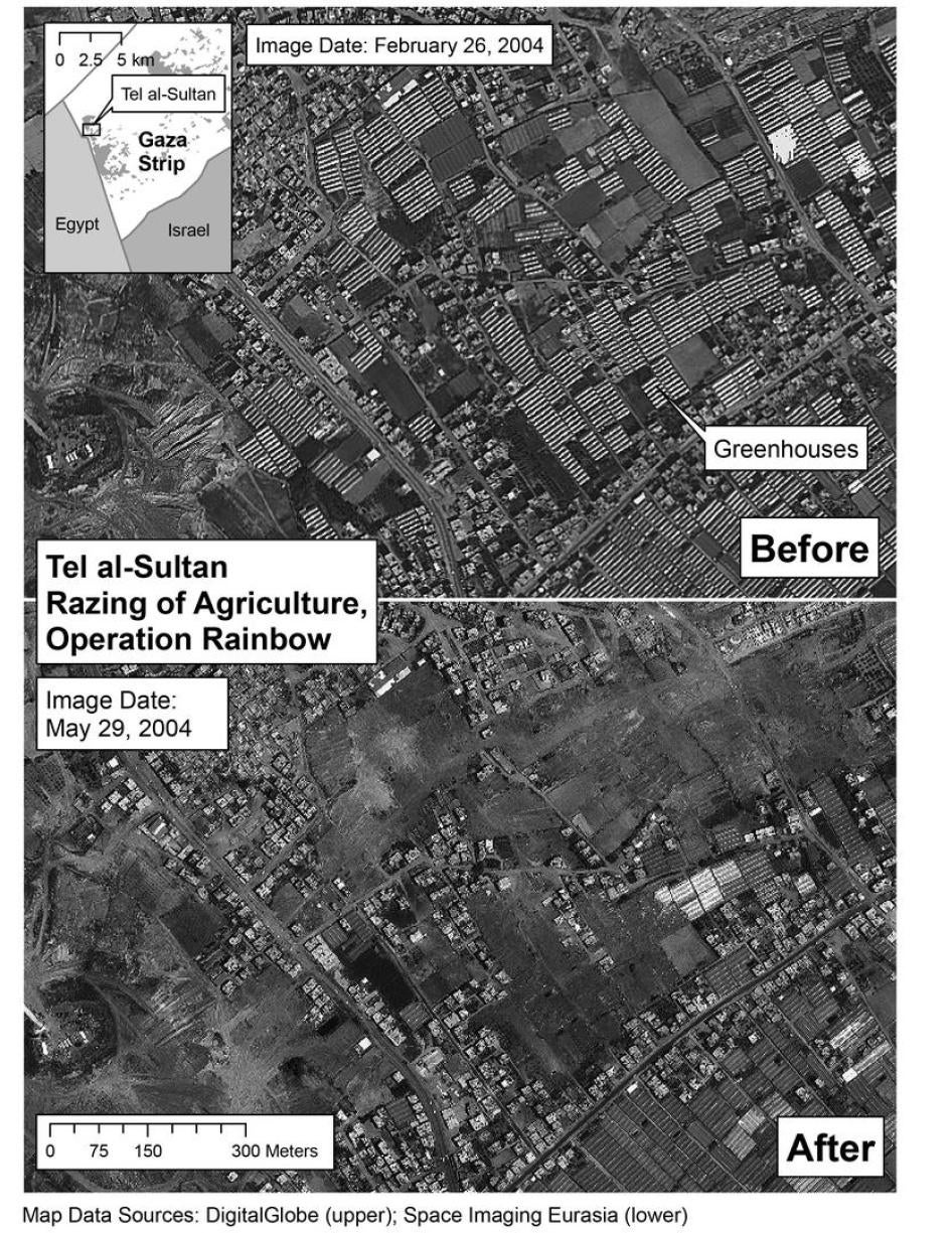
The destruction of agricultural land took place in a context in which military necessity could not have justified it.The area was under IDF control at the time of the destruction and resistance was minimal, if existent at all (see section above on Tel al-Sultan).Even if there had been resistance, it is unclear what military advantage destroying large swaths of agricultural land so far from the border would provide.
As with the destruction of roads and certain houses, the IDF invoked the threat of IEDs on roads to justify destruction of agricultural land: "IDF vehicles were forced to refrain from traveling on these roads and navigated through the surrounding fields, or other roads, instead," a letter from the spokesperson's office said.[278]While this explains why military vehicles may have traveled through fields, it does not explain why bulldozers spent at least two days systematically destroying every greenhouse in two large areas.
VII. ROLE OF THE INTERNATIONAL COMMUNITY
The international community's response to the May incursions was strong in words and weak on action.Still, near universal condemnation of the destruction from governments and organizations probably helped limit the Israeli abuse.
World leaders and major organizations strongly criticized Israel for the destruction of homes, property, and infrastructure in May (See Appendix) as well as the unlawful killing of civilians.The most forceful international criticism was Security Council Resolution 1544, passed on May 19, after the killings at the demonstration in Tel al-Sultan (see Box 4).With a vote of 14-0, the council called on Israel to respect international humanitarian law and, in particular, "its obligation not to undertake demolition of homes contrary to that law."The resolution also expressed "grave concern regarding the humanitarian situation of Palestinians made homeless in the Rafah area."
The lone abstention came from the United States, but even this was an unusually forceful U.S. response to Israeli violations.In the past, the U.S. has repeatedly blocked Security Council resolutions critical of its ally in the Middle East.Prior to the Security Council vote, Secretary of State Colin Powell had said the U.S. opposed "the kind of actions that they [the IDF] are taking in Rafah."[279]
Despite these strong positions, the U.S. government took no concrete steps to encourage Israel's compliance with international humanitarian law.On May 19 Israeli Deputy Prime Minister Ehud Olmert met National Security Adviser Condoleezza Rice and Secretary of State Powell to explain the Rafah offensive.He told the press after the meetings that he did not hear "the slightest criticism" from his interlocutors.[280]
Most important, U.S. funding continued to flow to the country's leading recipient of aid.The 2004 U.S. Foreign Appropriations Act allocated U.S. $2.15 billion to Israel for foreign military financing and U.S.$ 480 million for economic assistance, and none of this was placed in doubt.In 2003, the U.S. government also granted Israel U.S.$ 9 billion in loan guarantees to be dispersed over three years, part of which is intended to help defray debts from earlier guarantees.Some of the equipment Israel purchases with U.S. aid, like the Caterpillar D9 bulldozer, is used to commit the abuses described in this report.
The European Union is Israel's largest trading partner, with 22 billion in commerce between them in 2002.E.U.-Israel trade takes place under the framework of the E.U.-Israel Association Agreement; Article 2 of the Agreement stipulates that relations "shall be based on respect for human rights and democratic principles."Despite support in the European Parliament to suspend the Agreement due to Israel's human rights record, there has been little concrete action in this direction.[281]
Paying for the Mess
The Gaza Strip is heavily reliant on foreign aid, nearly U.S. $1 billion per year.[282]In Rafah, many of the essential programs and infrastructure are either heavily supported or completely funded by outside sources, like the European Union, U.S. government, Arab Development Bank, World Bank, and United Nations.These governments and organizations fund schools, water works, health care facilities, and offices of the PNA.
They also fund reconstruction for much of the destruction caused by the IDF, some of it of facilities these governments and organizations had funded in the first place.In June 2003, the World Bank estimated the IDF had damaged or destroyed U.S.$ 150 million worth of donor-funded infrastructure in Gaza and the West Bank since September 2000,[283] including the GazaAirport, PNA police installations, and UNRWA schools.[284]In January 2004, Israel paid compensation for damage to the contents of a WFP warehouse, the only known case of compensation for damage to donor-funded property.[285]
On May 31, UNRWA issued an appeal for U.S.$ 15.84 million for Rafah "to provide emergency cash, food and housing assistance to the hundreds of families who have lost their homes, had a breadwinner killed or wounded, or who are in need of ongoing medical care."[286]According to UNRWA, re-housing a family costs U.S.$ 20,000, and as of May 31 the agency had already spent U.S.$ 12,106,474 to provide accommodations for the displaced.[287]
As of August 29, UNRWA had built, was in the process of building, or had funding to build 430 dwelling units in Rafah, while projects for a further 1,464 units remained unfunded.The United Arab Emirates Red Crescent Society and the Saudi Committee for the Relief of the Palestinians have also pledged funds that could cover up to nine hundred units of this backlog, though details have yet to be finalized.[288]The PNA Ministry of Housing, which is primarily responsible for Rafah residents who are not refugees from what is now Israel, has built fifty-nine new housing units and is working on twenty more; thirty of the completed units, however, remain empty due to their proximity to the IDF base in Rafiah Yam settlement.[289]In the meantime, the number of new houses required continues to grow.
On August 11, the EC allocated 1.35 million specifically for victims of house demolitions in Rafah.The money is for temporary accommodations, cash assistance, shelter repairs, and key infrastructure, including the rehabilitation of water supply networks, sewage systems, and two schools, the EC said.Commenting on the decision, European Commissioner for Development and Humanitarian Aid Poul Nielson reminded Israel that "these funds do not absolve the occupying power of its responsibilities to uphold international humanitarian law."He added: "As reiterated by the European Union and the United Nations, house demolitions are disproportionate acts that contravene international humanitarian law, in particular the Fourth Geneva Convention, and show a reckless disregard for the lives of civilians."[290]The next day, the Islamic Development Bank said it would pay U.S.$ 25 million for reconstruction.[291]
The U.S. government has authorized the use of up to U.S.$ 20 million from the U.S. Emergency Refugee and Migration Assistance Fund to allow UNRWA to assist Palestinian refugees in the West Bank and Gaza.The State Department said on July 29 that the contribution was in response to UNRWA's U.S. $193 million emergency appeal for 2004.USAID had fast-tracked U.S. $100,000 to a local contractor to repair Rafah's water and sewage pipes and to replace the transformer at the Jumset Jabil pumping station.[292]
While this funding is desperately needed, the UNRWA appeal contributed to a debate within the aid community about funding the reconstruction for which Israel is obliged to pay.
"We are certainly prepared to continue our humanitarian assistance and to support the rebuilding of the infrastructure of those areas from which the Israel defense forces withdraw," said Chris Patten, European Commissioner for External Relations."But I have to say that this time I think we should seek certain guarantees from the Israeli defense forces that they will not destroy again what we build."[293]According to press reports, the U.S. government had sought such assurances in 2003 after some USAID-funded water wells in Rafah were destroyed.[294]
| Box 5: The Caterpillar D9 Armored Bulldozer
The Caterpillar D9 is the main IDF tool to demolish homes, structures, and agricultural areas in Gaza and the West Bank.The bulldozer is produced by Caterpillar Inc. and sold through the U.S. Foreign Military Sales Program.Armored plating is provided by state-owned Israel Military Industries (IMI). The Caterpillar D9 is a powerful track-type tractor manufactured primarily for construction or agricultural use.The front blade is more than 1.8 meters (six feet) high and 4.58 meters (fifteen feet) wide, and is designed to plow material, penetrate structures and carry loads.The IDF uses it to knock down walls, transport debris and plow for mines.On the bulldozer's back is the "ripper," used to loosen ground, remove stones and excavate ditches.The IDF also uses it to shred roads.Hydraulically controlled, the single shank blade can penetrate 1.7 meters (five feet, five inches) into the ground.[295] Nicknamed Duby, or "Teddy Bear", the Caterpillar D9 stands four meters (thirteen feet, one inch tall) and is more than 7.9 meters (twenty-six feet) long, including ripper and front blade.With armored plates, it weighs roughly sixty-four tons.On IDF-modified D9s, bulletproof glass surrounds the operator and heavy armor protects the external hydraulics. Caterpillar Inc., based in Peoria, Illinois, USA, claims to be the world's largest manufacturer of construction and mining equipment, diesel and natural gas engines, and industrial gas turbines.In 2003, the corporation (NYSE: CAT) posted sales and revenues of U.S. $22.76 billion and a profit of U.S. $1.1 billion.Approximately half of all sales were to customers outside the United States. The corporation and its chairman, Glen Barton, also claim to value social responsibility.According to Caterpillar's code of conduct: Wherever we conduct business or invest our resources around the world, we know that our commitment to financial success must also take into account social, economic, political, and environmental priorities. We believe that our success should also contribute to the quality of life and the prosperity of communities where we work and live.[296] Many corporations, governments, and international institutions recognize that corporations have an obligation to ensure respect for human rights and humanitarian law.Most recently, the United Nations has begun to develop standards for corporations in the form of the U.N. Norms on the Responsibilities of Transnational Corporations and Other Business Enterprises with Regard to Human Rights have.That document states that companies should not "engage in or benefit from" violations of international human rights or humanitarian law and that companies "shall further seek to ensure that the goods and services they provide will not be used to abuse human rights."[297]Despite the guidelines set out in the U.N. Norms and the company's own commitment to socially-responsible practices, Caterpillar has not taken meaningful steps to ensure that its products do not contribute to violations.In the case of the company's bulldozers, there is strong and credible evidence that they have been used for unnecessary and excessive house and property demolitions that amount to violations of international humanitarian law. Caterpillar does not appear to have implemented these principles with regard to bulldozer sales to Israel.Instead, the company claims it is not responsible for how its equipment is used.In response to complaints from the organization Jewish Voice for Peace about the bulldozers' use in illegal house demolitions, CEO James W. Owens wrote that Caterpillar has "neither the legal right nor the ability to monitor and police individual use of that equipment."[298]The claim was repeated verbatim in a Caterpillar statement on the Middle East."We believe any comments on political conflict in the region are best left to our governmental leaders who have the ability to impact action and advance the peace process," the statement said.[299] The letter from Owens further explainedthat Caterpillar's sales to Israel were conducted through the U.S. Foreign Military Sales Program (FMS), whereby the U.S. Department ofDefense purchases goods from U.S. manufacturers and resells them to foreign governments. In late May 2004, days after the major demolitions, the UN Special Rapporteur on the right to food, Jean Ziegler, wrote to Owens about Caterpillar bulldozers being used to "destroy agricultural farms, greenhouses, ancient olive groves and agricultural fields planted with crops, as well as numerous Palestinian homes and sometimes human lives."Delivery of the bulldozers to the Israeli government with knowledge that they were being used for illegal demolitions, Ziegler wrote, "might involve complicity or acceptance on the part of your company to actual and potential violations of human rights, including the right to food."[300] Human Rights Watch believes that Caterpillar's products have been used to further violations of international humanitarian law and that the company should take steps to ensure that this does not occur in the future.Such steps could include: agreeing to abide by standards such as the U.N. Norms and refusing to participate in the FMS program with Israel or to reject sales to governments or other parties where there is a risk that the company's products will be used in the perpetuation of human rights violations.Otherwise, Caterpillar will remain complicit in the international humanitarian law violations that occurred because of excessive and unwarranted demolitions by the Israeli government while using the company's bulldozers. |
VIII. PROPERTY DESTRUCTION UNDER INTERNATIONAL AND ISRAELI LAW
Israel's conduct in the OccupiedPalestinianTerritories (OPT) is regulated by two distinct but overlapping legal regimes: international humanitarian law (IHL) also known as the law of armed conflict and human rights law.Both regimes aim to enhance the protection of the civilian population, and in a complex situation such as a belligerent occupation, they complement and reinforce each other.
International Humanitarian Law
Under IHL, Israel is the Occupying Power in the West Bank and Gaza Strip.As such, it is bound by a subset of IHL that deals specifically with occupation, codified primarily in two legal instruments: the 1907 Hague Regulations[301] and the 1949 Fourth Geneva Convention.[302]As discussed in Chapter 3, Israel has rejected the applicability of the Fourth Geneva Convention to the OPT, a position that is not shared by the international community.
Since 2000, Israel has also argued that the uprising in the OPT constitutes an "armed conflict short of war" in which it can lawfully use military force but where the laws of international armed conflict do not fully apply since the IDF is not fighting a state.Maj. Noam Neuman, the IDF Deputy Legal Adviser in the Gaza Strip, summarized this position concisely: "Although we don't have the duty to obey all the rules as a policy we obey the laws of war."[303]In effect, Israeli authorities have tried to place themselves in a situation in which they are free to choose when they can invoke the privileges afforded by IHL while avoiding its responsibilities.[304]
While there have been a series of armed engagements throughout both the OPT and Israel, Israel still retains overall effective control in the OPT and is therefore bound by the duties of an Occupying Power, as well as its obligations under international human rights law.
Responsibilities of an Occupier: Military Operations vs. Security Measures
An Occupying Power has two roles: as an administrator with security responsibilities, and as a potential belligerent in the event of fighting.The Occupying Power is always responsible, however, for protecting the civilian population in its hands.[305]
As an administrator responsible for maintaining law and order, an Occupying Power can take preventive measures to enhance the security of its forces, such as patrols, fortifications, checkpoints, and taking control of private property.
Adopting preventive security measures entails assessment of potential risks rather than direct and actual threats.These measuresare by definition taken outside of a context of fighting or preparations for battle. In this situation, a fuller range of human rights protections and due process guarantees should apply.The Israeli Supreme Court has heard cases involving house demolitions for decades, but it has consistently sanctioned policies that violate both human rights law and IHL.
In the event of hostilities, an Occupying Power may also engage in military operations, which the Commentary to the Additional Protocols to the Geneva Conventions defines as "movements, manuvres and actions of any sort, carried out by the armed forces with a view to combat."[306]A belligerent occupation cannot be considered a "military operation" in itself, nor can every activity conducted by the Occupying Power be considered a military operation.Rather, military operations must be concretely linked to fighting.
IHL strictly limits the destruction of property to military operations.According to Article 53 of the Fourth Geneva Convention, "Any destruction by the Occupying Power of real or personal property belonging individually or collectively to private persons, or to the State, or to other public authorities, or to social or cooperative organizations, is prohibited, except where such destruction is rendered absolutely necessary by military operations" [emphasis added].General security measures not connected to actual fighting are not included in this exception.[307]For this reason, the ICRC stated during the May incursions in Rafah that "the destruction of property as a general security measure is prohibited."[308]Article 53 adapts Article 23(g) of the Hague Regulations, which is now recognized as customary law by the Israeli Supreme Court, more restrictively to occupation.[309]Article 23(g) forbids destruction or seizure of property unless "imperatively demanded by the necessities of war."One leading commentator argues that:
not everysituation of military necessity but only imperative reasons of military necessity, i.e. most serious military reasons which are of an imperative nature, may justify [destruction or seizure of property]. Accordingly, the pure fact that the acts under consideration do serve security needs or contribute to the security of the area at large is not in itself sufficient to justify any of the otherwise prohibited acts, unless it can be proven that there is indeed an imperative need to do so, i.e. that there are no other means to secure military safety.In particular, national-security needs in a broad sense may not justify takings or private property.[310]
As documented in this report, the IDF frequently destroyed houses, roads, and agricultural land for reasons not linked to combat.The most widespread demolitions have been in the context of the expansion of the buffer zone.Other demolitions have proceeded on the basis of a general assumption, without verification, that roads are mined.Houses near the border used in past attacks have also been destroyed, usually accompanied by an internal legal review."We destroy a house if it was used [against us] before and as long as we think it will be used again," said Major Neuman.[311]The IDF has also spoken of other non-combat rationales for mass demolition, including "weaken[ing] the fear of the existence of tunnels."[312]
IDF doctrine appears to inappropriately conflate military operations linked to fighting with security measures intended to reduce the general risk to the Occupying Power.This inherently expansive interpretation of military operations, with the broader latitude for destruction, has been a recipe for incremental expansion of the buffer zone as well as for excessive destruction during incursions into the camp.As one IDF officer put it, "I have no doubt that the clearing actions [i.e. house demolition and land razing] have an element of tactical value, but the question is, where do we draw the line?According to that logic, what prevents us from destroying Gaza?"[313]
Destruction of Property in Occupation: Military Operations and Absolute Necessity
Once engaged in military operations in other words, actions taken with a view to fighting an occupying power can destroy property only "when rendered absolutely necessary by military operations."Military necessity is one of the most difficult concepts to define under IHL, as too broad a definition could easily undermine many IHL norms and revert to an unacceptable "everything is fair in war" standard.The Commentary to the Fourth Geneva Convention is especially aware of this danger with regard to property destruction and expresses concern that "unscrupulous recourse to the clause concerning military necessity would allow the Occupying Power to circumvent the prohibition set forth in the Convention."[314]
In the case of property destruction, military necessity must be "absolute," which the ICRC has interpreted to mean "materially indispensable" in the framework of military operations.[315]The Canadian military manual's section on occupation stipulates that:
Property of any type or ownership may be damaged when such is necessary to, or results from, military operations either during or preparatory to combat.Destruction is forbidden except where there is some reasonable connection between the destruction of the property and the overcoming of the enemy forces.[316]
Similarly, the U.S. military field manual's regulations for destruction in the context of hostilities require a "reasonably close connection between the destruction of property and the overcoming of the enemy's army" [emphasis added].[317]The U.K. military manual is more explicit in a reference to conduct in recently captured areas, where the army has not yet established the degree of control required for an occupation:
once the defended locality has surrendered or been captured, only such further damage is permitted as is demanded by the exigencies of war, for example removal of fortifications, demolition of military structures, destruction of military stores, or measures for the defence of the locality.It is not permissible to destroy a public building or private house because it was defended [emphasis added].[318]
The IDF manual on the laws of war on the battlefield interprets military necessity and property destruction much more permissively:
The Hague Conventions state that unnecessary destruction of enemy property is forbidden. The emphasis here is on unnecessary, for as opposed to [sic] civilians, there is no absolute protection of property in wartime.It is only natural that property sustain damage in war.The only restriction is to refrain from destroying property senselessly, where there is no military justification, for the sheer sake of vandalism [emphasis in the original].[319]
Under this standard, any destruction that could have some hypothetical military value is permitted.There is no mention of the need for "absolute" necessity required in contexts of occupation.Indeed, the IDF manual does not even establish that the destruction must conform to other rules of IHL.Yet one of the oldest and most widely accepted definitions of military necessity states that it consists of "measures which are essential to attain the goals of war, and which are lawful in accordance with the laws and customs of war."[320]In other words, military necessity cannot be used as an excuse to violate explicit IHL provisions, because the requirements of military necessity have already been incorporated into IHL rules.The military manuals of the U.S., U.K., Canada, and other major armies emphasize this point but it does not appear anywhere in the IDF manual.[321]
In explaining house demolitions during military operations, Israeli officials frequently cite the example of civilian houses being used to shelter gunmen while they attack the occupying army.[322]The IDF's guidelines for permissible demolition, however, encompass far more than this example.During the May 18-24 incursions, the IDF said that it also destroyed homes if trip wires for explosives originated from them, if "terrorists" resided in them, or if they covered tunnel entrances.[323]The IDF field commander reportedly indicated that he also considered any house from which an armed person emerged to be a military target.[324]Finally, the IDF acknowledges destroying homes on a preventive, hypothetical basis during incursions.According to Major General Dan Harel, head of the Southern Command, "20 structures were demolished around the uncovered tunnels, this in order to prevent terrorists from opening fire and activating explosive devices against the operating forces."[325]
These broad criteria for house demolitions, undoubtedly shaped by the disturbingly permissive interpretation of military necessity in the IDF military manual, undermine two fundamental principles of IHL: distinction and proportionality.
The principle of distinction is enshrined in the duty to "at all times distinguish between civilian objects and military objectives" and to accordingly direct "operations only against military objectives."[326]In a meeting with Human Rights Watch researchers, Major Neuman said that the IDF only destroys civilian homes that have become military objectives.To stress the point, he read out loud Article 52(2) of Additional Protocol I, which stipulates that military objectives can include objects "which by their nature, location, purpose or use make an effective contribution to military action and whose total or partial destruction, capture or neutralization, in the circumstances ruling at the time, offers a definite military advantage."
The next provision (Article 52(3)), however, makes clear that the mere potential for military use does not eviscerate the protection enjoyed by a civilian object: "In case of doubt whether an object which is normally dedicated to civilian purposes, such as a place of worship, a house or other dwelling or a school, is being used to make an effective contribution to military action, it shall be presumed not to be so used."As a result, it is unlawful to destroy a civilian object without sufficient evidence that it is being put to military use or is about to be so used.The U.K. military manual illustrates the rule with the following example: "If, for example, it is suspected that a schoolhouse situated in a commanding tactical position is being used by an adverse party as an observation post and gun emplacement, this suspicion, unsupported by evidence, is not enough to justify an attack on the schoolhouse."[327]Similarly, civilian objects used for military purposes only lose their civilian status for as long as they make an effective contribution to military action.
Even when a clear military objective has been identified, an occupying power also "must try to keep a sense of proportion in comparing the military advantages to be gained with the damage done."[328]Proportionality dictates that the civilian cost of a military action should not be excessive in relation to the concrete and direct military advantage anticipated.The phrase "concrete and direct" appears several times in Additional Protocol I and in various expressions of customary international law.The U.K. manual interprets the phrase to mean that "the advantage to be gained is identifiable and quantifiable and one that flows directly from the attack, not some pious hope that it might improve the military situation in the long term."[329]An IDF legal advisor explained to Human Rights Watch that the military assesses the proportionality of house demolitions primarily by taking into account whether a building is inhabited.This determination is often made on the basis of intelligence reports or soldiers' observations of inhabitation signs, such as internal lights or hanging laundry.[330]
Using the category of "uninhabited" homes as the main yardstick of proportionality, however, ignores the fact that IDF shelling or incursions are often the reason for civilians to temporarily vacate their homes in the first place.The mere absence of people from a building at a particular moment in time does not make it uninhabited, especially when the residents have been compelled to flee by hostilities.Moreover, it is not enough simply to ensure that civilians are not physically harmed; the principle of distinction also applies to civilian objects, including property.In particular, an attacker should refrain from launching an attack if the expected cost, including "damage to civilian objects would be excessive in relation to the concrete and direct military advantage anticipated."[331]Protocol I, Article 57 ("Precautions in attack") requires those who plan and/or execute an attack to cancel or desist from the attack in such circumstances.In theory, an abandoned home has less value in a proportionality analysis than an inhabited one.But the IDF's assessment of proportionality must be considered in light of the indiscriminate shooting that is a feature of daily life along the Rafah border.
"Extensive destruction and appropriation of property not justified by military necessity and carried out unlawfully and wantonly" is a grave breach of the Fourth Geneva Convention, or a war crime.[332] As the first international judicial institution to try cases of destruction as a grave breach of the Geneva Conventions, the International Criminal Tribunal for ex-Yugoslavia (ICTY) has determined that such a crime has been committed when property is destroyed extensively and without military necessity, and if the perpetrator acted with the intent to destroy the property or in reckless disregard of the likelihood of its destruction.[333]
Control of Property in Occupation: Security Measures and Rights
While IHL strictly regulates the destruction of all kinds of property, an Occupying Power may take control of property under a number of different circumstances.Nevertheless, it is difficult to reconcile the planned expansion of the buffer zone with any of them.
According to Article 23(g) of the Hague Regulations, seizure of property is forbidden unless "imperatively demanded by the necessities of war."As this provision is located in the section of the Hague Regulations on hostilities (rather than occupation), it is relevant only in the context of military operations and is also subject to the recognized limitations on military necessity.
An Occupying Power cannot confiscate private property.[334]It can requisition use of buildings for the maintenance of the army of occupation, in proportion to the resources of the territory.[335]It also acts as an administrator of public buildings and lands, but cannot reduce their value.[336]As an administrator, an Occupying Power may also expropriate property for public use as part of its obligation to maintain civic life.[337]According to the U.S. army field manual, "an occupant is authorized to expropriate either public or private property solely for the benefit of the local population."[338]
The U.S. and Canadian military manuals argue that an Occupying Power is also allowed to control property "to the degree necessary to prevent its use for the benefit of the enemy or in a manner harmful to the occupant.Property control is temporary in nature.The property must be returned to the owners when the reason for the control no longer exists.Therefore, the control must not extend to confiscation."[339]
The IDF manual says that "Private property that does not belong to the state is immune to seizure and conversion to booty.Nevertheless, a military commander is allowed to seize [sic] also private property if this serves an important military need."[340]As with IDF doctrine on destruction, this provision does not require that seizure be in conformity with IHL.None of the limitations and restrictions associated with property control stipulated in the Hague Regulations such as the requirement that seizure be "imperatively demanded by the necessities of war" or that requisitions be in proportion to the resources of the territory are mentioned.Nor does the manual mention that control of private property for military use should be temporary.
Human Rights Law and Occupied Territories
Unlawful house demolitions and expulsions also violate fundamental human rights norms that continue to apply in situations of belligerent occupation.International human rights law seeks to protect individuals from forced evictions and guarantees the right to adequate housing even when they are lawfully removed.It also guarantees individuals the right to adequate remedies, which should include access to impartial courts to seek compensation for destroyed property or to challenge the legality of property seizures.Whether the IDF desires to expand the buffer zone through incremental incursions or to widen it after going through the Israeli Supreme Court, these fundamental rights should be respected and should also inform policy.
While Israel has ratified the International Covenant for Civil and Political Rights (ICCPR) and the International Covenant for Economic, Social, and Cultural Rights (ICESCR), it denies their applicability to the OPT.Israel has argued that these treaties apply only to Israel's sovereign territory, that the establishment of the PNA should relieve it of its international responsibilities under these covenants in the OPT, and that the existence of hostilities in the OPT merits the application of IHL at the exclusion of human rights norms.[341]The ICCPR, however, explicitly applies to "all individuals within [a state's] territory and jurisdiction" (Article 2(1)), which would include Palestinians in the OPT.U.N. treaty bodies have repeatedly affirmed Israel's responsibilities under these human rights instruments in the OPT, as has the ICJ.[342]As the U.N. Human Rights Committee affirmed in its most recent concluding observations on Israel:
The Committee reiterates the view that the applicability of the regime of international humanitarian law during an armed conflict does not preclude the application of the Covenant The Committee therefore reiterates that, in the current circumstances, the provisions of the Covenant apply to the benefit of the population of the Occupied Territories, for all conduct by the State party's authorities or agents in those territories that affect the enjoyment of rights enshrined in the Covenant and fall within the ambit of State responsibility of Israel under the principles of public international law.[343]
Similarly, the U.N. Committee on Economic, Social, and Cultural Rights has repeatedly stressed in relation to Israel and the OPT that "even in a situation of armed conflict, fundamental human rights must be respected and that basic economic, social and cultural rights, as part of the minimum standards of human rights, are guaranteed under customary international law and are also prescribed by international humanitarian law."[344]
IHL also recognizes the continued relevance of human rights in belligerent occupation.The Fourth Geneva Convention balances the protections afforded to civilians against the right of the Occupying Power to take security measures. "The various security measures which States might take are not specified," notes the ICRC Commentary to the Fourth Geneva Convention."What is essential is that the measures of constraint they adopt should not affect the fundamental rights of the persons concerned.As has been seen, those rights must be respected even when measures of constraint are justified."[345]
Forced Evictions and the Right to Adequate Housing
International law seeks to protect people from forced eviction, which has been defined as "the permanent or temporary removal against their will of individuals, families and/or communities from the homes and/or land which they occupy, without the provision of, and access to, appropriate forms of legal or other protection."[346]The U.N. Commission on Human Rights in 1993 concluded that "forced evictions are a gross violation of human rights, in particular the right to adequate housing."[347]
International human rights bodies have sought to limit the scope for allowable forced evictions as much as possible.The U.N. Committee on Economic, Cultural and Social Rights (CESCR) considers "that instances of forced eviction are prima facie incompatible with the requirements of the [ICESCR] and can only be justified in the most exceptional circumstances, and in accordance with the relevant principles of international law."[348]
Forced evictions occur in both peacetime and in the context of armed conflict.[349]States are prohibited from carrying out forced evictions in all areas under their control, including those under belligerent occupation.[350]
Forced evictions and unlawful house demolitions also constitute a form of arbitrary interference with the home, which is prohibited by Article 17 of ICCPR.It is important to note that even the removal of people from their homes through a legal process can violate this rule:
In the Committee's view the expression "arbitrary interference" can also extend to interference provided for under the law. The introduction of the concept of arbitrariness is intended to guarantee that even interference provided for by law should be in accordance with the provisions, aims and objectives of the Covenant and should be, in any event, reasonable in the particular circumstances.[351]
Even in situations where individuals may lawfully be removed from their homes, the right to adequate housing, guaranteed by Article 11(1) of ICECR, remains.[352]Unlike many civil and political rights, it cannot be derogated from in the name of national security.It can be subject "only to such limitations as are determined by law only in so far as this may be compatible with the nature of these rights and solely for the purpose of promoting the general welfare in a democratic society."[353]As the CESCR explains, "the right to housing should not be interpreted in a narrow or restrictive sense which equates it with, for example, the shelter provided by merely having a roof over one's head or views shelter exclusively as a commodity.Rather it should be seen as the right to live somewhere in security, peace and dignity."[354]As the Occupying Power, even if Israel enacts a legal process to remove Palestinians from their homes, it must ensure that they are adequately housed.
Right to Effective Remedies
An Occupying Power should make available effective remedies to those whose property has been destroyed.It should also ensure that property control measures do not amount to de facto confiscation by taking such measures only in response to specific and well-defined threats, and allowing owners to legally challenge decisions before impartial bodies on a regular basis.
Article 2(3) of ICCPR guarantees the right to "effective" remedies for those whose rights have been violated.States are obligated "To ensure that any person claiming such a remedy shall have his right thereto determined by competent judicial, administrative or legislative authorities, or by any other competent authority provided for by the legal system of the State, and to develop the possibilities of judicial remedy."They must also "ensure that the competent authorities shall enforce such remedies when granted."
In relation to forced evictions, the CESCR has also stressed the importance of consultation and access to legal remedies:
States parties shall ensure, prior to carrying out any evictions, and particularly those involving large groups, that all feasible alternatives are explored in consultation with the affected persons, with a view to avoiding, or at least minimizing, the need to use force.Legal remedies or procedures should be provided to those who are affected by eviction orders.States parties shall also see to it that all the individuals concerned have a right to adequate compensation for any property, both personal and real, which is affected.[355]
As noted above, the existence of a belligerent occupation or even of armed conflict does not automatically preempt the right to an effective remedy.It is noteworthy that even assigned residence and internment, described in Article 78 as the Fourth Geneva Convention as the most severe security measures allowed to an Occupying Power, require a number of procedural safeguards, most notably the right to appeal.Appeals shall be decided on with the least possible delay and assigned residence or internment should be subject to review every six months if possible.[356]Furthermore, fifty-seven of the 159 articles of the Convention (Arts. 79-135) are exclusively dedicated to regulating various aspects of internment.The Commentary on Article 78 notes that "such measures can only be ordered for real and imperative reasons of security; their exceptional character must be preserved."[357]
Israeli Jurisprudence and Law
For decades, Israel's judiciary has effectively sanctioned unlawful property destruction and forced evictions by the IDF.This does not bode well for the prospects of a plan to legalize the destruction of homes in order to widen the Philadelphi corridor.Simply destroying homes and handing out compensation, as has been discussed in the Israeli media, is not enough; residents must be able to mount legal challenges to expropriation with full human rights guarantees.
Exceptions Over the Rule: Israeli Courts and Destruction of Property
For decades, the Israeli Supreme Court has heard petitions related to property destruction, mostly in the context of urgent petitions filed regarding punitive demolitions.The Court has consistently legitimized house demolitions[358] while developing a limited and deeply flawed jurisprudence regarding the right of owners to be heard in advance of demolitions.
The Israeli Supreme Court has in recent years expanded the scope of the IDF's discretion to dispense with the right to a hearing.For years, demolitions could go ahead without a hearing if imperative military reasons, usually linked to combat, allowed.During the current uprising, other exceptions were added.The 2002 'Amer case represents the latest evolution in the Court's jurisprudence on the right of an owner to be heard in advance of demolitions.The Court ruled that the right could be revoked in three instances:
- If destruction is absolutely necessary for military operations;
- If providing advance notice would endanger the lives of soldiers;
- If providing advance notice would endanger the success of the demolition.[359]
The cumulative effect of the "three exceptions" rule is to give the IDF discretion to circumvent the already limited role of the Court and to avoid having to justify demolitions in the first place.The first "exception" conforms to the general rule for destruction under IHL.The second "exception" has been proposed by the IDF on the basis that giving advance notice can entail significant risks to troops, for example by allowing the homes in question to be booby-trapped with explosives or giving fighters an opportunity to set up ambushes.While this may be possible in some cases, the court's jurisprudence is vague about the level and nature of the risks required to render such destruction "absolutely necessary" for military operations.The third exception is so vague that it allows for demolitions without due process on almost any basis.
Even if none of the three exceptions apply, the "right to be heard" granted by the Court is not an adequate remedy.There are no clear guidelines for the appeal process, and the Court invariably defers to the IDF's invocation of "military necessity."Even when faced with expert opinions on the military necessity or efficacy of proposed actions, the Court as a rule sides with the IDF without assessing the merits of competing arguments.As the Israeli Supreme Court ruled in 1979 and reaffirmed as recently as June 2004:
In security issues, where the petitioner relies on the opinion of an expert in security affairs, and the respondent relies on the opinion of a person who is both an expert and also responsible for the security of the state, it is natural that we will grant special weight to the opinion of the latter.[360]
According to human rights lawyers who litigate house demolition cases, appeals to the Court at best elicit temporary injunctions that give residents several hours or days to evacuate their belongings.Occasionally, the IDF announces that it has no intention of demolishing the homes in question for the time being, leaving residents in fear that the threat of demolition could reemerge later.In conceding that it has the luxury to carry out some demolitions later on at its convenience, the IDF undermines any argument for the "absolute" necessity of such destruction.[361]
The jurisprudence of the "three-exception" rule was mostly developed in the case of punitive house demolitions, i.e. in cases where the IDF did not claim any security or military threat from the houses themselves.In cases such as in Rafah, where the IDF claims that houses are actually military objectives, there is virtually no space for appeals.Israeli State Attorney Aner Hellman has essentially argued that at least one of the three exceptions exists at nearly all times in Rafah: "In 99 percent of the cases in the Rafah area, which is different from the West Bank or elsewhere in the Gaza Strip, the moment we announce our intention of razing a home, the Palestinians immediately set booby-traps there."[362]As one Israeli commentator noted, the Court effectively "hear[s] petitions by Palestinian residents calling for the right of appeal, and hand[s] down decisions which seem to offer a certain degree of hope even though both sides, the court and the petitioners, know the hope is hollow."[363]
The vast permissiveness that the "three exceptions" rule permits the IDF in property destruction has prompted a change in litigation tactics by local human rights organizations.In May, three groups Adalah, al-Haq, and the Palestinian Centre for Human Rights (PCHR) jointly filed a petition to the Israeli Supreme Court asking it to define the scope of "military necessity" regarding property destruction under IHL.The human rights groups argued that "The Supreme Court's failure, to date, to precisely define the limitations of 'military necessity' has contributed to the Israeli army's implementation of a policy of extensive home demolitions throughout the 1967 Occupied Territories, exploiting the pretext of this exception as justification for its actions."[364]As of September 2004, the Court had not responded on whether it will hear the petition.
Pending a decision on the petition, the three groups filed a motion to the Court on June 30 for an injunction to prevent the demolition of the homes of ten families in various high-risk neighborhoods of Rafah.On July 21, Judge Mishael Cheshin issued an order forbidding the destruction of the ten homes mentioned in the motion, but the Court canceled the order several hours later.The reversal came after the Attorney General argued that the military could not locate the ten houses in question and that military operations in southern Rafah are continuing in which soldiers' lives are at risk.Furthermore, the State Attorney assured the Court that the houses will not be demolished without a hearing subject, of course, to the "three exceptions" rule.[365]
Reparations
Under IHL, reparation is required for violations, though not for damage that is incidental to lawful military acts.Israeli law, however, makes obtaining compensation for IDF abuses, including unlawful property destruction, almost impossible.[366]In July 2002, the Knesset amended the law on claims related to IDF activities in the OPT, sharply curtailing the already limited ability of civilians to obtain compensation for damage or injury caused by negligent or unlawful acts of Israeli forces.[367]
Under the previous law, the state was exempt from any liability in connection with "wartime action."The 2002 amendment expanded the definition of "wartime action" from actual hostilities to include virtually all IDF activities in the OPT, including those not related to combat, such as patrols, operating checkpoints, searches and arrests, and dealing with demonstrations.The law also places the burden of proof on the plaintiff and drastically reduces the time period in which cases can be brought.[368]According to a coalition of Israeli human rights groups, the amendment "renders worthless the rules of Israeli law and international law that are intended to limit the use of force. Violation of the law would bear no consequences, and enforcement of the law would be subject solely to the good will of the soldiers."[369]
IX. Appendix: Statements by International Community Condemning Destruction in Rafah
"The Secretary-General strongly condemns Israel's ongoing and widespread destruction of Palestinian homes in Rafah in the southern Gaza Strip. Reports cite the demolition of scores of buildings over the last two days, in addition to 130 residential buildings already destroyed this month. The Secretary-General has repeatedly called on the Government of Israel to address its security needs within the boundaries of international law. He urges Israel to uphold its obligations as an occupying Power by immediately halting such actions, which are tantamount to collective punishment and a clear violation of international law."
May 14, 2004, Spokesman for U.N. Secretary-General Kofi Annan
"We are extremely alarmed that even more demolitions are planned. Already huge swathes of Rafah have been flattened, to the extent that some families have experienced the trauma of demolition more than once. With these disproportionate military operations, Israel is in grave breach of international humanitarian law. This collective punishment can do nothing to calm the situation in Gaza or enhance Israel's own security."
May 15, 2004, Peter Hansen, UNRWA Commissioner-General
"The Secretary-General reiterates his condemnation of Israel's widespread destruction of Palestinian homes in Rafah in the Gaza Strip. Recent reports from UN agencies assert that some 2,197 people have lost their homes in the first 15 days of May. In addition, there are reports of Israeli military plans for a more extensive round of house demolitions in Gaza. He repeats his call on the Government of Israel to fulfil its obligations under international law as it acts to ensure its security. As the occupying Power, it must cease such acts of collective punishment immediately, and refrain from further grave violations of international law."
May 17, 2004, Spokesman for U.N. Secretary-General Kofi Annan
"We understand Israel's need to defend itself from attacks, but as a matter of policy we oppose the use of home demolitions to achieve this end and we are concerned about the humanitarian consequences of such demolitions."
May 17, 2004, Spokesman for the American Embassy in Israel
"We, the undersigned international humanitarian organizations, find this situation unacceptable. We are appalled by Israeli Government plans to continue demolitions on this large scale and 'create a new reality on the border between Egypt and Gaza' as stated by Shaul Mofaz, the Israeli Defense Minister on May 16th 2004 in a cabinet meeting."
May 18, 2004, Association of International Development Agencies (AIDA)
"It is clear that today's action was completely disproportionate to any threat faced by the Israeli military and that Israeli forces showed a reckless disregard for human life.I would once again remind Israel, the occupying power, that the fourth Geneva Convention relative to the Protection of Civilian Persons in Time of War is fully applicable to the Gaza Strip."
May 19, 2004, Irish Minister for Foreign Affairs, Mr. Brian Cowen T.D., speaking as President of the Council of the European Union
"These actions constitute a violation of international humanitarian law and constitute war crimes under Article 147 of the Geneva Convention relative to the Protection of Civilian Persons in Time of War, of 12 August 1949 (Fourth Geneva Convention).They also amount to collective punishment which violates both humanitarian law and international human rights law.It is impossible to accept the Israeli argument that these actions are justified by military necessity.On the contrary, in the language of Article 147 of the Fourth Geneva Convention, they are "carried out unlawfully and wantonly."
May 19, 2004, John Dugard, Special Rapporteur of the Commission on Human Rights on the situation of human rights in the Palestinian territory occupied by Israel since 1967
"UNRWA calls on the IDF to halt its demolition of houses immediately and discontinue the humanitarian tragedy it is wreaking on the largely civilian population of Rafah.UNRWA fully recognizes the right of the State of Israel to defend itself and its people. The military actions of the last few days are in violation of Israel's obligations under international law and will do nothing to safeguard Israel's security or facilitate the resumption of serious attempts to find a solution to the conflict."
May 20, 2004, UNRWA statement
ACKNOWLEDGEMENTS
This report was researched and written by Fred Abrahams, senior researcher with Human Rights Watch; Marc Garlasco, Senior Military Analyst in the Arms Division; and Darryl Li, Finberg Fellow.It was edited by Sarah Leah Whitson, Executive Director of the Middle East and North Africa Division and Widney Brown, Deputy Program Director.The report was reviewed by Wilder Tayler, Legal and Policy Director, and by Kenneth Roth, Executive Director of Human Rights Watch.Parts of this report were also reviewed by Steve Goose, Director of the Arms Division and Arvind Ganesan, Director of the Business & Human Rights Program.Leila Hull, Associate in the Middle East and North Africa Division, provided invaluable research and production assistance.InternsMarie Yared and Alicyn Cooley in the Middle East and North Africa Division and Sarah Davis and Javier Stark in the Arms Division provided research assistance.Eitan Buchwall, intern in the Middle East and North Africa Division, helped prepare the production and release of the report.Thanks also to Corinne Carey, Researcher in the U.S. Program, for legal advice.Satellite imagery was generously provided by Space Imaging North America, Space Imaging Eurasia, Space Imaging Middle East, and Digital Globe.Matthew McKinzie, produced the maps, photographs were taken by Marc Garlasco and Fred Abrahams.
Human Rights Watch thanks two groups of people for their invaluable help.First, the, victims and witnesses who gave testimony that form the report's core.Second, the human rights organizations in Israel and the Occupied Territories working on house demolitions and property destruction, including Adalah, B'tselem, HaMoked, al-Haq, al-Mezan Center for Human Rights, and the Palestinian Centre for Human Rights.Particular thanks go to Mohamed Abdallah, Abd al-Halim Abu Samra, Yusuf Ibrahim, and Jaber Wishah.Adwan Adwan and Mohammed Asfour were excellent translators and guides.
At the United Nations, both UNRWA and OCHA provided very useful assistance.Special thanks to Christer Nordahl and Maher Nasser of UNRWA for providing statistical and cartographic data.Human Rights Watch is also grateful for the cooperation it received from the Israeli government, including Orli Gil at the Israeli Ministry of Foreign Affairs, Maj. Noam Neuman of the IDF legal adviser's office, Maj. Assaf Librati of the Southern Command, and Maj. Sharon Feingold and Maj. Sam Wiedermann of the IDF Spokesperson's Unit.
[1] Voice of Israel Radio, January 16, 2002, cited in B'tselem, Policy of Destruction: House Demolitions and Destruction of Agricultural Land in the Gaza Strip, February 2002.
[2]Tsadok Yehezkeli, "Regards from Hell," Yediot Ahronoth, June 11, 2004 (Hebrew).
[3] Unless otherwise stated, statistics for homes demolished and persons rendered homeless were provided by the United Nations Relief and Works Agency for Palestine Refugees in the Near East (UNRWA) based mostly on assessments by its social workers.UNRWA classifies damage in three categories: total destruction, partial destruction (rendered uninhabitable, in need of reconstruction), and damage (habitable, in need of repair).References to homes "demolished" or "destroyed" in this report refer to all those rendered uninhabitable, i.e. the first two categories, unless otherwise stated.UNRWA statistics also include data on the demolition of non-refugee homes.
[4] UNRWA's operational definition of "refugee" includes descendents of those who fled or were expelled from what became Israel ("Who is a Palestine refugee?" UNRWA website, available at http://www.un.org/unrwa/refugees/whois.html, accessed September 24, 2004).
[5] Human Rights Watch has extensively documented this practice in recent years.See In a Dark Hour: The Use of Civilians During IDF Arrest Operations (Human Rights Watch, April 2002).
[6] Human Rights Watch interview with Ibrahim Abu Shittat, Rafah, July 13, 2004.
[7] Palestinian Central Bureau of Statistics, http://www.pcbs.org/martyrs/table1_e.aspx, (accessed October 4, 2004).
[8] Figures on Israeli fatalities are drawn from the website of the Israeli Ministry of Foreign Affairs, www.mfa.gov.il. (accessed October 4, 2004) In response to an inquiry from Human Rights Watch, the IDF did not disclose figures on injuries in Rafah.
[9] While major militaries affirm the right of an occupying power to temporarily control property for security purposes, confiscation (permanent seizure and transfer of ownership) is prohibited by Article 46 of the Hague Regulations.
[10] Avihai Becker, "The Black List of Captain Kaplan," Ha'aretz, April 27, 2001, cited in B'tselem, Policy of Destruction: House Demolitions and Destruction of Agricultural Land in the Gaza Strip, February 2002, p. 34.
[11] Because in this investigation HRW focused on the pattern of property destruction, figures on deaths were compiled from an analysis of reporting by local human rights organizations, media accounts, and statements by Palestinian armed groups, supplemented in some cases by Human Rights Watch's own documentation.
[12] Fourth Geneva Convention, Art. 53.
[13] ICRC, Commentary to the Protocol Additional to the Geneva Conventions of 12 August 1949, and relating to the Protection of Victims of International Armed Conflicts (Protocol I), 8 June 1977, p. 67.See virtually identical language in "Interpretation by the ICRC of Article 53 of the Fourth Geneva Convention of 12 August 1949, with particular reference to the expression 'military operations,'" Letter to al-Haq signed by Jacques Moreillon, Director of Department of Principles and Law and Jean Pictet, ICRC, November 25, 1981 (" with a view to fighting") and "Occupation and international humanitarian law: questions and answers," ICRC press release, August 4, 2004 ("when absolutely required by military necessity during the conduct of hostilities").
[14] "ICRC Deeply Concerned Over House Destructions in Rafah," ICRC press release, May 18, 2004.
[15] "Transcript of GOC Southern Command Regarding the Findings of the Investigation of the Demolition of the Buildings in Rafah (10-11.01.02)," IDF Spokesperson's Unit, January 27, 2002.
[16]Sharon wrote in his memoirs that "it was essential to create a Jewish buffer zone between Gaza and the Sinai [then under Israeli control] to cut off the flow of smuggled weapons and looking forward to a future settlement with Egypt to divide the two regions" (Warrior: The Autobiography of Ariel Sharon (New York: Simon & Schuster, 2001), p. 258).
[17]Laws of War in the Battlefield (IDF Military Law School, Department of International Law, 1998), p. 69.The manual is available in English at http://www.ihlresearch.org/opt/bounce.php?a=12623, (accessed October 4, 2004).
[18] See, inter alia, U.S. Army Field Manual 27-10: The Law of Land Warfare (Department of the Army, July 1956), p. 4; The Manual of the Law of the Law of Armed Conflict (Oxford: Oxford University Press, 2004), pp. 21-23; The Law of Armed Conflict at the Operational and Tactical Level (Office of the Judge Advocate General, Canadian military, September 2001), section 2-1.
[19]U.S. Army Field Manual 27-10: The Law of Land Warfare, pp. 23-24; The Law of Armed Conflict at the Operational and Tactical Level, section 12-9.
[20] "Transcript of GOC Southern Command Regarding the Findings of the Investigation of the Demolition of the Buildings in Rafah (10-11.01.02)," IDF Spokesperson's Unit, January 27, 2002, available at web.archive.org/web/20020805024807/www.idf.il/english/announcements/2002/january/27.stm.
[21] Guy Zadkham, "Zadka under fire," B'Mahanah [IDF magazine], December 28, 2001, cited in B'tselem, Policy of Destruction: House Demolitions and Destruction of AgriculturalLand in the Gaza Strip, p. 29.
[22] See, inter alia, periodic reports on land leveling in the Gaza Strip by the Palestinian Centre for Human Rights, available at www.pchrgaza.org and B'tselem, Policy of Destruction: House Demolitions and Destruction of Agricultural Land in the Gaza Strip, February 2002.
[23] Fourth Geneva Convention, Art. 33.
[24] On punitive demolitions, see, inter alia, al-Haq, Israel's Punitive House Demolition Policy: Collective Punishment in Violation ofInternational Law, 2003; al-Haq, A Thousand and One Homes: Israel's Demolition and Sealing of Houses in the Occupied Palestinian Territories, 1993; and B'tselem, Demolition and sealing of homes in the West Bank and the Gaza Strip as a Punitive Measure During the Intifada, 1989.On administrative demolitions in East Jerusalem, see B'tselem, A Policy of Discrimination: Land Expropriation, Planning and Building in East Jerusalem, 1995.
[25] Human Rights Watch interviews with Major Assaf Librati, Spokesman, IDF Southern Command, Tel Aviv, July 25, 2004 and Major Noam Neuman, IDF Deputy Legal Adviser for the Gaza Strip, Tel Aviv, July 20, 2004.
[26] IDF correspondence with HRW, May 10, 2004.
[27] See, inter alia, International Court of Justice, "Advisory opinion on Legal Consequences of the Construction of a Wall in the Occupied Palestinian Territory," July 9, 2004 and "Israel's 'Separation Barrier' in the Occupied West Bank: Human Rights and International Humanitarian Law Consequences," Human Rights Watch, February 2004.
[28] See, inter alia, "Israel's 'separation barrier' in the occupied West Bank: Human Rights and International Humanitarian Law consequences" (Human Rights Watch, February 2004), Jenin: IDF Military Operations (Human Rights Watch, May 2002), In a Dark Hour: The Use of Civilians During IDF Arrest Operations (Human Rights Watch, April 2002), Center of the Storm: A Case Study of Human Rights Abuses in Hebron District (Human Rights Watch, April 2001).
[29] See, inter alia, Erased in a Moment: Suicide Bombing Attacks Against Israeli Civilians (Human Rights Watch, October 2002) and Justice Undermined: Balancing Security and Human Rights in the Palestinian Justice System (Human Rights Watch, November 2001).
[30] These arguments are reviewed in, inter alia, Center of the Storm: A Case Study of Human Rights Abuses in Hebron District (New York: Human Rights Watch, April 2001) and Israel's Closure of the West Bank and Gaza Strip (New York: Human Rights Watch, July 1996).Israeli Attorney General Menachem Mazuz recently recommended that the government "thoroughly examine" the possibility of formally applying the Convention to the OPT.The recommendation was made after examining the legal consequence of the International Court of Justice's July 9 advisory opinion, which found that the parts of Israel's "separation barrier" built inside the West Bank violate international law and should be dismantled (Aluf Benn, "AG: ICJ Ruling Necessitates Adoption of Geneva Convention," Ha'aretz, August 25, 2004).The government has not indicated whether it will reverse its longstanding policy on the Convention's applicability in the OPT.
[31] Fourth Geneva Convention, Art. 49(6).
[32] Jean S. Pictet, ed., Commentary on the Geneva Conventions of 12 August 1949: IV Geneva Convention Relative to the Protection of Civilian Persons in Time of War (International Committee of the Red Cross: Geneva, 1958), commentary on Art. 49(6) of Fourth Geneva Convention, p. 282.
[33]See Palestinian Centre for Human Rights, A Comprehensive Survey of Israeli Settlements in the Gaza Strip (undated), http://www.pchrgaza.org/files/S&r/English/study10/Conclusion.htm, (accessed July 27, 2004).
[34] Settlement population as of December 31, 2003.See Israeli Central Bureau of Statistics, "Population in Urban Localities and Other Geographic Divisions, Provisional Data as of December 30, 2003," March 2004.Available at http://www.cbs.gov.il/population/popul_eng.htm, as of July 27, 2004.Actual settlements populations are believed to be lower.
[35] See Human Rights Watch, Israel's Closure of the West Bank and Gaza Strip, July 1996.
[36] Israeli-Palestinian Interim Agreement ("Oslo II"), 1995, Art. XII(1).
[37] Fourth Geneva Convention, Art. 47.
[38] See Human Rights Watch, Justice Undermined: Balancing Security and Human Rights in the Palestinian Justice System, November 2001 and Erased in a Moment: Suicide Bombing Attacks Against Israeli Civilians, October 2002
[39]See Human Rights Watch, Erased in a Moment: Suicide Bombing Attacks Against Israeli Civilians, October 2002.
[40] Palestinian Central Bureau of Statistics, http://www.pcbs.org/martyrs/table1_e.aspx.
[41] The figures do not include four foreign workers and three U.S. diplomats but do include Arab IDF soldiers.Israeli Ministry of Foreign Affairs, "Victims of Palestinian Violence and Terrorism since September 2000," available at http://www.mfa.gov.il/MFA/Terrorism-+Obstacle+to+Peace/Palestinian+terror+since+2000/Victims+of+Palestinian+Violence+and+Terrorism+sinc.htm,as of September 23, 2004.
[42] According to statistics compiled by the Israeli human rights group B'tselem, thirty-one percent of Israelis killed by Palestinian residents of the OPT during the conflict up to August 31, 2004 were members of security forces (http://www.btselem.org/English/Statistics/Al_Aqsa_Fatalities.asp, accessed September 18, 2004).
[43] For an analysis of the closure regime during the Oslo process, see Human Rights Watch, Israel's Closure of the West Bank and Gaza Strip, July 1996.
[44] World Bank, Twenty-seven Months Intifada, Closures, and Palestinian Economic Crisis, May 2003.
[45] World Bank, Disengagement, the Palestinian Economy and the Settlements, June 23, 2004.
[46] Ibid.
[47] World Food Programme News Release, "WFP Extends Emergency Assistance to Palestinians," August 3, 2004.
[48] UNRWA and UN OCHA, "Rafah Humanitarian Needs Assessment," June 2004
[49] Human Rights Watch interview with Mads Vejlstrup and Nehaia Abu Nahla, World Food Programme, GazaCity, July 12, 2004.
[50] See A Legacy of Injustice: A Critique of Israeli Approaches to the Right to Health of Palestinians in the Occupied Territories (Physicians for Human Rights-Israel, November 2002).
[51] "At a Glance: Occupied PalestinianTerritory," UNICEF website, available at http://www.unicef.org/infobycountry/opt.html (accessed October 4, 2004).
[52] Human Rights Watch interview with Joachim Paul, UNICEF, GazaCity, July 12, 2004.
[53] Care and Save the Children, "Humanitarian Update on the West Bank and Gaza," April 2003.
[54] See, inter alia, exchange of letters between Sharon and George W. Bush, April 14, 2004, available at http://www.mfa.gov.il/MFA/Peace+Process/Reference+Documents/Exchange+of+letters+Sharon-Bush+14-Apr-2004.htm, (accessed August 12, 2004).
[55] Amos Harel, "IDF Finalizes Pullout Plans, May Call Up Reservists," Ha'aretz online, September 20, 2004.
[56] "Revised Disengagement Plan Main Principles," adopted June 6, 2004, Art. 3(1).
[57] BBC Monitoring Middle East, "Army Head: Israel Would be 'Forced to Hit' Protesters Marching on Settlements," Israeli TV, May 21, 2004.
[58] Hague Regulations, Art. 42.
[59]USA vs. Wilhelm List et al. in Law Reports of Trials of War Criminals, Volume VIII (United Nations War Crimes Commission, 1949), p. 56.
[60]World Bank, Disengagement, the Palestinian Economy and the Settlements, June 23, 2004.
[61] "Revised Disengagement Plan Main Principles," adopted June 6, 2004, Arts. 8,10.
[62] Human Rights Watch interviews with Rafah Mayor E. Saied F. Zourob and Rafah City Manager Dr. Ali Shehada Ali Barhoum, Rafah, July 15, 2004.
[63] The housing projects were divided into parcels of land with ninety-nine-year leases.Families accepting them would have to renounce all claims to refugee status, cover construction and infrastructure costs themselves, and demolish their camp shelters (whose land would then be taken over by the IDF, exacerbating the housing crisis).The additional restrictions on land use in the projects and lack of government investment meant that qualify of life in the projects was not appreciably better than in the camps."In summary, the government resettlement program was not a genuine effort to provide housing but rather a political attempt to eradicate the refugee presence and the political responsibilities it carried" (Sara Roy, The Gaza Strip: The Political Economy of De-Development (Washington: Institute for Palestine Studies, 1995), p. 188; see also Simcha Bahiri, Construction and Housing in the West Bank and Gaza (Boulder, CO: Westview Press, 1989), p. 32).
[64] For stories on the plight of the residents of Canada, see Dick Doughty and Mohammed El Aydi, Gaza: A Legacy of Occupation: A Photographer's Journey (West Hartford, CT: Kumarian Press, 1995).
[65] Agreement on the Gaza Strip and the Jericho Area, Annex I: Protocol Concerning Withdrawal of Israeli Military Forces and Security Arrangements, Art. 6 and Map No. 1.
[66] "Transcript of GOC Southern Command Regarding the Findings of the Investigation of the Demolition of the Buildings in Rafah (10-11.01.02)," IDF Spokesperson's Unit, January 27, 2002.
[67] Fourth Geneva Convention, Arts. 7, 47.
[68] Benny Morris, The Birth of the Palestinian Refugee Problem Revisited (Cambridge: CambridgeUniversity Press, 2004), p. 505.The policy and practice of expulsions in the northern area are documented on subsequent pages.Morris supports the expulsions policies he has documented.In an interview with Ha'aretz, he proclaimed, "There is no justification for acts of rape.There is no justification for acts of massacre.Those are war crimes.But in certain conditions, expulsion is not a war crime.I don't think that the expulsions of 1948 were war crimes.You can't make an omelet without breaking eggs.You have to dirty your hands." (Ari Shavit, "Survival of the Fittest," Ha'aretz, January 9, 2004).
[69] Benny Morris, The Birth of the Palestinian Refugee Problem Revisited (Cambridge: CambridgeUniversity Press, 2004), p. 536.
[70] Nur Masalha, The Politics of Denial: Israel and the Palestinian Refugee Problem (London: Pluto Press, 2003), p. 195-199
[71] Figures given by John Reddaway, Deputy Commissioner-General of UNRWA, in the Daily Star, June 21, 1967, cited in Politics of Denial, p. 215.
[72] Yossi Melman and Dan Raviv, "Expelling Palestinians; It Isn't a New Idea, and It Isn't Just Kahane's," Washington Post, February 7, 1988.
[73] William Harris, Taking Root: Israeli Settlement in the West Bank, the Golan, and Gaza-Sinai, 1967-1980 (New York: Research Studies Press, 1980), pp. 9-11.
[74] "The Middle East Activities of the International Committee of the Red Cross: June 1967-June 1970," International Review of the Red Cross, September 1970, pp. 485-486.
[75] Ariel Sharon and David Charnoff, Warrior: The Autobiography of Ariel Sharon (New York: Simon & Schuster, 2001), p. 258.
[76] Benjamin Schiff, Refugees Unto the Third Generation: UN Aid to Palestinians (Syracuse: Syracuse University Press, 1995), p. 196.
[77] See Martin van Creveld, The Sword and the Olive: A Critical History of the Israel Defense Force (New York: Public Affairs, 2002), p. 339; Sara Roy, The Gaza Strip, p. 105
[78] Richard Eder, "Gaza a Monument to Wretchedness Caused in Mideast," New York Times, August 20, 1971.
[79] Chris McGreal, "'They have no humanity. They didn't even give us two minutes to get out,'" Guardian, June 4, 2004.
[80] See Jenin: IDF Operations (Human Rights Watch, May 2002).
[81] Tsadok Yehezkeli, "'I Made Them a Stadium in the Middle of the Camp,'" Yediot Ahronoth, May 31, 2002 (Hebrew), translation available at: http://www.gush-shalom.org/archives/kurdi_eng.html.
[82] Human Rights Watch interview with Maj. Sharon Feingold, IDF Spokesperson's Unit, Tel Aviv, July 6, 2004.
[83] Human Rights Watch interview with Maj. Assaf Librati, Spokesman, IDF Southern Command, Tel Aviv, July 25, 2004.
[84] Palestinian Central Bureau of Statistics, http://www.pcbs.org/martyrs/table1_e.aspx, (accessed October 4, 2004).
[85] Israeli Ministry of Foreign Affairs, "Victims of Palestinian Violence and Terrorism since September 2000," available at www.mfa.gov.il/mfa/terrorism-%20obstacle%20to%20peace/palestinian%20terror%20since%202000/Victims%20of%20Palestinian%20Violence%20and%20Terrorism%20sinc, as of August 17, 2004.The IDF was unable to provide data on injuries in the Rafah area.
[86] "Weapons Smuggling Through the Rafah Tunnels," IDF Spokesperson's Unit, May 2004, available at http://www1.idf.il/SIP_STORAGE/DOVER/files/4/31364.pdf.
[87] Human Rights Watch interview with Popular Resistance Committees commander, Rafah, July 15, 2004.
[88] Human Rights Watch interview with "Abu Husayn" [pseudonym], al-Quds Brigades, Islamic Jihad, Rafah, July 16, 2004.
[89] Human Rights Watch interview with Mahmoud Fathi, aged twenty-one, Rafah, July 15, 2004.
[90] Human Rights Watch interview with Said Mohammed Besiuni, Rafah, July 15, 2004.
[91] IDF Spokesperson's Unit, "Rafah: A Weapons Factory and Gateway," May 2004, http://www1.idf.il/SIP_STORAGE/DOVER/files/5/31365.pdf.
[92] Human Rights Watch interview with "Abu Husayn" [pseudonym], al-Quds Brigades, Islamic Jihad, Rafah, July 16, 2004.
[93] This price roughly matches the figure of 25-29 shekels given by a smuggler to the newspaper Ha'aretz in May.See Amira Hass, "Philadelphi Smuggler: It's Harder Now to Get Through," Ha'aretz, May 25, 2004.
[94] Human Rights Watch interview with Ibrahim Abu Shittat, Rafah, July 13, 2004.
[95] Human Rights Watch interview with Ahmed Najjar, aged thirty-five, Rafah, July 22, 2004.
[96] Human Rights Watch interview with Moussa Sarafandi, aged fifty-three, Rafah, July 22, 2004.
[97] Human Rights Watch interview with Dr. Eyad Zaqout, Jerusalem, July 24, 2004.
[98] Communication from Marwan Dalal, Adalah staff attorney, September 20, 2004.
[99] Human Rights Watch interview with Mohammed al-Namla, aged twenty-six, Rafah, July 15, 2004.
[100] Human Rights Watch interviews with Dr. Allen Hatheway, University of Missouri; Dr. Lillian Wakeley, U.S. Army Engineer Research & Development Center; and one tunnel expert who wished to remain unnamed.Human Rights Watch also spoke with Brett R. Lenz M.S., Principal, Columbia Geotechnical Associates Inc. about geophysical detection techniques and with Rose Butler, Sales Assistant at Sensors & Software Inc., a Canada-based producer of GPR.
[101] In addition to the reporting of Amira Hass in Ha'aretz cited in this report, a number of foreign journalists have written about the tunnels, based upon conversations with Rafah residents and the IDF.See, inter alia, Mitch Potter, "In Gaza, the Tunnels Lead to Death," Toronto Star, February 29, 2004; Conal Urquhart, "Palestinians tunnel to freedom," Guardian, November 2, 2003 (featuring an interview with an alleged tunnel-digger); Cameron Barr, "Life and Death Amid the Ruins of Rafah," Christian Science Monitor, October 29, 2003.
[102] "Weapons Smuggling Through the Rafah Tunnels," IDF Spokesperson's Unit, May 2004.
[103] Human Rights Watch interview with Yusuf Abu Siyam, PNA Preventive Security, Rafah, July 14, 2004.
[104] Human Rights Watch interview with Dr. Ali Shehada Ali Barhoum, Rafah, July 15, 2004.
[105] Human Rights Watch interview with Maj. Sharon Feingold, IDF Spokesperson's Unit, Tel Aviv, July 6, 2004.
[106] Human Rights Watch interview with Major Assaf Librati, Spokesman, IDF Southern Command, Tel Aviv, July 25, 2004.
[107] See, for example, http://www1.idf.il/SIP_STORAGE/DOVER/files/7/31467.wmv.
[108] Human Rights Watch interview with Nadav Neuhaus, Jerusalem, July 3, 2004.
[109] Human Rights Watch interview with Yusuf Abu Siyam, PNA Preventive Security, Rafah, July 14, 2004.
[110] Human Rights Watch interview with Taleb Abu Sharikh, PNA Preventive Security, Rafah, July 14, 2004.
[111] "Weapons Smuggling Through the Rafah Tunnels," IDF Spokesperson's Unit, May 2004.
[112] Human Rights Watch interview with General Ahmed Omar, Egyptian Interior Ministry, Cairo, July 28, 2004.
[113] Human Rights Watch interview with Major Assaf Librati, Spokesman, IDF Southern Command, Tel Aviv, July 25, 2004.
[114] "Weapons Smuggling Through the Rafah Tunnels," IDF Spokesperson's Unit, May 2004.
[115] Human Rights Watch interview with Major Assaf Librati, Spokesman, IDF Southern Command, Tel Aviv, July 25, 2004.
[116] Amira Hass, "Philadelphi Smuggler: It's Harder Now to Get Through," Ha'aretz, May 25, 2004.
[117] "Weapons Smuggling Through the Rafah Tunnels," IDF Spokesperson's Unit, May 2004.
[118] According to UNWRA, between the start of the current uprising and the beginning of 2003, the IDF demolished 418 houses in the Rafah area.
[119] Human Rights Watch telephone interview with Dr. Allen Hatheway, September 17, 2004.
[120] Arieh O'Sullivan, "IDF Gets New Tunnel-Busting Unit," Jerusalem Post, June 4, 2004.The size of the unit and its date of formation were roughly corroborated by an Israeli journalist who followed dozens of tunnel-hunting missions in Rafah (Human Rights Watch interview with Nadav Neuhaus, Jerusalem, July 3, 2004).
[121] Arieh O'Sullivan, "IDF Gets New Tunnel-Busting Unit," Jerusalem Post, June 4, 2004.
[122] Amira Hass, "Philadelphi Smuggler: It's Harder Now to Get Through," Ha'aretz, May 25, 2004.
[123] Curiously, the list described some of the tunnels as being nine and ten meters wide, respectively.When asked to confirm these figures, a soldier from the IDF Spokesperson's Unit insisted that the figures were correct.In a subsequent interview with Human Rights Watch, however, Maj. Librati insisted that they could not be accurate.Human Rights Watch asked for further clarification from the IDF and was told that the dimensions reflected the width of the tunnels after being destroyed by the IDF (Human Rights Watch telephone interview with Major Sam Wiedermann, Head of International Organizations Desk, IDF Spokesperson's Unit, August 26, 2004).
[124] Human Rights Watch telephone interview with Major Sam Wiedermann, Head of International Organizations Desk, IDF Spokesperson's Unit, August 26, 2004.
[125] Human Rights Watch interview with Zakia Timraz, aged forty-seven, Rafah, July 22, 2004.
[126] Human Rights Watch interview with Ismail Abu Libda, aged nineteen, Rafah, July 22, 2004.
[127] Human Rights Watch telephone interview with "Abu Husayn" [pseudonym], al-Quds Brigades, Islamic Jihad, July 23, 2004.
[128] Human Rights Watch interview with Ismail Abu Libda, aged nineteen, Rafah, July 22, 2004.
[129] "2 Weapon Smuggling Tunnels were uncovered," IDF Spokesperson's Unit, July 22, 2004, available at http://www1.idf.il/DOVER/site/mainpage.asp?sl=EN&id=7&docid=32804.EN.
[130] Human Rights Watch telephone interview, September 2, 2004.
[131] Human Rights Watch interview with Mahmoud al-Mghali, Rafah, July 14, 2004.
[132] Human Rights Watch interview with Taleb Abu Sharikh, Rafah, July 14, 2004.The tunnel in the Abu Na'ama house was also reported in Cameron Barr, "Life and Death Amid the Ruins of Rafah," Christian Science Monitor, October 29, 2003.
[133] Cameron Barr, "Life and Death Amid the Ruins of Rafah," Christian Science Monitor, October 29, 2003.
[134] "Rafah's Second Front," by Amira Hass, Ha'aretz, June 14, 2004.
[135] Human Rights Watch interview with Mansour Abu Mu'amer, Rafah, July 14, 2004; the tunnel closure was also confirmed by Taleb Abu Sharikh and mentioned in Amira Hass, "The Ridiculous Flyer," Ha'aretz, June 10, 2004.Human Rights Watch also spoke to another neighbor, Yusuf Namla, who saw the PNA police come to the Babli house to close the tunnel, though he did not see the closure himself (Human Rights Watch interview with Yusuf Namla, aged twenty-six, July 15, 2004).
[136] Amira Hass, "The Ridiculous Flyer," Ha'aretz, June 10, 2004.
[137] Human Rights Watch interview with Maj. Sharon Feingold, IDF Spokesperson's Unit, Tel Aviv, July 6, 2004.
[138] Human Rights Watch telephone interview with Dr. Allen Hatheway, September 17, 2004.
[139] Human Rights Watch interview with Ahmed Yaqubi, Palestinian Water Authority, GazaCity, July 17, 2004.
[140]Well Completion Report, Comp 7 A/B, Saqqa & Khoudary Co. Ltd., Gaza Demonstration Project, March 2004.
[141]U.S. Army Corps of Engineers, "Cave and Tunnel Detection, a State-of-the-art Assessment," Troy R. Brosten, Robert F. Ballard and Lillian D. Wakeley, April 2003, "Geophysical Methods for Detecting Cavities," U.S. Army Engineer R & D Center, May 2003, and "Detecting Tunnels and Man-made Subterranean Features:Geosciences for Border and Regional Security," U.S. Army Engineer Tunnel Detection Team Geotechnical and Structures Laboratory, June 15, 2004.
[142] Human Rights Watch telephone interview with Dr. Lillian Wakeley, U.S. Army Engineering Research and DevelopmentCenter, September 7, 2004.
[143] Amos Harel, "IDF May Invite Senior Legal Officials to Tour Rafah," Ha'aretz, August 13, 2004.
[144] Human Rights Watch interview with Ahmed Yaqubi, Palestinian Water Authority, GazaCity, July 17, 2004.
[145] See, inter alia, "Israeli soldiers shoot at Christian Aid observers," Christian Aid press release, June 25, 2004 and Inigo Gilmore, "Israeli soldiers open fire on visiting British MPs," Daily Telegraph, June 20, 2004.
[146] Commercial satellite imagery of Israel/OPT is subject to special restrictions under U.S. law.While U.S. companies routinely provide satellite imagery of other countries at one-meter resolution or higher levels of quality, Israel/OPT imagery is released only at inferior two-meter resolution, in accordance with the Kyl-Bingaman amendment to the 1997 U.S. Defense Authorization Act.
[147] While major militaries affirm the right of an occupying power to temporarily control property for security purposes, confiscation (permanent seizure and transfer of ownership) is prohibited by Article 46 of the Hague Regulations.
[148] UNRWA data, as of August 2, 2004.
[149] Statistics compiled by PCHR.UNRWA has monthly disaggregations for house demolitions only from December 2002 onwards, from which point the monthly patterns (and overall Intifada data) closely match, though UNRWA counts significantly more demolitions in October 2003.Pre-December 2002 aggregates are also largely consistent.
[150] Ariel Sharon and David Charnoff, Warrior: The Autobiography of Ariel Sharon, p. 258.
[151] First Additional Protocol to the Geneva Conventions, Art. 52.Israel has not ratified the Additional Protocols but its provisions on indiscriminate warfare are widely considered customary norms of international law, binding on all parties to a conflict.The U.S. government, which has also not ratified the Protocols, stated in 1987 that it finds a number of Protocol I's provisions to be customary.Among them are: limitations on the means and methods of warfare, especially those methods which cause superfluous injury or unnecessary suffering (art. 35); protection of the civilian population and individual citizens, as such, from being the object of acts or threats of violence, and from attacks that would clearly result in civilian casualties disproportionate to the expected military advantage (art. 51); protection of civilians from use as human shields (arts. 51 and 52); prohibition of the starvation of civilians as a method of warfare and allowing the delivery of impartial humanitarian aid necessary for the survival of the civilian population (arts. 54 and 70); taking into account military and humanitarian considerations in conducting military operations in order to minimize incidental death, injury, and damage to civilians and civilian objects, and providing advance warning to civilians unless circumstances do not permit (arts. 57-60).Michael J. Matheson, Remarks on the United States Position on the Relation of Customary International Law to the 1977 Protocols Additional to the 1949 Geneva Conventions, reprinted in "The Sixth Annual American Red-Cross Washington College of Law Conference on International Humanitarian Law: A Workshop on Customary International Law and the 1977 Protocols Additional to the 1949 Geneva Conventions," American University Journal of International Law and Policy, vol. 2, no. 2, Fall 1987, pp. 419-27.
[152] "The presence within the civilian population of individuals who do not come within the definition of civilians does not deprive the population of its civilian character" (First Additional Protocol, Art. 50(3)).
[153] "Transcript of GOC Southern Command Regarding the Findings of the Investigation of the Demolition of the Buildings in Rafah (10-11.01.02)," IDF Spokesperson's Unit, January 27, 2002.Almog declined an interview request from Human Rights Watch.
[154] "IDF demolitions at Rafah: UNRWA assistance to homeless refugees," UNRWA press release, January 14, 2002; "More than 100 Palestinian families become homeless in Rafah after their houses were demolished," PCHR press release, January 12, 1002; "Comprehensive data regarding Rafah house demolitions," B'tselem press release, January 13, 2002.
[155] Amira Hass, Amos Harel, and Nathan Guttman, "IDF razes homes in retaliation," Ha'aretz, January 11, 2002; Danny Rubinstein, Amos Harel, and Zvi Barel, "Palestinians present evidence they were home when bulldozers came to Rafah," Ha'aretz, January 18, 2002.
[156] "Transcript of GOC Southern Command Regarding the Findings of the Investigation of the Demolition of the Buildings in Rafah (10-11.01.02)," IDF Spokesperson's Unit, January 27, 2002.
[157] Fourth Geneva Convention, Art. 33.
[158] Quoted in Akiva Eldar, "Under cover of revenge," Ha'aretz, January 15, 2002.Samiya was head of the southern command until 2000, directly preceding Almog.He declined an interview request from Human Rights Watch.
[159] Both Sharon and Mofaz previously headed the IDF Southern Command, from 1969-1972 and 1994-1996, respectively.
[160] "Palestinians: IDF razing homes in Gaza refugee camp," Ha'aretz online, May 14, 2004.
[161] "Israeli army surrounds Gaza camp," BBC Online, May 17, 2004, available at http://news.bbc.co.uk/2/hi/middle_east/3720121.stm.
[162] "Rafah: A Weapons Factory and Gateway," IDF Spokesperson's Unit, May 2004, p.13, available at: www1.idf.il/SIP_STORAGE/DOVER/files/5/31365.pdf.
[163] "Demolitions in Gaza to end: Israel tells U.S.," Agence France-Presse, May 20, 2004.
[164] Ramit Plushnick-Masti, "Israeli army seeks to expand Gaza-Egypt border road by 300 meters requiring demolition of dozens of homes," Associated Press, May 21, 2004.
[165] Ze'ev Schiff, "Israel proposes payment for homes razed to widen Philadelphi route," Ha'aretz, May 23, 2004.
[166] Amos Harel, "IDF Mulls inviting AG, top jurists to tour Rafah," Ha'aretz, August 13, 2004.
[167]Tsadok Yehezkeli, "Regards from Hell," Yediot Ahronoth, June 11, 2004 (Hebrew).Colonel Zuaretz was wounded and lost a foot in a roadside bomb attack near Morag settlement, between Rafah and Khan Yunis, on July 8.Islamic Jihad claimed responsibility.
[168] Mark Heinrich, "Cat-and-Mouse Conflict Plays Out in Gaza Corridor," Reuters, August 31, 2004.
[169] This was also the impression of the journalist who interviewed Rynski (Human Rights Watch telephone interview with Mark Heinrich, Reuters, September 21, 2004).In response to an inquiry from Human Rights Watch to clarify the remark, the IDF said that "The plan has not yet been finalized, nor approved. Therefore, it [sic] will be premature and inappropriate to go into detail at this [sic] piont" (Human Rights Watch email communication with IDF Spokesperson's Unit, September 23, 2004).
[170] Steven Gutkin, "Israel Suspects Palestinian Militants on Missiles," Associated Press, August 15, 2004.
[171] "Revised Disengagement Plan Main Principles," adopted June 6, 2004, Art. 6.
[172] UNRWA and OCHA, "Rafah Humanitarian Needs Assessment."
[173] Human Rights Watch interview with Fathiya Abdul Rahman Abu Tueor, aged forty-five, Rafah, July 15, 2004.
[174] Human Rights Watch interview with Sabreen Faramawi, aged twenty-three, Rafah, July 15, 2004.
[175] Human Rights Watch interview with Qifaya Abu Shar, aged thirty-seven, Rafah, July 15, 2004.
[176] Human Rights Watch interview with Mahmoud Fathi, aged twenty-one, Rafah, July 15, 2004.
[177] Human Rights Watch interview with Naim Abu Jarida, aged thirty, Rafah, July 14, 2004.
[178] Human Rights Watch interview with Jamal Radwan, aged thirty-seven, Rafah, July 15, 2004.
[179] As mentioned in the summary of this report, Human Rights Watch's investigation was focused on the pattern of property destruction rather than deaths.Figures on deaths were compiled from an analysis of reporting by local human rights organizations, media accounts, and statements by Palestinian armed groups, supplemented in some cases by Human Rights Watch's own documentation.
[180] The IDF destroyed 429 houses throughout the entire Gaza Strip in May, as well as numerous factories, shops, and fields.Statistics from UNRWA.
[181] This figure conflicts with a list of tunnel discoveries provided by the IDF to Human Rights Watch on July 20, 2004, which lists only two tunnels discovered during this period (on May 22 and May 23).
[182] Human Rights Watch interview with Major Assaf Librati, Spokesman, IDF Southern Command, Tel Aviv, May 25, 2004; Letter from Major Sam Wiedermann, Head of International Organizations Desk, IDF Spokesperson's Unit, to Human Rights Watch, August 22, 2004.
[183] UNRWA: 88; PCHR: 101 (86 in Block O, 15 in Qishta and Sha'er); B'tselem: 116.
[184] "A hospital in Rafah said five of those killed were militants, but the seven others were civilians who had been in the crowds with the militants" ("Twelve dead as Gaza violence continues to escalate," Deutsche Presse-Agentur, May 13, 2004).The Popular Resistance Committees were also quoted as saying that one of their fighters was killed by Israeli troops near Rafiah Yam settlement, nearly one kilometer away from Block O (Adel Zaanoun, "Israel to demolish Rafah homes, PA and UN warn of humanitarian catastrophe," Agence France Presse, May 14, 2004).
[185] "Palestinians: IDF razing homes in Gaza refugee camp," Ha'aretz online, May 14, 2004.
[186] As mentioned in chapter 2, the demolitions were carried out throughout the month of August 1971 and were not connected to combat.As Sharon recalls in his memoirs, "These crowded alleys provided ideal ground for the terrorists, and now I widened some of them so that we could patrol more efficiently" (Sharon and Charnoff, Warrior: The Autobiography of Ariel Sharon, p. 258).
[187] The design of housing projects in order to accommodate maneuverability of military vehicles in the OPT has continued.UNRWA is constructing more than four hundred shelters in Jenin refugee camp to replace those destroyed by the IDF in April 2002.The project, funded by a U.S.$ 27 million grant from the United Arab Emirates Red Crescent Society, reportedly takes fifteen percent of the original area of each destroyed house in order to widen the roads to facilitate the movement of tanks and other heavy vehicles (Gideon Levy, "Tank Lanes Built Between New Jenin Homes," Ha'aretz, June 10, 2004).IDF troops have forcibly entered the reconstruction project's Jenin office twice, most recently on May 20, when local and international staff were handcuffed, blindfolded, and threatened for over three hours by IDF troops.The IDF apologized to UNRWA for both incidents ("UNRWA Protests Israeli incursion into Jenin Camp Reconstruction Project Office and Detention of Senior Project Manager," UNRWA press release, May 23, 2004).
[188] Nicolas Kelemen, "Fifty Years Under the Tent: A Case Study on Palestinian Refugee Housing" (Unpublished master's thesis, Harvard Graduate School of Design, 1999), pp. 66-67.
[189] "A summary of the briefing held today by the GOC southern command, Maj. Gen. Dan Harel, regarding the operation in Rafah," IDF Spokesperson's Unit, May 25, 2004.
[190] "Palestinians: IDF razing homes in Gaza refugee camp," Ha'aretz online, May 14, 2004.
[191] "UN SG 'strongly condemns' Israel's ongoing, widespread destruction of Palestinian homes in Gaza," SG/SM/9307, May 14, 2004.Annan repeated his call for an end to demolitions on May 17 ("Annan calls on Israel to halt destruction of Palestinian homes in Gaza," UN News, May 17, 2004).
[192] "Israel Must 'Immediately' Stop Demolition of Palestinian Homes," Agence-France Presse, May 14, 2004.
[193] Aluf Benn, "Rice criticizes Israel for planned Rafah demolitions," Ha'aretz, May 18, 2004.
[194]"A summary of the briefing held today by the GOC southern command, Maj. Gen. Dan Harel, regarding the operation in Rafah," IDF Spokesperson's Unit, May 25, 2004.
[195] Nina Gilbert, "'Only IDF Can Secure Gaza' Ya'alon," Jerusalem Post, May 18, 2004.
[196] Margot Dudkevitch, et al., "IDF Targets Anti-aircraft Missiles," Jerusalem Post, May 19, 2004.
[197] Margot Dudkevitch and Herb Keinon, "IDF Expands Rafah Operation," Jerusalem Post, May 20, 2004.
[198] Human Rights Watch interview with General Ahmed Omar, Egyptian Interior Ministry, Cairo, July 28, 2004.
[199] David Parsons, "Sinai Multinational Force Not Looking For Role In Fight Over Gaza Tunnels," International Christian Embassy in Jerusalem, May 21, 2004, available at http://www.icej.org/cgi-local/view.cgi?type=specials&artid=2004/05/21/864870966 (accessed August 17, 2004).
[200] Human Rights Watch interview with Major Sharon Feinberg, IDF Spokesperson's Unit, Tel Aviv, July 6, 2004.
[201] Ze'ev Schiff, "Gaza Rainbow of marginal worth," Ha'aretz, May 27, 2004.
[202] Amir Rapaport, "Price too heavy," Ma'ariv, May 25, 2004, translated by BBC monitoring.
[203] Quoted in Sharmila Devi, "Israeli media attack Gaza siege as forces pull out of Rafah camp," Financial Times, May 25, 2004.
[204]"A summary of the briefing held today by the GOC southern command, Maj. Gen. Dan Harel, regarding the operation in Rafah," IDF Spokesperson's Unit, May 25, 2004.
[205] Letter from Major Sam Wiedermann, Head of International Organizations Desk, IDF Spokesperson's Unit, to Human Rights Watch, August 22, 2004.
[206] Correspondence with IDF on file with Human Rights Watch.
[207] Human Rights Watch interview with "Abu Husayn" [pseudonym], al-Quds Brigades, Islamic Jihad, Rafah, July 16, 2004.
[208] Human Rights Watch interview with representative of Popular Resistance Committees, Rafah, July 15, 2004.
[209] "Hamas military wing says it 'directly hit' Israeli carrier," BBC monitoring, May 21, 2004, and "Qassam Brigades Affirm Intention to Fight in Rafah to the End," PalestinianInformationCenter, May 22, 2004.Available at http://www.palestine-info.co.uk/am/publish/article_5715.shtml, (accessed August 11, 2004).
[210] "Palestinian factions claim to 'repulse' Israeli raid on Rafah refugee camp," BBC monitoring, October 11, 2003; "Islamic Jihad statement reports attacks on Israeli troops in Rafah," BBC monitoring, October 14, 2003; "Hamas military wing claims Israeli bulldozer blast in Rafah," BBC monitoring, October 14, 2003.
[211] "Weekly Summary of Security Events & Activities (October 9-16, 2003)," IDF Spokesperson's Unit, October 16, 2003, available at: http://web.archive.org/web/20040228052628/www.idf.il/english/announcements/2003/october/16.stm.
[212] Human Rights Watch interview with Awad Seidam, aged fifty-nine, Rafah, July 15, 2004.
[213] Human Rights Watch interview with Sabreen Faramawi, aged twenty-three, Rafah, July 15, 2004.
[214] Human Rights Watch interview with Hamdia Qishta, aged fifty-seven, Rafah, July 16, 2004.A Human Rights Watch researcher visited the building and found sniper holes consistent with Ms. Qishta's account.
[215] Human Rights Watch interview with Ihsan Qishta, aged twenty-nine, Rafah, July 22, 2004.
[216] Human Rights Watch interview with Nadia Sha'er, aged forty-eight, Rafah, July 16, 2004.
[217] Human Rights Watch interview with Hamdia Qishta, aged fifty-seven, Rafah, July 16, 2004
[218]http://www.mfa.gov.il/MFA/Terrorism-+Obstacle+to+Peace/Memorial/2004/St.-Sgt.+Rotem+Adam.htm (accessed August 17, 2004).
[219] Palestinian Centre for Human Rights, "Weekly Report 19/2004," May 13-19, 2004.
[220]RafahMunicipality, Damage Assessment, June 9, 2004.
[221] Ibid.
[222] Human Rights Watch saw both these large tracts of land but the precise figure of 298 donums comes from the Palestinian Centre for Human Rights, Weekly Report No 20/2004, 20-26 May, 2004.
[223] The death of the boy getting water, Sabir Abu Libda, is documented in this report.For information on the two siblings shot while feeding pigeons on the roof, Asma and Ahmed Mughayar, see Chris McGreal, "Palestinian Doctors Despair at Rising Toll of Children Shot Dead by Army Snipers," Guardian, May 20, 2004; Donald Macintyre, "A Brother, a Sister and a Morgue too Full for Them Both," Independent, May 20, 2004; James Bennet, "Children Fill Ledger of Death, No Matter How, Or How Many," New York Times, May 21, 2004; and "Killing of Children Must be Investigated," Amnesty International press release, May 25, 2004.The IDF originally claimed that the Mughayer siblings were killed by a Palestinian bomb, only to later retract the statement.
[224] Palestinian Centre for Human Rights, "Weekly Report 19/2004," May 13-19, 2004; Mezan, Operation Rainbow: A Report on Human Rights Violations Perpetrated by the Israeli Occupation Forces in Rafah From 18-24 May, July 2004; Laila El-Haddad, "Rafah Counts Cost of Israeli Onslaught," al-Jazeera.net, available at http://english.aljazeera.net/NR/exeres/3FC0B866-BC06-43C7-856F-B6C6401EAB17.htm; and Chris McGreal, "Children Among 20 Dead as Israeli Army Begins Huge Crackdown on Rafah," Guardian, May 19, 2004.
[225]BBC Monitoring Newsfile of Israeli Radio, May 18, 2004.
[226] "Qassam Brigades Affirm Intention to Fight in Rafah to the End," PalestinianInformationCenter, May 22, 2004.Available at http://www.palestine-info.co.uk/am/publish/article_5715.shtml.
[227] Palestinian Centre for Human Rights, "Weekly Report 19/2004," May 13-19, 2004.
[228] Human Rights Watch interview with Abdul Sattar Abu Ghali, Rafah, July 15, 2004.
[229] Human Rights Watch interview, Rafah, July 16, 2004.
[230] Laila El-Haddad, "Rafah Counts Cost of Israeli Onslaught," al-Jazeera.net, available at http://english.aljazeera.net/NR/exeres/3FC0B866-BC06-43C7-856F-B6C6401EAB17.htm, (accessed August 5, 2004).
[231] Statement by Israeli Ambassador Dan Gillerman to the UN Security Council, May 19, 2004.
[232]"A summary of the briefing held today by the GOC southern command, Maj. Gen. Dan Harel, regarding the operation in Rafah," IDF Spokesperson's Unit, May 25, 2004.
[233] Letter from Major Sam Wiedermann, Head of International Organizations Desk, IDF Spokesperson's Unit, to Human Rights Watch, August 22, 2004.
[234] "Rafah Incident," IDF Spokesperson's Unit, May 19, 2004.
[235]MezanCenter for Human Rights, "Operation Rainbow": A Report on Human Rights Violations Perpetrated by Israeli Occupation Forces in Rafah From 18 to 24 May, July 2004.
[236] BBC Monitoring Middle East, "Army Head: Israel Would be 'Forced to Hit' Protesters Marching on Settlements, Israel TV, May 21, 2004.
[237]Tsadok Yehezkeli, "Regards from Hell," Yediot Ahronoth, June 11, 2004 (Hebrew).
[238] U.N. Basic Principles on the Use of Force and Firearms by Law Enforcement Officials (1990), especially principles 4, 5(b), 9, and 13.
[239] Human Rights Watch interview with Ibrahim Abu Libda, Rafah, July 16, 2004.
[240] Robin Shulman, "Emerging from Fear to Bury a Son," Washington Post, May 25, 2004.
[241] Mezan, "Operation Rainbow": A Report on Human Rights Violations Perpetrated by the Israeli Occupation Forces in Rafah From 18-24 May, July 2004.
[242] According to Buraika, the five families were Dahliz, Zo'rob, Buraika, Fouju and Abu Zuhri.
[243] Human Rights Watch interview with Alledin Faiz Buraika, Tel al-Sultan, Rafah, July 16, 2004.
[244] Human Rights Watch interview with Ayman Dahliz, Tel al-Sultan, Rafah, July 16, 2004.
[245] Letter from Major Sam Wiedermann, Head of International Organizations Desk, IDF Spokesperson's Unit, to Human Rights Watch, August 22, 2004.
[246] Human Rights Watch interview with Mahmoud Abu Arab, aged forty-six, Rafah, July 21, 2004.
[247] Human Rights Watch telephone interview with Mahmoud Abu Arab, Rafah, September 19, 2004.
[248] Human Rights Watch interview with Sami Qishta, aged forty, Rafah, July 13, 2004.
[249] Human Rights Watch interview with Mohammed Juma', Rafah, July 13, 2004.
[250]Tsadok Yehezkeli, "Regards from Hell," Yediot Ahronoth, June 11, 2004 (Hebrew).
[251] Chris McGreal, "The Day the Tanks Arrived at Rafah Zoo," Guardian, May 22, 2004.
[252] Human Rights Watch interview with Joachim Paul, UNICEF, GazaCity, July 12, 2004.
[253] Human Rights Watch interview with Mahmoud Nijm, aged fifty-four, Rafah, July 14, 2004.
[254] Human Rights Watch interview with Fariyaal Abu Hamaad, aged fifty-five, Rafah July 15, 2004.
[255] Human Rights Watch interview with Mahmoud Nijm, aged fifty-four, Rafah, July 14, 2004.
[256] Human Rights Watch interview with Mohammed Mansour, Rafah, July 14, 2004.
[257] Human Rights Watch interview with Mahmoud Nijm, aged fifty-four, Rafah, July 14, 2004.
[258] Human Rights Watch interview with Husayn Nijm, aged forty-one, Rafah, July 14, 2004.
[259] Human Rights Watch interview with Subhi Abu Ghali, aged forty-two, Rafah, July 22, 2004.Abu Ghali's account was also recorded in Chris McGreal, "'They have no humanity. They didn't even give us two minutes to get out,'" Guardian, June 4, 2004.
[260] "Israeli forces kill Palestinian child," al-Jazeera.net, May 22, 2004, available at: http://english.aljazeera.net/NR/exeres/8147802B-AB86-4407-9A9C-8A4074359563.htm (accessed August 16, 2004).
[261] "Operation Rainbow to Continue until Objectives are Achieved: Excerpts of address made by Brig. Gen. Shmuel Zakai, Commander of Gaza Division on Monday, May 25 2004," IDF Spokesperson's Unit, available at: http://www1.idf.il/dover/site/mainpage.asp?clr=1&sl=EN&id=7&docid=31511.A video clip of the shaft is available at http://www1.idf.il/SIP_STORAGE/DOVER/files/7/31467.wmv.
[262] Human Rights Watch interview with Mohammed Namla, aged twenty-six, July 15, 2004.
[263] Amira Hass, "'The Army is Outside, and We are Refusing to Leave,'" Ha'aretz, May 24, 2004.
[264] Human Rights Watch interview with Major Noam Neuman, IDF Deputy Legal Adviser for the Gaza Strip, Tel Aviv, July 20, 2004.
[265] Human Rights Watch interview with "Abu Husayn" [pseudonym], al-Quds Brigades, Islamic Jihad, Rafah, July 16, 2004.
[266] First Additional Protocol, Art. 57.
[267]RafahMunicipality Assessment, June 9, 2004.
[268] UNRWA and OCHA, Rafah Humanitarian Needs Assessment, June 6, 2004.
[269] Ibid.
[270] Human Rights Watch interview with Joachim Paul, UNICEF, GazaCity, July 12, 2004.
[271] UNRWA and OCHA, Rafah Humanitarian Needs Assessment, June 6, 2004.
[272] Ibid.
[273] Human Rights Watch interview with Rafah City Manager Dr. Ali Shehada Ali Barhoum, Rafah, July 15, 2004.
[274]The prohibition does not apply if such objects are used solely as sustenance for enemy armed forces or if they are being used to directly support military action, though "in no event shall actions against these objects be taken which may be expected to leave the civilian population with such inadequate food or water as to cause its starvation or force its movement" (Protocol I, Art. 54(3))."As regards the objects which are especially protected, the Conference mentioned agricultural areas for the production of foodstuffs, drinking water installations and supplies, and crops, which should be interpreted in the widest sense, in order to cover the infinite variety of needs of populations in all geographical areas" (ICRC, Commentary to Protocol I, p. 655).
[275] Letter from Major Sam Wiedermann, Head of International Organizations Desk, IDF Spokesperson's Unit, to Human Rights Watch, August 22, 2004.
[276] Human Rights Watch interview with Major Assaf Librati, Spokesman, IDF Southern Command, Tel Aviv, July 25, 2004.
[277] Human Rights Watch saw both these large tracts of land but the precise figure of 298 donums comes from the Palestinian Centre for Human Rights, Weekly Report No 20/2004, 20-26 May, 2004.
[278] Letter from Major Sam Wiedermann, Head of International Organizations Desk, IDF Spokesperson's Unit, to Human Rights Watch, August 22, 2004.
[279] Robin Wright, "Powell Denounces Israel's Destruction of Palestinian Homes," Washington Post, May 17, 2004.
[280] "USA Not Voiced 'Slightest Criticism' Over Israeli Rafah Operation Minister," BBC Monitoring, Excerpt from report by Israel Radio, May 19, 2004.
[281] On April 10, 2002, the European Parliament passed a resolution calling upon the European Council to institute an arms embargo on Israel/OPT and to suspend the E.U.-Israel Association Agreement.
[282]Overall disbursements fell from U.S.$ 1.026 billion in 2002 to U.S. $898 million in 2003 a decline of twelve percent. However, if the Arab League donors are discounted, contributions from others (principally the U.S. and the E.U.) increased by about thirty percent. The same is true for types of assistance other than budget support; these increased by over twenty percent (World Bank, Disengagement, the Palestinian Economy, and the Settlements).
[283] World Bank, World Bank Report on Impact of Intifada, April-June 2003.
[284] House of Commons, International Development Committee, Development Assistance and the Occupied PalestinianTerritories, January 15, 2004.
[285] Ibid.
[286] "UNRWA Launches $15.8 Million Crisis Appeal for Rafah," UNRWA Press Release, May 31, 2004.
[287] Ibid.
[288] Email communication from Christer Nordahl, Deputy Chief of Operations (Gaza), UNRWA to Human Rights Watch, August 29, 2004.
[289] Rafah Humanitarian Needs Assessment; Email communication from Christer Nordahl, Deputy Chief of Operations (Gaza), UNRWA to Human Rights Watch, September 5, 2004.
[290] European Commission Press Release, "Commission Provides a Further 1.35 Million in Aid for Victims of House Demolitions in Rafah (Gaza Strip)" August 11, 2004.
[291] "Islamic Bank to Pay 25 Million Dollars to Reconstruct Rafah," Xinhua, August 12, 2004.
[292] UNRWA and OCHA, Rafah Humanitarian Needs Assessment.
[293] Speech of Chris Patten, European Parliament Plenary Session, April 21, 2004.
[294] Justin Huggler, "Israel Destroys US-built Wells," Independent, November 5, 2003
[295] Specifications of the Caterpillar D9R bulldozer available at http://cmms.cat.com/cmms/specgraphics/C046122.pdf, (accessed October 4, 2004).
[296] Caterpillar Inc., Code of Worldwide Business Conduct, October 1, 2000.
[297] See the United Nations Norms on the Responsibilities of Transnational Corporations and Other Business Enterprises with Regard to Human Rights, E/CN.4/Sub.2/2003/12/Rev.2 (2003).
[298] Letter from CAT CEO Jim Owns to Liat Weingart, Jewish Voice for Peace, August 22, 2003, as provided by the Stop Caterpillar Campaign.Seehttp://www.catdestroyshomes.org/about/what.html, (accessed August 25, 2004).
[299] Caterpillar Inc. Statement on the Middle East, see http://www.cat.com/cda/layout?m=39240&x=7, (accessed August 26, 2004).
[300] Letter from UN Special Rapporteur on the right to food Jean Ziegler to CAT CEO James Owens, May 28, 2004.Available at http://www.catdestroyshomes.org/UN%20High%20Commissioner%20Letter%20to%20Caterpillar.pdf, (accessed August 25, 2004).
[301] Hague Regulations annexed to the Convention (IV) Respecting the Laws and Customs of War on Land, 1907 (hereinafter "Hague Regulations").
[302] Geneva Convention (IV) relative to the protection of civilian persons in time of war, 1949 (hereinafter "Fourth Geneva Convention").
[303] Human Rights Watch interview with Major Noam Neuman, IDF Deputy Legal Adviser for the Gaza Strip, Tel Aviv, July 20, 2004.
[304] Human Rights Watch has previously encountered similar attempts by the IDF to obfuscate its legal obligations by attempting to create or exploit ambiguities in the law or gaps between legal regimes.See Human Rights Watch, Center of the Storm: A Case Study of Human Rights Abuses in Hebron District, April 2001.
[305] Fourth Geneva Convention, Arts. 4 and 27.
[306] ICRC, Commentary to the Protocol Additional to the Geneva Conventions of 12 August 1949, and relating to the Protection of Victims of International Armed Conflicts (Protocol I), 8 June 1977, p. 67.Virtually identical language (" with a view to fighting") is used in "Interpretation by the ICRC of Article 53 of the Fourth Geneva Convention of 12 August 1949, with particular reference to the expression 'military operations,'" Letter to al-Haq signed by Jacques Moreillon, Director of Department of Principles and Law and Jean Pictet, ICRC, November 25, 1981.
[307] The Convention "makes a clear distinction between military operations, requirements, or considerations and requirements or considerations of security" (emphasis in original), David Kretzmer, The Occupation of Justice: The Supreme Court of Israel and the Occupied Territories (Albany, NY: SUNY Press, 2002), p. 148.
[308] "ICRC Deeply Concerned Over House Destructions in Rafah," ICRC press release, May 18, 2004.
[309] ICRC Commentary on Art 53 of Fourth Geneva Convention, p. 301.
[310] "Commentary on destruction prohibited except where imperatively by necessities of war," Otto Triffterer (ed.), "Commentary on the Rome Statute of the International Criminal Court" (Baden-Baden: Nomos Verlagsgesellschaft, 1999), p. 232.
[311] Human Rights Watch interview with Major Noam Neuman, IDF Deputy Legal Adviser for the Gaza Strip, Tel Aviv, July 20, 2004.
[312] "Transcript of GOC Southern Command Regarding the Findings of the Investigation of the Demolition of the Buildings in Rafah (10-11.01.02)," IDF Spokesperson's Unit, January 27, 2002.
[313] Avihai Becker, "The Black List of Captain Kaplan," Ha'aretz, April 27, 2001, cited in B'tselem, Policy of Destruction: House Demolitions and Destruction of Agricultural Land in the Gaza Strip, February 2002, p. 34.
[314] ICRC, Commentary on the Fourth Geneva Convention, p. 302.
[315] "Interpretation by the ICRC of Article 53 of the Fourth Geneva Convention of 12 August 1949, with particular reference to the expression 'military operations,'" Letter to al-Haq signed by Jacques Moreillon, Director of Department of Principles and Law and Jean Pictet, ICRC, November 25, 1981.
[316]The Law of Armed Conflict at the Operational and Tactical Level (Office of the Judge Advocate General, Canadian military, September 2001), section 12-9.
[317]U.S. Army Field Manual 27-10: The Law of Land Warfare (Department of the Army, July 1956), pp. 23-24.
[318] U.K. Ministry of Defence, The Manual of the Law of the Law of Armed Conflict (Oxford: OxfordUniversity Press, 2004), p. 88.
[319]Laws of War in the Battlefield (IDF Military Law School, Department of International Law, 1998), p. 69.The manual is available in English at http://www.ihlresearch.org/opt/bounce.php?a=12623, (accessed October 4, 2004)
[320] ICRC, Commentary on Protocol I, p. 393, paraphrasing Francis Lieber, Instructions for the Government of Armies of the United States in the Field (Lieber Code), 1863, Art. 14.
[321] See, inter alia, U.S. Army Field Manual 27-10: The Law of Land Warfare, p. 4; The Manual of the Law of the Law of Armed Conflict, pp. 21-23; The Law of Armed Conflict at the Operational and Tactical Level, section 2-1.
[322] See, inter alia, "The Demolition of Palestinian Structures Used for Terrorism - Legal Background," Israel Ministry of Foreign Affairs, May 18, 2004, available at: http://www.mfa.gov.il/MFA/Terrorism-+Obstacle+to+Peace/Terror+Groups/Demolition+of+Palestinian+Structures+Used+for+Terrorism+-+Legal+Background+-+May+2004.htm.
[323] Letter from Major Sam Wiedermann, Head of International Organizations Desk, IDF Spokesperson's Unit, to Human Rights Watch, August 22, 2004.
[324]Tsadok Yehezkeli, "Regards from Hell," Yediot Ahronoth, June 11, 2004 (Hebrew).
[325]"A summary of the briefing held today by the GOC southern command, Maj. Gen. Dan Harel, regarding the operation in Rafah," IDF Spokesperson's Unit, May 25, 2004.
[326] Protocol I, Art. 48.While Israel has not ratified Protocol I, the provisions on indiscriminate warfare are considered to be a codification of customary rules of international law."The basic rule of protection and distinction is confirmed in this article.It is the foundation on which the codification of the laws and customs of war rests" (Commentary on Protocol I, p. 598).
[327] U.K. Ministry of Defence, The Manual of the Law of the Law of Armed Conflict, p. 55.
[328] ICRC, Commentary on Art. 53, Fourth Geneva Convention, p. 302.
[329] U.K. Ministry of Defence, The Manual of the Law of the Law of Armed Conflict, p. 86.
[330] Human Rights Watch interview with Major Noam Neuman, IDF Deputy Legal Adviser for the Gaza Strip, Tel Aviv, July 20, 2004.
[331] Protocol I, Art. 51(5).
[332] Fourth Geneva Convention, Art. 147.
[333] ICTY, Prosecutor v. Naletilić, Trial Chamber judgment, March 31, 2003, para. 577.See also ICTY, Prosecutor v. Kordic and Čerkez, Trial Chamber judgment, February 26, 2001, paras. 335-341; ICTY, Prosecutor v. Blakić, Trial Chamber judgment, March 3, 2000, para. 157.
[334] Hague Regulations, Art. 46.As opposed to seizure, confiscation also involves a transfer of ownership as well as control.
[335] Ibid., Art. 52."Contributions in kind shall as far as possible be paid for in cash; if not, a receipt shall be given and the payment of the amount due shall be made as soon as possible."
[336] Ibid., Art. 55.Municipal property, and religious, cultural, and scientific institutions are considered private, even if state-owned (Hague Regulations, Art. 56).
[337] Ibid., Art. 43.
[338] See, inter alia, U.S. Military Field Manual 27-10, p. 158.
[339]The Law of Armed Conflict at the Operational and Tactical Level, section 12-10; almost identical language can be found in U.S. Field Manual 27-10, p. 150.
[340]Laws of War in the Battlefield, p. 70.
[341] See, inter alia, Second period report of Israel to the U.N. Human Rights Committee, CCPR/C/ISR/2001/2, December 4, 2001, para. 8; Second periodic report of Israel to the U.N. Committee on Economic, Social and Cultural Rights, E/1990/6/Add.32, October 16, 2001, paras. 5-7.
[342] See, inter alia, "Concluding observations of the Human Rights Committee: Israel," CCPR/CO/78/ISR, August 21, 2003, para. 11; "Concluding Observations of the Committee on Economic, Social and Cultural Rights: Israel," E/C.12/1/Add.90, May 23, 2003, para. 15; ICJ advisory opinion on Legal Consequences of the Construction of a Wall in the OccupiedPalestinianTerritory, July 9, 2004, paras. 111-112.
[343]"Concluding observations of the Human Rights Committee: Israel," CCPR/CO/78/ISR, August 21, 2003, para. 11.
[344] U.N. Committee on Economic, Social, and Cultural Rights, "Concluding Observations of the Committee on Economic, Social and Cultural Rights: Israel," E/C.12/1/Add.90, May 23, 2003.Similar language can be found in previous Concluding Observations on Israel: E/C.12/1/Add.69, August 31, 2001, para. 12.
E/C.12/1/Add.90. (Concluding Observations/Comments)
[345] Commentary to the Art 27(4) of the Fourth Geneva Convention, p. 207.
[346] CESCR, General Comment 7, "The right to adequate housing (Art. 11 (1) of the Covenant): forced evictions," U.N. Doc. E/C.12/1997/4 (1997).
[347] U.N. Commission on Human Rights, E/CN.4/RES/1993/77, para. 1.
[348] CESCR, General Comment 4, "The right to adequate housing (Art. 11 (1))" (1991), para. 18.
[349] CESCR, General Comment 7, paras. 5-6.
[350] This point is stressed in the Maastricht Guidelines on Violations of Economic, Social, and Cultural Rights, a nonbinding elaboration of international law completed by a group of independent experts in 1997: "The dominating or occupying power bears responsibility for violations of economic, social and cultural rights" (Art. 17).This is especially pertinent when the violation takes place through an act of commission rather than the failure to realize a standard of living.
[351] U.N. Human Rights Committee, "General Comment No. 16: The right to respect of privacy, family, home and correspondence, and protection of honour and reputation (Art. 17)," April 8, 1988, para. 4.
[352] ICESCR, Art. 11(1).
[353] ICESCR, Art. 4.
[354] CESCR, General Comment 4, para. 7.
[355] CESCR, General Comment 7, para. 13.
[356] Fourth Geneva Convention, Art. 78; see also Arts. 41-43 for application of such measures in territory of parties to a conflict.
[357] Commentary on the Fourth Geneva Convention, p. 368.
[358] For an overview of the Court's jurisprudence on the legality of demolitions, see, inter alia, Yoram Dinstein, "The Israel Supreme Court and the Law of Belligerent Occupation: Demolitions and Sealing Off of Houses," Israel Yearbook on Human Rights, Vol. 29 (2000).
[359]'Amer v. Commander of Israel Defense Forces in the West Bank, HCJ 6696/02, August 6, 2002.
[360] See, inter alia, Duikat v. Government of Israel, HCJ 390/79, cited in BeitSourikVillage Council v. The Government of Israel, HCJ 2056/04, June 30, 2004, para. 47.
[361] Human Rights Watch interview with Dalia Kerstein and Yossi Wolfson, HaMoked, Jerusalem, July 1, 2004.
[362] Yuval Yoaz and Gideon Alon, "High Court Allows Gaza Demolitions," Ha'aretz, May 17, 2004.
[363] Dan Izenberg, "High Court shows emperor has no clothes," Jerusalem Post, May 20, 2004.
[364] "Adalah the PCHR and Al-Haq Ask the Supreme Court to Define the Legal Scope of the 'Military Necessity' Exception, and Issue an Injunction Against the Israeli Army's Home Demolitions Policy, which Violates this Exception," Adalah press release, May 27, 2004.The petition is available in Hebrew at http://www.adalah.org/features/rafah/petition.pdf (accessed October 4, 2004).
[365] "Within a Matter of Hours: Israeli Supreme Court Revokes a Prohibition Order Preventing the Israeli Military from Demolishing Ten Buildings in Southern Rafah Requested by Adalah," Adalah press release, July 22, 2004.
[366] The Supreme Court has noted that the IDF should compensate owners of land seized for the construction of the separation barrier inside the West Bank.See, inter alia, BeitSourikVillage Council v. The Government of Israel, para. 8.
[367]Torts Law (State Liability) 5712-1952, amended July 2002.
[368] "Position of Human Rights Organizations on the Proposed Law to Deny Compensation to Persons Injured by Israeli Security Forces in the Occupied Territories," Joint Statement of B'tselem, Physicians for Human Rights (Israel), HaMoked, and Association for Civil Rights in Israel, 26 June 2002, available at: http://www.btselem.org/English/Special/Compensation_Law/Position_Paper.asp.A translation of the amended law is available at: http://www.hamoked.org.il/items/310_eng.pdf, (accessed October 4, 2004).
[369] "Position of Human Rights Organizations on the Proposed Law to Deny Compensation to Persons Injured by Israeli Security Forces in the Occupied Territories."