
<<previous | index | next>>
V. The Rafah Buffer Zone Since 2000
House demolitions have been routine in Rafah since the spring of 2001, punctuated by three major waves of destruction in January 2002, October 2003, and May 2004. The overwhelming majority of these demolitions have taken place near the border, forming a de facto “buffer zone” that is now effectively a “no-go” area for Palestinians and foreigners. According to interviews with foreign diplomats and journalists and observations by Human Rights Watch researchers during visits to the area since 2001, those entering or approaching the buffer zone, including humanitarian workers, are likely to receive warning fire. Even visiting foreign dignitaries have come under unprovoked fire: In June 2004, observers from the U.K. charity Christian Aid, as well as visiting British Parliamentarians using a U.N.-flagged vehicle, were shot at by the IDF in two separate incidents in daylight away from any combat activity.145
The Expanding Buffer Zone
Satellite images since 2000 of Rafah reduced to a substandard quality of two-meter resolution146 show a pattern of destruction along the length of the border that has resulted in the creation and widening of a buffer zone empty of Palestinians, homes, and other structures, now extending two to three hundred meters from the border.
Satellite imagery taken in 2000 before the armed uprising shows a patrol corridor twenty to forty meters wide used by the IDF along the border. The corridor was bounded on one side by the Gaza/Egypt border and on the other by a concrete wall, 2.5 to 3 meters high, topped with barbed wire. The IDF conducted regular patrols using armored vehicles inside the corridor and maintained fortifications on the border.
By late 2002, after the destruction of several hundred houses in Rafah, the IDF began building an eight meter high metal wall along the border. The wall also extends two meters underground, not far enough to block most tunnels. This wall, now 1.6 kilometers long, faces the parts of Rafah that used to be closest to the border. Such a structure would have greatly enhanced the security of IDF patrols by allowing armored vehicles to patrol without being seen by Palestinian snipers, while fortified IDF towers in the patrol corridor and built along the wall could monitor and respond to attacks on the wall from Rafah. Other security measures permitted under international law, such as restricting access to areas near the wall or taking control of property147 along it (i.e. seizing homes and closing them off in a reversible manner), could have supplemented these moves. Instead of attempting any of these measures, the IDF resorted to demolitions en masse, without warning, often in the middle of the night.
Most importantly, the IDF built the wall inside the demolished area, some eighty to ninety meters from the border. Such an expansion doubled the width of the patrol corridor and was not required to safeguard the border, as the previous twenty to forty meter-wide patrol corridor was amply wide enough for multi-lane use by armored vehicles: For example, the IDF’s Merkava tank, is 3.72 meters wide, while Caterpillar D9 armored bulldozers, used in demolition operations, are 4.58 meters wide without armor.
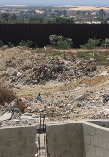
A distraught Rafah resident sits in the rubble of his former home, destroyed by the IDF in May. Behind him stands the metal wall, eight meters high and 1.6 kilometers long, that the IDF built eighty to ninety meters north of the border. Intended to enhance the security of Israeli forces on the border, the tempo of house demolitions increased dramatically after its completion in early 2003.
(c) 2004 Marc Garlasco/Human Rights Watch
Although the metal wall was built to enhance the security of Israeli forces on the border, the tempo of demolitions increased dramatically after it was completed in early 2003 (see Graph 1). From the beginning of the uprising in September 2000 until the end of November 2002, the IDF demolished a monthly average of 13.9 houses in Rafah. During 2003, this figure tripled to 47.8 homes per month. The increase continued in 2004, with a monthly average of 78 homes demolished during the first seven months of the year.148 In theory, the destruction of homes would bring some improvement to the security of Israeli forces on the border, although at the cost of destroying hundreds of homes and rendering thousands of civilians homeless. However, because the IDF built the metal wall several dozen meters inside the demolished area, it has effectively created a new “starting point” for justifying further demolitions. As of late May, the last rows of remaining homes in Rafah were between 100 and 200 meters from the wall, or 200 to 300 meters from the border. This trend is difficult to reconcile with the stated need to demolish houses to ensure the safety of Israeli forces on the border.
GRAPH 1: House Demolitions in Rafah by Month, October 2000-June 2004149
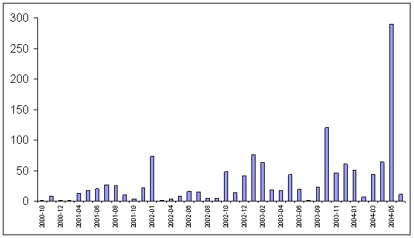
source: PCHR
The Block O neighborhood, a densely populated area consisting mostly of one-story refugee dwellings, has borne the brunt of the destruction. According to the Gaza-based Palestinian Centre for Human Rights (PCHR), which closely monitors and documents house demolitions, the Israeli military destroyed 426 homes in Block O between October 2000 and the end of June 2004.
[145] See, inter alia, “Israeli soldiers shoot at Christian Aid observers,” Christian Aid press release, June 25, 2004 and Inigo Gilmore, “Israeli soldiers open fire on visiting British MPs,” Daily Telegraph, June 20, 2004.
[146] Commercial satellite imagery of Israel/OPT is subject to special restrictions under U.S. law. While U.S. companies routinely provide satellite imagery of other countries at one-meter resolution or higher levels of quality, Israel/OPT imagery is released only at inferior two-meter resolution, in accordance with the Kyl-Bingaman amendment to the 1997 U.S. Defense Authorization Act.
[147] While major militaries affirm the right of an occupying power to temporarily control property for security purposes, confiscation (permanent seizure and transfer of ownership) is prohibited by Article 46 of the Hague Regulations.
[148] UNRWA data, as of August 2, 2004.
[149] Statistics compiled by PCHR. UNRWA has monthly disaggregations for house demolitions only from December 2002 onwards, from which point the monthly patterns (and overall Intifada data) closely match, though UNRWA counts significantly more demolitions in October 2003. Pre-December 2002 aggregates are also largely consistent.
| <<previous | index | next>> | October 2004 |